
Geography
41 items found

Allemann, F.
Geologische Karte Fürstentum Liechtenstein.
[Vaduz], Regierung des Fürstentums Liechtenstein, 1953. Large (102.0 x 67.0 cm), folded map, consisting of 25 rectangular sheets in full colour, mounted on linen. Handwritten and stamped label on the front-facing part of the linen map verso.
Read more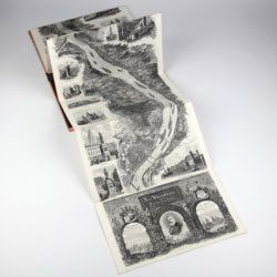
Arnold, F.
Halenza's neuestes Rhein-Panorama von Mainz bis Cöln. Einziges, durch die Berliner und Frankfurter Künstler gefässtes Urtheil, anerkanntes Kustwerk. Panorama du Rhin depuis Mayence jusq'à Cologne. Panorama of the Rhine, from Mentz to Cologne. [Complete with the rare text volume].
Mainz, J. Halenza, [1880]. Two parts in two. 8vo (text: 26.4 x 16.2 cm). Title page, 24 pp. (in English). Panorama: One folding lithographed view by F. Foltz (27 x 230 cm). Contained in original printed boards with the German title on one board, and the French/English titles on the other.
Read more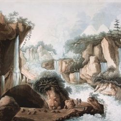
Belanger, L. and P. Vanlerberghe and S. Malgo
View of the torrent of the Lutschinen, and of the glaciers where it takes its source – Vue du torrent de la Lutschinen en Suisse, et des glaciers ou il prend sa source.
London, G. & W. Nicoll, 1800. Broadsheet (71.0 x 56.0 cm). Aquatint, finished by hand.
Read more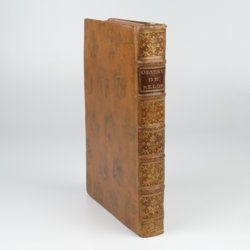
Belon, P.
Les observations de plusieurs singularitez et choses memorables, trouvees en Grece, Asie, Iudée, Egypte, Arabie, & autres pays estranges, redigées en trois liures. Reueuz de nouveau & augmentez de figures. Le catalogue contenant le plus notables choses, est en la page fuyuante.
Paris, H. de Marnef & G. Cavellat, 1588. 4to (22.1 x 15.4 cm). [xiv], 468, [ii] pp.; numerous woodcuts, some page-sized. 18th-century full tree calf. Spine with five raised bands, compartments rich gilt with floral patterns. Red morocco label with gilt title. Marbled endpapers. All edges red.
Read more
Clairaut, J. B., a.o.
Miscellanea Berolinensia ad incrementum scientiarum ex scriptis Societati Regiae Scientiarum exhibitis. Edita, continuatio III, sive Tomus IV. Cum figuris et indice materiarum.
Berolini, Johann Andreas Rüdiger, 1734. Small 4to (20.5 x 16.0 cm). vi, 405 pp.; 11 mostly folded engraved plates. Contemporary full mottled calf. Spine with five raised, gilt-ornamented bands; compartments rich gilt, red morocco label with gilt title. Edges speckled red.
Read more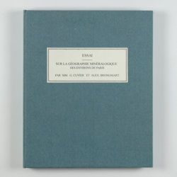
Cuvier, G. and A. [T.] Brongniart
Essai sur la géographie minéralogique des environs de Paris. Proof copy of the introductions, with corrections by Brogniart.
Paris, Institut Impériale de France, [1809 or 1810]. 4to (25.0 x 20.0 cm). 33 pp. Not bound. In a 20th century blue hardcover paper drop-box (26.8 x 22.0 cm) with printed label on the top board.
Read more
Dolomieu, D. [S. G. T.], De
Reise nach den liparischen Insuln oder Nachricht von den äolischen Insuln zur nähern Aufklärung der Geschichte der Vulkane. Nebst einer Abhandlung über eine Art von Luftvulkan, und einer andern über die Temperatur des Clima auf Maltha und die Verschiedenheit der wahren und fühlbaren Wärme.
Leipzig, Johann Gottfried Müller, 1783. 8vo (16.7 x 10.1 cm). 210, [ii] pp. Contemporary marbled boards, small leather label with gilt title on the spine. Edges yellow.
Read more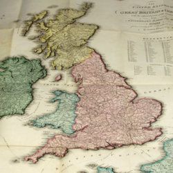
Enouy, J.
The United Kingdom of Great Britain & Ireland, with the adjacent parts of the Continent, from Amsterdam to Paris and Brest, compiled from a variety of the most authentic materials.
London, Samuel Leigh, 1818. Large, folded, coloured map (62.7 x 75.3 cm) of Great Britain and Ireland, and the continental coasts of the Channel and North Sea. In original reddish paper-covered boards, with printed label mounted.
Read more
Fuchs, W.
Die Venetianer Alpen. Ein Beitrag zur Kenntniss der Hochgebirgte, met einen geognostischen Karte und Gebirgteprofilen in achtzehn Tafeln.
Solothurn, Jent & Gassmann, 1844. Oblong folio (29.8 x 35.5 cm), [4], 60 pp.; 18 mostly hand-coloured engraved maps and plates. Text pages bordered with putti and goddesses. 19th century iridescent blue blind cloth.
Read more
[Geological map]
Geognostische Karte von Württemberg [AND] Begleitworte zur geognostischen Specialkarte von Württemberg.
Stuttgart, Das Königliches Statistisch-topographisches Bureau, Kohlhammer, Kleeblatt, 1863-1892. With 54 chromolithographed folded geological maps, all mounted on linen, numbered 1-48, 50-55, in two original, uniform burgundy boxes with gilt title on the lid. [AND] the "Begleitworte" 34 parts in one. Large 8vo (25.7 x 19.5 cm). Stuttgart, Königlich Statistischen Landesambt, (1865-1892). ca. 1,000 pp., and five hand-coloured wood-engraved or lithographed maps or geological profiles, and four wood-engraved plates. Contemporary half cloth over marbled boards. Spine with gilt title, ornaments, and the Württemberg coat-of-arms; patterned endpapers, and marbled edges.
Read more
Grandami, J.
Nova demonstratio immobilitatis terrae petita ex virtut magnetica. Demonstratio immobilitatis terrae. Terra in aeternum stat. Aequivaletia longitudinum. Meridianus universalis sine declinatione.
La Flèche, George Griveau, 1645. Small 4to (20.0 x 15.3 cm). Engraved title page, [vi], 162 pp. [1-24; 33-170]; six engraved plates (of which three larger, folded), 23 (groups of) large, engraved text illustrations (some occupying a whole page), one table in the text. Early to mid-19th century polished quarter calf over marbled boards. Spine with gilt lines and ornaments, and two red morocco labels with gilt title and date. Red edges.
Read more
Granö, J. G.
Beiträge zur Kenntnis der Eiszeit in der Nordwestlichen Mongolei und einigen ihrer südsibirischen Grenzgebirge. Geomorphologische Studien aus den Jahren 1905, 1906, 1907 und 1909.
Helsingfors, J. Simelii [for the Geographical Society of Finland], 1910. Large 8vo (24.9 x 16.5 cm). iv, 230 pp.; seven large, folded coloured maps, 19 photographic plates. Later quarter calf over pictorial boards.
Read more
