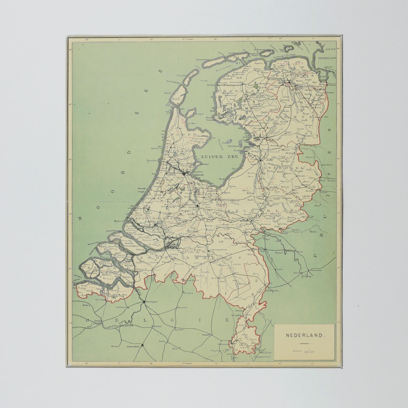
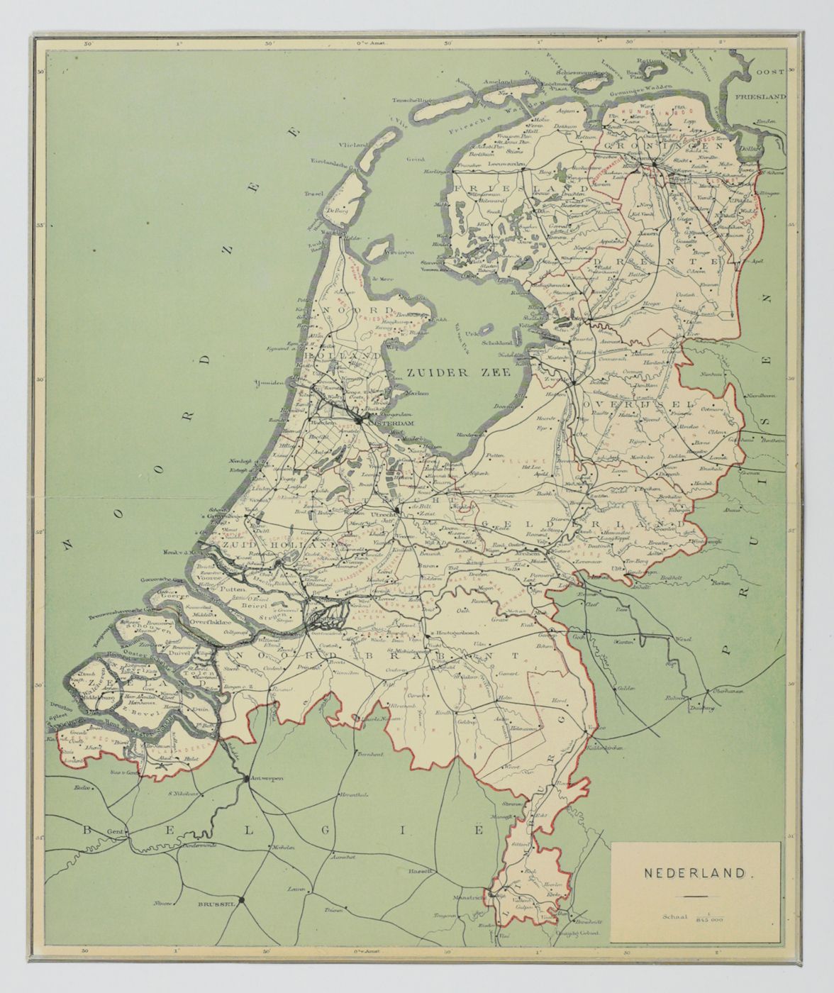
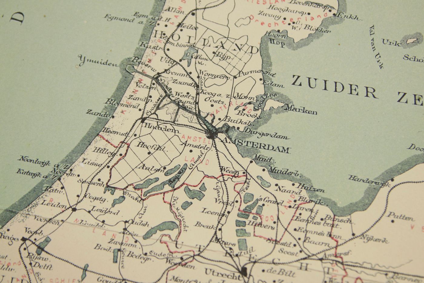
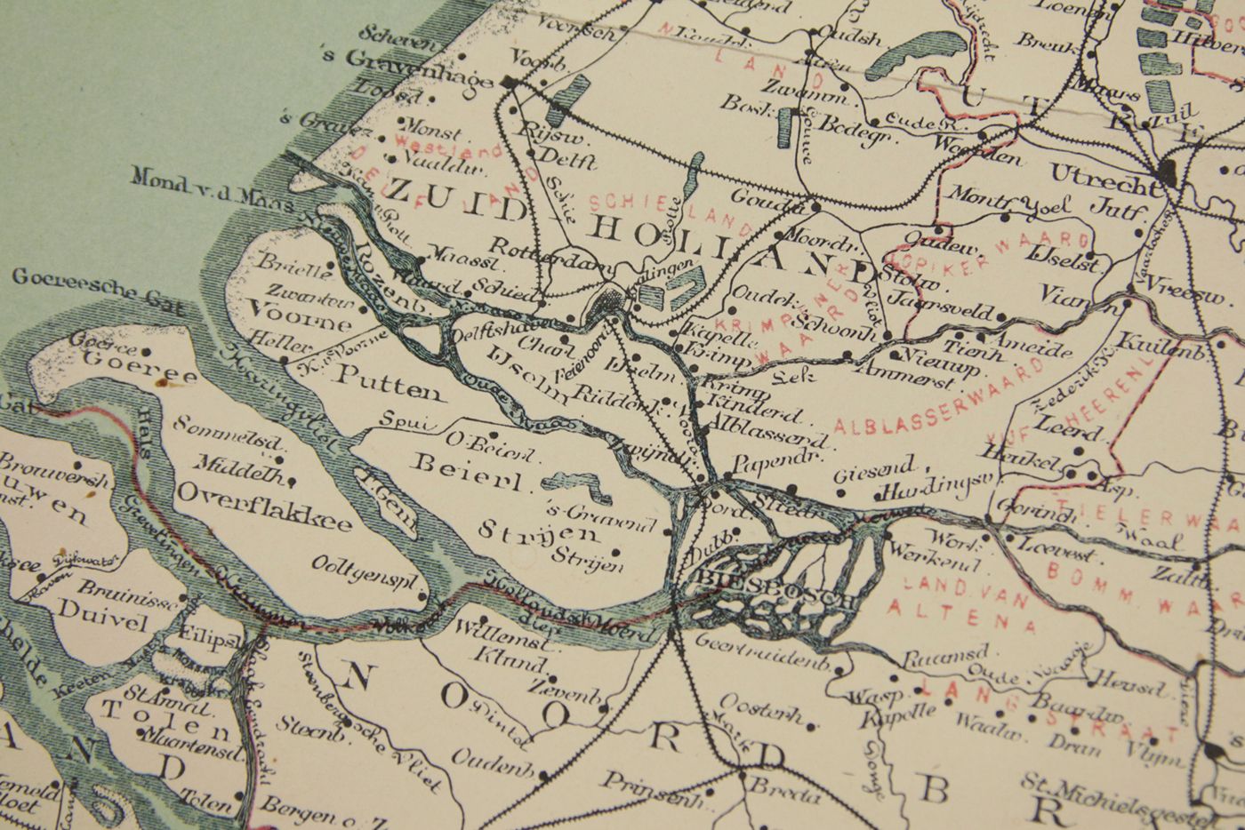
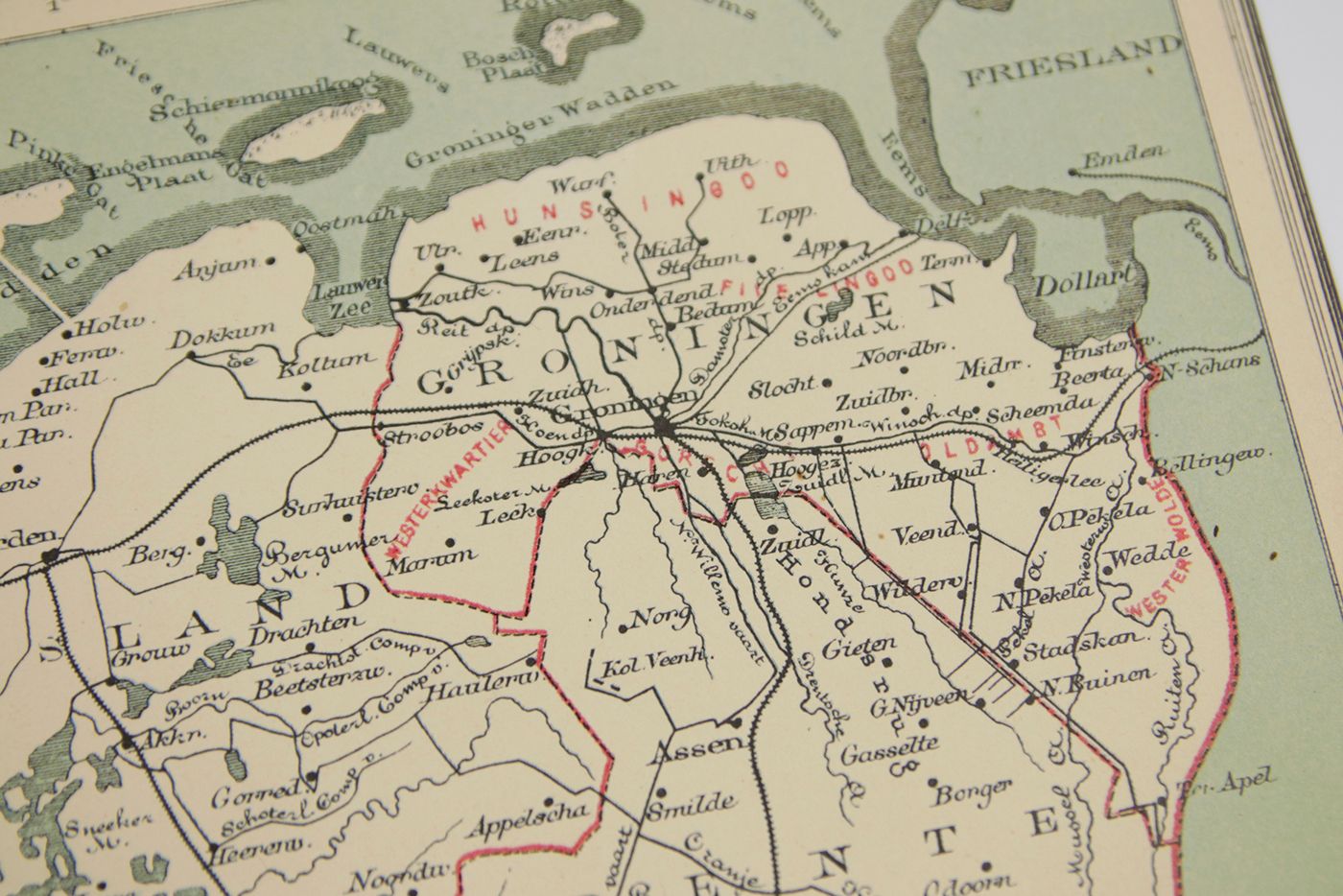
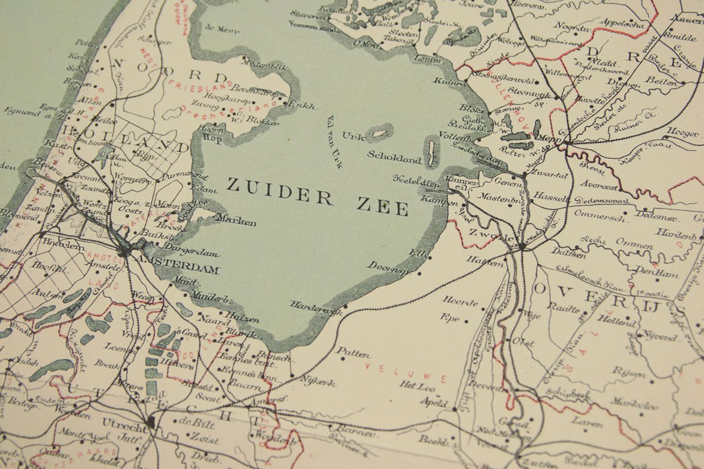
[Map]
Nederland. Schaal 1/845000. Map of the Netherlands.
No place or publisher indicated, [ca. 1872-1882]. Broadsheet (40.3 x 33.3 cm). Printed in black, blue and red.
The map shows the Netherlands on a scale of 1:845,000, with towns, waterways, and rail network, also in adjacent parts of Belgium and Germany. Despite this unusual scale we have not found any record of this map on the internet. It uses the meridian of Amsterdam, which was in use before 1884, when it was replaced by Greenwich. It also shows the dam built in the Wadden Sea between the island Ameland and the mainland, which was built in 1871-1872, but quickly fell into disrepair. Maintenance was stopped after the winter of 1881-1882. Horizontal fold (probably as issued), otherwise excellent, clean, unmarked.

Recently Viewed

![image for Études d'animaux. Tome premier - Tome second. [Complete].](https://schierenberg.nl/media/cache/product_thumb/77216/77216_x.jpg)
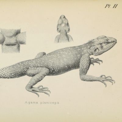
![image for Illustrations of the zoology of South Africa; consisting chiefly of figures and descriptions of the objects of natural history collected during an expedition into the interior of South Africa, in the years 1834, 1835, and 1836; fitted out by "The Cape of Good Hope Association for Exploring Central Africa". Published under the authority of the Lords Commissioners of Her Majesty's Treasury. Mammalia. Aves. Reptilia. Pisces. Invertebratae. [Complete].](https://schierenberg.nl/media/cache/product_thumb/74777/74777_x.jpg)
![image for Aztec Fable [Original book illustration, signed by the artist].](https://schierenberg.nl/media/cache/product_thumb/78307/78307_x.jpg)
![image for Fauna Republicii Populare Romîne. Insecta volumul IX Fascicula 4. Familia Ichneumonidae. Subfamiliile Ichneumoninae. Tribui Ichneumoninae Stenopneusticae. [AND] Fascicula 5. Familia Ichneumonidae. Subfamiliile Phaeogeninae si Alomyinae.](https://schierenberg.nl/media/cache/product_thumb/74521/74521.jpg)

![image for Vellum bifolium [16th century] binding. Book block of blank bluish leaves.](https://schierenberg.nl/media/cache/product_thumb/78210/78210.jpg)
![image for Mémoire sur les Granits de France, Comparés a Ceux d'Égypte. [AND] Mémoire sur Quelques Corps Fossiles Peu Connus. In: Histoire de l'Academie Royale des sciences, Année MDCCLI [1751], avec les mémoires de mathématique & de physique, pour la même année. Tirés des registres de cette académie.](https://schierenberg.nl/media/cache/product_thumb/60937/60937_x.jpg)
![image for Application de la main-d'oeuvre féminine au travail des obus. [AND] Usines André Citroën. Vues photographiques des usines André Citroën de mars a ocobre 1915 [at] 143 quai de javel, Paris.](https://schierenberg.nl/media/cache/product_thumb/77190/77190_x.jpg)
![image for Scientific results of the Elder Exploring Expedition. II. [AND] III (last).](https://schierenberg.nl/media/cache/product_thumb/77756/77756_x.jpg)
![image for De simplicibus medicamentis ex occidentali India delatis, quorum in medicina usus est. Nicolao Monardis Hispalensi Medico. Interprete Carolo Clusio atrebate. [AND] Simplicium medicamentorum ex nova orbe delatorum, quorum in medicina usus est, historiae liber tertius. Nicolao Monardes Hispalensi Medico: nunc verò primum Latio donatus, & notis illustrarus à Carolo Clusio a.](https://schierenberg.nl/media/cache/product_thumb/71356/71356_x.jpg)
![image for [Portrait by Jules Boilly].](https://schierenberg.nl/media/cache/product_thumb/77466/77466_x.jpg)
![image for Dr. Gregory's elements of catoptrics and dioptrics. To which is added I. A method for finding the foci of all specula as well as lens's universally. As also for magnifying or lessening a given object by a given speculum or lens in any assign'd proportion, &c. II. A solution to those problems which are left undemonstrated. III. A particular account of microscopes and telescopes, from Mr. Huygens. With an introduction shewing the discoveries made by catoptrics and dioptrics. [First English Edition].](https://schierenberg.nl/media/cache/product_thumb/70916/70916_x.jpg)
![image for Radiations. [Results of early experiment with radiated soil and vegetables]](https://schierenberg.nl/media/cache/product_thumb/74374/74374_x.jpg)
![image for Venezia Tridentina. [Woodcut print].](https://schierenberg.nl/media/cache/product_thumb/78425/78425_x.jpg)
![image for [Antique book case (Italian)]](https://schierenberg.nl/media/cache/product_thumb/69874/69874.jpg)
![image for De Bufone permagno [AND] Serpente magno Indiae Orientalis, Urobubalum deglutiente.](https://schierenberg.nl/media/cache/product_thumb/78137/78137_x.jpg)

![image for Histoire naturelle générale et particulière des mollusques terrestres et fluviatile. [Original full colour plates].](https://schierenberg.nl/media/cache/product_thumb/78398/78398_x.jpg)
![image for Iconographie et description de chenilles et lépidoptères inédits. I - III. [Complete].](https://schierenberg.nl/media/cache/product_thumb/77969/77969_x.jpg)
![image for De Dood van de Maagd Maria. The Death of the Virgin Mary. [Third and last state, with a remarkable wide margin].](https://schierenberg.nl/media/cache/product_thumb/77108/77108_x.jpg)
![image for Natural history of Victoria. Prodromus of the zoology of Victoria; figures and descriptions of the living species of all classes of the Victorian indigenous animals. Decade II. [Herpetology].](https://schierenberg.nl/media/cache/product_thumb/63388/63388_x.jpg)
![image for [Portrait of Christofel Colonus]](https://schierenberg.nl/media/cache/product_thumb/77918/77918_x.jpg)
![image for Spotted Cat. [Original of a book front-cover illustration, signed by the artist].](https://schierenberg.nl/media/cache/product_thumb/78305/78305_x.jpg)

