
Mountains
44 items found
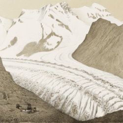
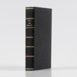
Agassiz, L.
Untersuchungen über die Gletscher. [Complete text and atlas].
Solothurn, Jent & Gassmann, 1840-1841; Neuchatel, H. Nicolet, 1840. Text: 8vo (21.5 x 14.2 cm). xii, 326, [i] pp. 19th-century pebbled half cloth over marbled boards. Spine with gilt ornamental bands and title. Greenish endpapers. Subtly marbled edges. Atlas: Oblong folio (29.7 x 44.0 cm). 18 lithographed plates of which 14 with printed overlays (as intended). Contemporary green quarter calf over green boards. Spine with gilt bands. Original pictorial title mounted on front board.
Read more
Allemann, F.
Geologische Karte Fürstentum Liechtenstein.
[Vaduz], Regierung des Fürstentums Liechtenstein, 1953. Large (102.0 x 67.0 cm), folded map, consisting of 25 rectangular sheets in full colour, mounted on linen. Handwritten and stamped label on the front-facing part of the linen map verso.
Read more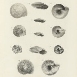
Annandale, [T.] N.
Zoological results of the Abor Expedition, 1911-12.
Calcutta, The Director of the Zoological Survey of India, 1912-1918. Large 8vo (26.0 x 18.0 cm). pp. 1-77, 191-410, 493-621 [of 629] pp., errata leaf; plates I-V, XVI-XXVII, XXXVIII-LIV [of 57] (mostly lithographs and photogravures), several text illustrations. Original, uniform printed wrappers.
Read more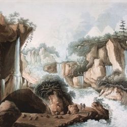
Belanger, L. and P. Vanlerberghe and S. Malgo
View of the torrent of the Lutschinen, and of the glaciers where it takes its source – Vue du torrent de la Lutschinen en Suisse, et des glaciers ou il prend sa source.
London, G. & W. Nicoll, 1800. Broadsheet (71.0 x 56.0 cm). Aquatint, finished by hand.
Read more
Bentham, G.
Catalogue des plantes indigènes des Pyrénées et du Bas Languedoc, avec des notes et observations sur les espèces nouvelles ou peu connues; précédé d'une Notice sur un voyage botanique fait dans les Pyrénées pendant l'été de 1825.
Paris, Madame Huzard, 1826. 8vo (20.7 x 12.5 cm [board size 21.3 x 13.3 cm]. 128 pp. Contemporary quarter calf over marbled boards. Spine rich gilt with ornamental bands and vignettes; and with red morocco label with gilt title. Marbled edges. original printed wrappers bound in.
Read more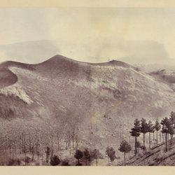
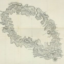
Berthier, P. [M.]
Photographic panorama of Mount Etna.
Paris, Paul Berthier, 1865. Very large board (93.0 x 45.0 cm), with original mounted albumen silver prints (panorama, in two parts of 25.0 x 36.2 cm and 25.0 x 35.0 cm, for a continuous image with a total width of 71.2 cm). Paul Berthier printed studio label pasted on verso.
Read more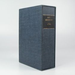
Bourrit, M. T.
Description des Alpes, Pennines et Rhetiennes; dédiée a.s.m. très-chrétienne Louis XVI, roi de France et de Navarre. Tome premier - second. [Complete].
Genève, J. P. Bonnant, 1781. In two volumes. 8vo (21.5 x 13.8 cm). xix, 247 pp.; [ii], 285 pp.; eight engraved plates, mainly of glaciers, and one folded engraved map of the Alps, several wood engraved vignettes in the text. Original uniform blind publishers' wrappers. Spines renewed with later printed labels. Contained in a later blue cloth slipcase (23.2 x 15.8 x 6.9 cm) with black morocco label with gilt title.
Read more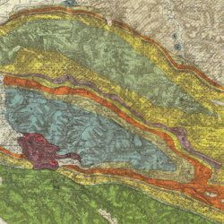
Carez, L. [L. H.]
La géologie des Pyrénées Françaises.
Paris, Imprimerie Nationale, 1903-1909. In six volumes, including the supplement. Large 4to (29.5 x 22.6 cm). 3,908 [ix, 3,899] pp.; 39 mainly geological folded maps or profiles (six in full-colour), and heliogravures (photogravures), some with printed overlays. Uniform contemporary half calf over marbled boards. Spines with four raised bands and gilt title.
Read more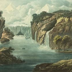
Conway, W. M.
Ascensions et explorations a sept mille mètres dans l'Himalaya.
Paris, Hachette, 1898. 8vo (17.9 x 11.4 cm). Title page with pictorial vignette, v, 242 pp.; frontispiece and 47 illustrations, mostly after photographs, and a map. Later black cloth with gilt title on the spine. Original pictorial front wrapper bound in.
Read more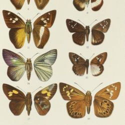

Forbes, J. D.
Reisen in den Savoyer Alpen und in anderen Theilen der Penninen-Kette, nebst Beobachtungen über die Gletscher.
Stuttgart, Schweizerbart, 1845. 8vo (21.0 x 13.3 cm). xii, 386 pp.; seven lithographed plates (of which one hand-coloured) and two folded lithographed maps depicting the Chamonix Alps. Early 20th-century cloth with mounted title and backstrip from original printed boards and spine.
Read more
Fuchs, W.
Die Venetianer Alpen. Ein Beitrag zur Kenntniss der Hochgebirgte, met einen geognostischen Karte und Gebirgteprofilen in achtzehn Tafeln.
Solothurn, Jent & Gassmann, 1844. Oblong folio (29.8 x 35.5 cm), [4], 60 pp.; 18 mostly hand-coloured engraved maps and plates. Text pages bordered with putti and goddesses. 19th century iridescent blue blind cloth.
Read more
Hedin, S. and F. Bergman
History of the Expedition in Asia 1927-1935. Part II. Reports from the Scientific Expedition to the North Western Provinces of China Under the Leadership of Dr Sven Hedin. The Sino-Swedish Expedition, Publication 24.
Stockholm, Elander, 1943. 4to (28.3 x 22.7 cm). xv, 215 pp.; 60 photographic plates. Contemporary full beige cloth with gilt leather labels on spine. Original buff, printed wrappers bound in.
Read more
Humboldt F. [H.] A. von [Freiherr]
Kosmos. Entwurf einer physischen Weltbeschreibung. [Complete set of five text volumes and the authorized atlas by Bromme].
Stuttgart and Tübingen, J. C. Cotta, 1845-1862. Six volumes (text and atlas) in seven. 8vo (21.0 x 13.1 cm). 3546 pp. (1 [1845]: xvi, 394; 2 [1847]: 544; 3 [1850] 645; 4 [1858] 650; 5.1-5.2 [1862] 1-592; 593-1297). Atlas in two parts (descriptive text; maps) oblong 4to (28.1 x 34.1 cm); two title pages, [ii], 136 pp. (for a total of 3674 pp.); 42 lithographed and engraved maps of which 39 originally hand-coloured. Text volumes: Uniform brown, grained half morocco over pebbled boards. Spines with gilt ornamental bands and vignettes. Yellow endpapers. Mottled edges. Atlas volumes: uniform brown full cloth. Spines with gilt ornamental bands and title. Original printed wrapper bound in.
Read more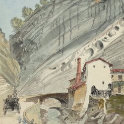
["JAM" (R. de Bouillé, Comte)]
[Original watercolour sketches of French landscapes]
[France], no place, no publisher, ca. 1863-1890. 13 oblong sheets (22.3 x 29.2 cm), all with fine watercolour paintings, either full-sized, or smaller, in a drawn rectangular frame. And one drawing on slightly smaller paper, more sketchy, in pencil.
Read more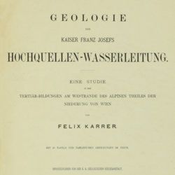
Karrer, F.
Geologie der Kaiser Franz Josefs Hochquellen-Wasserleitung. Eine Studie in den Tertiär-Bildungen am Westrande des alpinen Theiles der Niederung von Wien.
Wien, Hölder, 1877. Large 4to (33.5 x 25.5 cm). xiii, 420 pp.; 96 text engravings, 20 folded profiles, maps and lithographed plates, mostly coloured and several very large (size up to 32 x 100 cm), seven folded charts and tables. Later half cloth with paper label on the spine.
Read more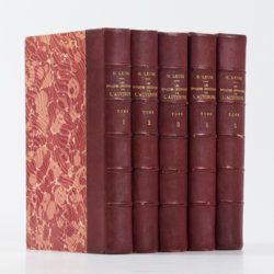
Lecoq, H.
Les époques géologiques de l'Auvergne. Avec 170 planches ou figures, dont plusieurs coloriées et des autographes de Dolomieu, d'Hauy & de De Saussure et un dessin fac simile de Madame Necker de Saussure. I-V. [Complete].
Paris, Baillière et fils, 1867. Five volumes in five. Large 8vo (23.7 x 15.2 cm). 2,758 pp.; 180 engraved and lithographed (tinted, or chromolithographed) plates [1-141, 143-169, 41(bis), 57(bis), 89bis, 107(bis), 149bis, 152bis, 163bis, 163ter, 165bis, 165ter, 165quater, 165quinter], on 107 sheets (several double-sized). Uniform burgundy half morocco over marbled boards. Spines with five raised bands, gilt title. Marbled endpapers. Speckled edges.
Read more
Lecoq, H.
[Auvergne] Itinéraire de Clermont au Puy de Dome, ou description de cette montagne et de la Vallée de Royat et Fontanat; seconde edition. [AND] Two other papers on the geology of Auvergne, by A. C. P. F. Von Lasaulx, and by J. B. Bouillet, bound in.
Paris, J. B. Baillière, 1836. 8vo (21.2 x 13.3 cm). vi, 102 pp. Early 20th century half morocco over marbled boards. Spine with five raised bands and gilt title. Marbled endpapers.
Read more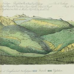
Lecoq, H. and J. B. Bouillet
Coup d'oeil sur la structure géologique et minéralogique du groupe des Monts Dores, accompagné de la description et des échantillons des substances minérales qui le composent.
Paris, Levrault and Clermont-Ferrand, Bouillet, Thibaud-Landriot, 1830. 8vo (20.0 x 13.1 cm). 48 pp.; five handcoloured lithographed plates (two much larger, folded) of geological views and profiles of the volcanological region of Puy-de-Dôme. Later red quarter calf over marbled boards. Gilt title on the spine. Marbled endpapers. Speckled edges.
Read more
