
Mountains
45 items found

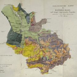
Merian, P.
Uebersicht der Beschaffenheit der Gebirgsbildungen in den Umgebungen von Basel, mit besondrer Hinsicht auf das Juragebirge im Allgemeinen.
Basel, Schweighauser, 1821. 8vo (20.2 x 12.1 cm). xii, 156 pp; one large, folded hand-coloured map and one hand-coloured plate. Original printed wrappers.
Read more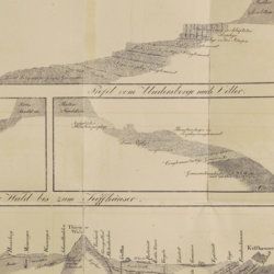
Oeynhausen, C. von and H. von Dechen and H. von La Roche
Geognostische Umrisse der Rheinländer zwischen Basel und Mainz mit besonderer Rücksicht auf das Vorkommen des Steinsalzes, nach Beobachtungen entworfen auf einer Reise im Jahre 1823 gesammelt.
Essen, G. Bädeker, 1825. Two volumes in one. 8vo (19.8 x 12.0 cm). 782 pp.; one folding lithographed plate with several geological profiles. Contemporary half cloth over marbled boards. Paper label with the title in an old hand on the spine. Original endpapers.
Read more
Bentham, G.
Catalogue des plantes indigènes des Pyrénées et du Bas Languedoc, avec des notes et observations sur les espèces nouvelles ou peu connues; précédé d'une Notice sur un voyage botanique fait dans les Pyrénées pendant l'été de 1825.
Paris, Madame Huzard, 1826. 8vo (20.7 x 12.5 cm [board size 21.3 x 13.3 cm]. 128 pp. Contemporary quarter calf over marbled boards. Spine rich gilt with ornamental bands and vignettes; and with red morocco label with gilt title. Marbled edges. original printed wrappers bound in.
Read more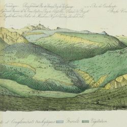
Lecoq, H. and J. B. Bouillet
Coup d'oeil sur la structure géologique et minéralogique du groupe des Monts Dores, accompagné de la description et des échantillons des substances minérales qui le composent.
Paris, Levrault and Clermont-Ferrand, Bouillet, Thibaud-Landriot, 1830. 8vo (20.0 x 13.1 cm). 48 pp.; five handcoloured lithographed plates (two much larger, folded) of geological views and profiles of the volcanological region of Puy-de-Dôme. Later red quarter calf over marbled boards. Gilt title on the spine. Marbled endpapers. Speckled edges.
Read more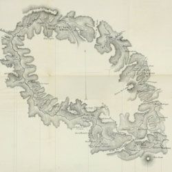

Unger, F.
Ueber den Einfluss des Bodens auf die Vertheilung der Gewächse nachgewissen in der Vegetation des nordöstlichen Tirols.
Wien, Rohrmann und Schweigerd, 1836. 8vo (21.4 x 13.5 cm). xxiv, 367 pp.; one hand-coloured engraved plate of Kitzbühl, one large, folded, hand-coloured geological-geographical map, one large, folded hand-coloured sheet with geological profile, five folded charts with meteorological observations (four) and botanical observations (one), many tables in the text. Contemporary quarter calf over marbled boards. Spine with gilt lines, vignettes, and title. Marbled endpapers; speckled edges.
Read more
Lecoq, H.
[Auvergne] Itinéraire de Clermont au Puy de Dome, ou description de cette montagne et de la Vallée de Royat et Fontanat; seconde edition. [AND] Two other papers on the geology of Auvergne, by A. C. P. F. Von Lasaulx, and by J. B. Bouillet, bound in.
Paris, J. B. Baillière, 1836. 8vo (21.2 x 13.3 cm). vi, 102 pp. Early 20th century half morocco over marbled boards. Spine with five raised bands and gilt title. Marbled endpapers.
Read more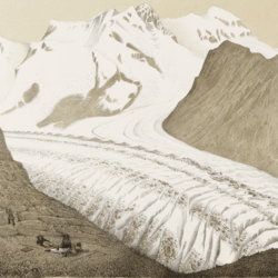
Agassiz, L.
Untersuchungen über die Gletscher. [Complete text and atlas].
Solothurn, Jent & Gassmann, 1840-1841; Neuchatel, H. Nicolet, 1840. Text: 8vo (21.5 x 14.2 cm). xii, 326, [i] pp. 19th-century pebbled half cloth over marbled boards. Spine with gilt ornamental bands and title. Greenish endpapers. Subtly marbled edges. Atlas: Oblong folio (29.7 x 44.0 cm). 18 lithographed plates of which 14 with printed overlays (as intended). Contemporary green quarter calf over green boards. Spine with gilt bands. Original pictorial title mounted on front board.
Read more
Fuchs, W.
Die Venetianer Alpen. Ein Beitrag zur Kenntniss der Hochgebirgte, met einen geognostischen Karte und Gebirgteprofilen in achtzehn Tafeln.
Solothurn, Jent & Gassmann, 1844. Oblong folio (29.8 x 35.5 cm), [4], 60 pp.; 18 mostly hand-coloured engraved maps and plates. Text pages bordered with putti and goddesses. 19th century iridescent blue blind cloth.
Read more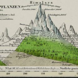
Humboldt F. [H.] A. von [Freiherr]
Kosmos. Entwurf einer physischen Weltbeschreibung. [Complete set of five text volumes and the authorized atlas by Bromme].
Stuttgart and Tübingen, J. C. Cotta, 1845-1862. Six volumes (text and atlas) in seven. 8vo (21.0 x 13.1 cm). 3546 pp. (1 [1845]: xvi, 394; 2 [1847]: 544; 3 [1850] 645; 4 [1858] 650; 5.1-5.2 [1862] 1-592; 593-1297). Atlas in two parts (descriptive text; maps) oblong 4to (28.1 x 34.1 cm); two title pages, [ii], 136 pp. (for a total of 3674 pp.); 42 lithographed and engraved maps of which 39 originally hand-coloured. Text volumes: Uniform brown, grained half morocco over pebbled boards. Spines with gilt ornamental bands and vignettes. Yellow endpapers. Mottled edges. Atlas volumes: uniform brown full cloth. Spines with gilt ornamental bands and title. Original printed wrapper bound in.
Read more
Forbes, J. D.
Reisen in den Savoyer Alpen und in anderen Theilen der Penninen-Kette, nebst Beobachtungen über die Gletscher.
Stuttgart, Schweizerbart, 1845. 8vo (21.0 x 13.3 cm). xii, 386 pp.; seven lithographed plates (of which one hand-coloured) and two folded lithographed maps depicting the Chamonix Alps. Early 20th-century cloth with mounted title and backstrip from original printed boards and spine.
Read more
