
Geography
41 items found
[Various authors]
Annales des Mines. Series III-VI. Atlases.
Paris, Ecole de Mines, 1832-1866. Two series in four. Oblong folio (40.5 x 22.0 cm) with 758 (of 759? see below) engraved and lithographed plates and maps, of which 29 are hand-coloured geological maps or profiles. Contemporary uniform red cloth. Gilt titles on the spines and front boards. Marbled endpapers.
Read more
Phillip, A.
Arthur Phillips Reise nach der Botany-Bay, nebst Auszügen aus den Tagebüchern der neuesten Brittischen Entdecker in der Südsee.
Hamburg, Benjamin Gottlob Hoffmann, 1791. 8vo (20.4 x 11.1 cm). [xiv], viii, [9]-264 pp.; one engraved portrait as a frontispiece, one engraved title vignette, eight engraved plates and one hand-coloured folded map. Contemporary mottled half calf over marbled boards. reen moroccolabel with gilt title on the spine. Blue endpapers.
Read more
Zannoni, R.
Atlas historique de la France ancienne et moderne contenant tous les lieux illustrés par les événements les plus mémorables de notre histoire; ... depuis Pharamond jusqu'a Louis XV....
Paris, S. Desnos, 1782. Large 4to (28.8 x 22.2 cm). Beautifully engraved double-sized title page; similar folding dedication page (by Desnos and Zannoni), 16 pp.; 59 hand-coloured engraved maps (56 double-sized with ornamental borders; two much larger, of which one dated 1774, and the other 1776). Contemporary half calf over marbled boards. Spine with five raised bands; compartments with gilt floral patterns and red morocco label with gilt title. Edges red.
Read more
Lecoq, H.
[Auvergne] Itinéraire de Clermont au Puy de Dome, ou description de cette montagne et de la Vallée de Royat et Fontanat; seconde edition. [AND] Two other papers on the geology of Auvergne, by A. C. P. F. Von Lasaulx, and by J. B. Bouillet, bound in.
Paris, J. B. Baillière, 1836. 8vo (21.2 x 13.3 cm). vi, 102 pp. Early 20th century half morocco over marbled boards. Spine with five raised bands and gilt title. Marbled endpapers.
Read more
Radermacher, J. C. M. (ed.)
Bataviaasch Genootschap der Kunsten en Wetenschappen: Verhandelingen. Volume 1.
Batavia, Ter Lands Drukkerij, 1820. 8vo (18.6 x 12.5 cm) 266 pp., 59 pp. Voorbericht [foreword], 23 pp. Nabericht [afterword] and Bladwijzer [index]. Contemporary half calf with mottled paper over boards.
Read more
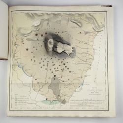
Granö, J. G.
Beiträge zur Kenntnis der Eiszeit in der Nordwestlichen Mongolei und einigen ihrer südsibirischen Grenzgebirge. Geomorphologische Studien aus den Jahren 1905, 1906, 1907 und 1909.
Helsingfors, J. Simelii [for the Geographical Society of Finland], 1910. Large 8vo (24.9 x 16.5 cm). iv, 230 pp.; seven large, folded coloured maps, 19 photographic plates. Later quarter calf over pictorial boards.
Read more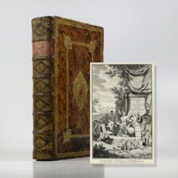
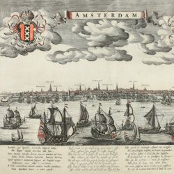
Kaempfer, E.
De beschryving van Japan, behelsende een verhaal van den ouden en tegenwoordigen staat en regeering van dat Ryk.
The Hague, P. Gosse and J. Neaulme; Amsterdam, Balthasar Lakeman, 1729. Folio (37.5 x 25.0 cm). 500 pp. Half-title, title page explanation, frontispiece (engraved title) by I. C. Philips, letterpress title in red and black; 48 double-sized maps and plates (I-XVII, XXX-XLV, XXIV*, A-BXXVIII, A-BXXIX). Contemporary full mottled calf; spine with six raised bands; compartments rich gilt with fine, elaborate floral ornaments, and red morocco label with gilt title; boards with double gilt roll stamped border, gilt floral corner pieces and central vignettes. Mottled edges.
Read more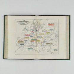

Fuchs, W.
Die Venetianer Alpen. Ein Beitrag zur Kenntniss der Hochgebirgte, met einen geognostischen Karte und Gebirgteprofilen in achtzehn Tafeln.
Solothurn, Jent & Gassmann, 1844. Oblong folio (29.8 x 35.5 cm), [4], 60 pp.; 18 mostly hand-coloured engraved maps and plates. Text pages bordered with putti and goddesses. 19th century iridescent blue blind cloth.
Read more
Rothpletz, A.
Ein geologischer Querschnitt durch die Ost-Alpen nebst Anhang über die sog. Glarner Doppelfalte.
Stuttgart, E. Schweizerbart (E. Koch), 1894. 8vo (22.4 x 15.4 cm). iv, 208 pp.; two full colour folded profiles of which one measuring 22.5 x 352.0 cm (!), 115 text illustrations. Contemporary half cloth over marbled boards. Gilt lines and two red morocco labels with gilt title on the spine. Edges speckled.
Read more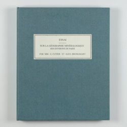
Cuvier, G. and A. [T.] Brongniart
Essai sur la géographie minéralogique des environs de Paris. Proof copy of the introductions, with corrections by Brogniart.
Paris, Institut Impériale de France, [1809 or 1810]. 4to (25.0 x 20.0 cm). 33 pp. Not bound. In a 20th century blue hardcover paper drop-box (26.8 x 22.0 cm) with printed label on the top board.
Read more
