
Geography
41 items found
[Various authors]
Annales des Mines. Series III-VI. Atlases.
Paris, Ecole de Mines, 1832-1866. Two series in four. Oblong folio (40.5 x 22.0 cm) with 758 (of 759? see below) engraved and lithographed plates and maps, of which 29 are hand-coloured geological maps or profiles. Contemporary uniform red cloth. Gilt titles on the spines and front boards. Marbled endpapers.
Read more
Phillip, A.
Arthur Phillips Reise nach der Botany-Bay, nebst Auszügen aus den Tagebüchern der neuesten Brittischen Entdecker in der Südsee.
Hamburg, Benjamin Gottlob Hoffmann, 1791. 8vo (20.4 x 11.1 cm). [xiv], viii, [9]-264 pp.; one engraved portrait as a frontispiece, one engraved title vignette, eight engraved plates and one hand-coloured folded map. Contemporary mottled half calf over marbled boards. reen moroccolabel with gilt title on the spine. Blue endpapers.
Read more
Zannoni, R.
Atlas historique de la France ancienne et moderne contenant tous les lieux illustrés par les événements les plus mémorables de notre histoire; ... depuis Pharamond jusqu'a Louis XV....
Paris, S. Desnos, 1782. Large 4to (28.8 x 22.2 cm). Beautifully engraved double-sized title page; similar folding dedication page (by Desnos and Zannoni), 16 pp.; 59 hand-coloured engraved maps (56 double-sized with ornamental borders; two much larger, of which one dated 1774, and the other 1776). Contemporary half calf over marbled boards. Spine with five raised bands; compartments with gilt floral patterns and red morocco label with gilt title. Edges red.
Read more
Lecoq, H.
[Auvergne] Itinéraire de Clermont au Puy de Dome, ou description de cette montagne et de la Vallée de Royat et Fontanat; seconde edition. [AND] Two other papers on the geology of Auvergne, by A. C. P. F. Von Lasaulx, and by J. B. Bouillet, bound in.
Paris, J. B. Baillière, 1836. 8vo (21.2 x 13.3 cm). vi, 102 pp. Early 20th century half morocco over marbled boards. Spine with five raised bands and gilt title. Marbled endpapers.
Read more
Radermacher, J. C. M. (ed.)
Bataviaasch Genootschap der Kunsten en Wetenschappen: Verhandelingen. Volume 1.
Batavia, Ter Lands Drukkerij, 1820. 8vo (18.6 x 12.5 cm) 266 pp., 59 pp. Voorbericht [foreword], 23 pp. Nabericht [afterword] and Bladwijzer [index]. Contemporary half calf with mottled paper over boards.
Read more
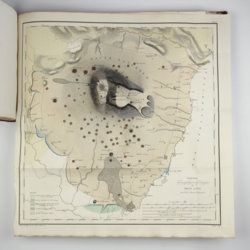
Granö, J. G.
Beiträge zur Kenntnis der Eiszeit in der Nordwestlichen Mongolei und einigen ihrer südsibirischen Grenzgebirge. Geomorphologische Studien aus den Jahren 1905, 1906, 1907 und 1909.
Helsingfors, J. Simelii [for the Geographical Society of Finland], 1910. Large 8vo (24.9 x 16.5 cm). iv, 230 pp.; seven large, folded coloured maps, 19 photographic plates. Later quarter calf over pictorial boards.
Read more
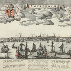
Kaempfer, E.
De beschryving van Japan, behelsende een verhaal van den ouden en tegenwoordigen staat en regeering van dat Ryk.
The Hague, P. Gosse and J. Neaulme; Amsterdam, Balthasar Lakeman, 1729. Folio (37.5 x 25.0 cm). 500 pp. Half-title, title page explanation, frontispiece (engraved title) by I. C. Philips, letterpress title in red and black; 48 double-sized maps and plates (I-XVII, XXX-XLV, XXIV*, A-BXXVIII, A-BXXIX). Contemporary full mottled calf; spine with six raised bands; compartments rich gilt with fine, elaborate floral ornaments, and red morocco label with gilt title; boards with double gilt roll stamped border, gilt floral corner pieces and central vignettes. Mottled edges.
Read more

Fuchs, W.
Die Venetianer Alpen. Ein Beitrag zur Kenntniss der Hochgebirgte, met einen geognostischen Karte und Gebirgteprofilen in achtzehn Tafeln.
Solothurn, Jent & Gassmann, 1844. Oblong folio (29.8 x 35.5 cm), [4], 60 pp.; 18 mostly hand-coloured engraved maps and plates. Text pages bordered with putti and goddesses. 19th century iridescent blue blind cloth.
Read more
Rothpletz, A.
Ein geologischer Querschnitt durch die Ost-Alpen nebst Anhang über die sog. Glarner Doppelfalte.
Stuttgart, E. Schweizerbart (E. Koch), 1894. 8vo (22.4 x 15.4 cm). iv, 208 pp.; two full colour folded profiles of which one measuring 22.5 x 352.0 cm (!), 115 text illustrations. Contemporary half cloth over marbled boards. Gilt lines and two red morocco labels with gilt title on the spine. Edges speckled.
Read more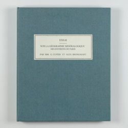
Cuvier, G. and A. [T.] Brongniart
Essai sur la géographie minéralogique des environs de Paris. Proof copy of the introductions, with corrections by Brogniart.
Paris, Institut Impériale de France, [1809 or 1810]. 4to (25.0 x 20.0 cm). 33 pp. Not bound. In a 20th century blue hardcover paper drop-box (26.8 x 22.0 cm) with printed label on the top board.
Read more
[Geological map]
Geognostische Karte von Württemberg [AND] Begleitworte zur geognostischen Specialkarte von Württemberg.
Stuttgart, Das Königliches Statistisch-topographisches Bureau, Kohlhammer, Kleeblatt, 1863-1892. With 54 chromolithographed folded geological maps, all mounted on linen, numbered 1-48, 50-55, in two original, uniform burgundy boxes with gilt title on the lid. [AND] the "Begleitworte" 34 parts in one. Large 8vo (25.7 x 19.5 cm). Stuttgart, Königlich Statistischen Landesambt, (1865-1892). ca. 1,000 pp., and five hand-coloured wood-engraved or lithographed maps or geological profiles, and four wood-engraved plates. Contemporary half cloth over marbled boards. Spine with gilt title, ornaments, and the Württemberg coat-of-arms; patterned endpapers, and marbled edges.
Read more
Allemann, F.
Geologische Karte Fürstentum Liechtenstein.
[Vaduz], Regierung des Fürstentums Liechtenstein, 1953. Large (102.0 x 67.0 cm), folded map, consisting of 25 rectangular sheets in full colour, mounted on linen. Handwritten and stamped label on the front-facing part of the linen map verso.
Read more
Arnold, F.
Halenza's neuestes Rhein-Panorama von Mainz bis Cöln. Einziges, durch die Berliner und Frankfurter Künstler gefässtes Urtheil, anerkanntes Kustwerk. Panorama du Rhin depuis Mayence jusq'à Cologne. Panorama of the Rhine, from Mentz to Cologne. [Complete with the rare text volume].
Mainz, J. Halenza, [1880]. Two parts in two. 8vo (text: 26.4 x 16.2 cm). Title page, 24 pp. (in English). Panorama: One folding lithographed view by F. Foltz (27 x 230 cm). Contained in original printed boards with the German title on one board, and the French/English titles on the other.
Read more
Lesseps, [J. B. B.] de
Herrn von Lesseps Gefährten des Grafen de la Perouse Reise durch Kamtschatka und Sibirien nach Frankreich. Aus dem Französischen übersetzt. Mit Anmerkungen von Johann Reinhold Forster.
Berlin, Voss, 1791. 8vo (22.4 x 14.5 cm). xxviii, 302 [303-544] pp.; two engraved, folded maps, one folded table. Original blind boards.
Read more
Heeres, J. E.
Het aandeel der Nederlanders in de ontdekking van Australië 1606-1765. The part borne by the Dutch in the discovery of Australia 1606-1765.
Leiden, E. J. Brill [AND] London, Luzac and Co., 1899. Large 4to (35.0 x 25.2 cm) 240 [xvii, 100 double; 101-106 single] pp., two large, folding full colour maps, 17 maps in the text. Contemporary grey buckram with gilt title on the spine. Floral-patterned endpapers.
Read more
Torre, G. M. Della
Histoire et phénomènes du Vésuve. Exposés par le Pere Dom Jean-Marie Della-Torre, clerc régulier sommasque, garde bde la bibliothéque & du cabinet du roi des Deux-Siciles, & correspondant de l'Académie Royale des Sciences de Paris. Traduction de l'Italien par M. l'abbé Péton.
Paris, Jean-Thomas Hérissant, 1760. 12mo (16.3 x 9.2 cm). xxiv, 399 pp., one large folded map of Mount Vesuvius, the Bay of Naples and surroundings, and five folded plates with panoramas and other views of the volcano, caldera, etc. Contemporary full mottled calf. Spine with five raised bands. Compartments with gilt floral vignettes and small red morocco label with gilt title. Marbled endpapers, marbled edges.
Read more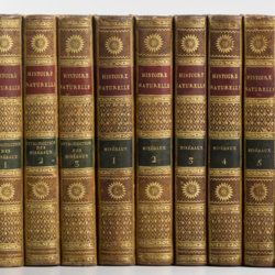
Sonnini, C. S.
Histoire naturelle générale et particulière, par Leclerc de Buffon; nouvelle edition accompagnée de notes, et dans laquelle les supplémens sont insérés dans le premier texte, à la place qui leur convient. Ouvrage formant un cours complet d'histoire naturelle; redige par C. S. Sonnini, membre de plusieurs sociétés savantes. Tomes Mineraux 1-16. [Théorie de la terre 1-3; Epoques de la nature; Introduction a l'histoire des minéraux 1-3; Mineraux 1-9].
Paris, Dufart, An VIII (1798) - X (1800). 16 parts in 16. 8vo (19.5 x 12.2 cm). Engraved frontispiece, 7156 pp.; nine engraved plates, four folded maps. Contemporary uniform full tree calf. Boards with gilt ornamented borders and gilt dentelles. Rich gilt spines, gilt titles on two (red and black) morocco labels, marbled flyleaves, all edges speckled red on yellow.
Read more
Le Goux de Flaix, A. [Legoux]
Historisch-geographisch politischer Versuch über Ostindien nebst der Schilderung von dessen Handel nach Le Goux de Flaix. Mit Noten, Anmerkungen und einer Vorrede von E. A. W. v. Z[immermann].
Leipzig, Heinrich Gräff, 1810. Two volumes in two. 8vo (17.5 x 10.7 cm). 892 [I: viii, 444; II: iv, 436] pp.; one folded engraving of the Jagannath temple. Contemporary uniform tree calf resembling paper boards with ruled borders, olive and brown gilt-lettered morocco labels on spines.
Read more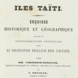
Vincendon-Dumoulin, [C. A.] and C. [L. F.] Desgraz
Iles Taïti. Esquisse historique et géographique précédée de considérations générales sur la colonisation française dans l'Océanie. Première Partie - Deuxième Partie. [Complete].
Paris, Arthus Bertrand, 1844. In two parts. 8vo (21.5 x 14.1 cm). Half-titles, title pages, 1056 pp. (pagination continuous); two large, engraved maps. Original uniform, printed wrappers.
Read more
Belon, P.
Les observations de plusieurs singularitez et choses memorables, trouvees en Grece, Asie, Iudée, Egypte, Arabie, & autres pays estranges, redigées en trois liures. Reueuz de nouveau & augmentez de figures. Le catalogue contenant le plus notables choses, est en la page fuyuante.
Paris, H. de Marnef & G. Cavellat, 1588. 4to (22.1 x 15.4 cm). [xiv], 468, [ii] pp.; numerous woodcuts, some page-sized. 18th-century full tree calf. Spine with five raised bands, compartments rich gilt with floral patterns. Red morocco label with gilt title. Marbled endpapers. All edges red.
Read more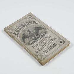
Harris, W. H.
Louisiana products, resources and attractions, with a sketch of the parishes. A hand book of reliable information concerning the State.
New Orleans, LA, W. M. Harris [for the State], 1881. 8vo (23.4 x 14.9 cm). 248 pp., one large, folded coloured map, one lithographed frontispiece portrait. Original pictorial wrappers. In protective transparent cover.
Read more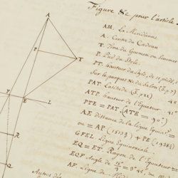
[Mairan, J. J. d'Ortous de]
Meridienne de Sain-Port ou Saint Assise. [Manuscript].
Unpublished, 1734-1761. Folio (36.0 x 23.2 cm). Half-title, contents leaf, title page, 31 pp. [numbered 1-31], 20 blank leaves. Contemporary full mottled calf. Spine with six raised bands; compartments rich gilt with lion vignettes and floral corner pieces, and burgundy morocco label with gilt title. Boards with double gilt-lined borders. Marbled endpapers.
Read more
