
Geography
42 items found
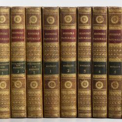
Sonnini, C. S.
Histoire naturelle générale et particulière, par Leclerc de Buffon; nouvelle edition accompagnée de notes, et dans laquelle les supplémens sont insérés dans le premier texte, à la place qui leur convient. Ouvrage formant un cours complet d'histoire naturelle; redige par C. S. Sonnini, membre de plusieurs sociétés savantes. Tomes Mineraux 1-16. [Théorie de la terre 1-3; Epoques de la nature; Introduction a l'histoire des minéraux 1-3; Mineraux 1-9].
Paris, Dufart, An VIII (1798) - X (1800). 16 parts in 16. 8vo (19.5 x 12.2 cm). Engraved frontispiece, 7156 pp.; nine engraved plates, four folded maps. Contemporary uniform full tree calf. Boards with gilt ornamented borders and gilt dentelles. Rich gilt spines, gilt titles on two (red and black) morocco labels, marbled flyleaves, all edges speckled red on yellow.
Read more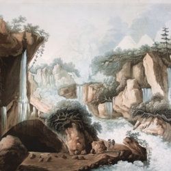
Belanger, L. and P. Vanlerberghe and S. Malgo
View of the torrent of the Lutschinen, and of the glaciers where it takes its source – Vue du torrent de la Lutschinen en Suisse, et des glaciers ou il prend sa source.
London, G. & W. Nicoll, 1800. Broadsheet (71.0 x 56.0 cm). Aquatint, finished by hand.
Read more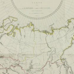
Storch, H.
Tableau historique et statistique de l'empire de Russie à fin du dix-huitième siècle. Edition française.
Basle, J. Decker, and Paris, C. Pougens, 1801. Two volumes in two. 8vo (19.6 x12.3 cm). 1,004 pp. [xxii, 407, 80; 423, 72]; two large, partly coloured folded maps (the largest with printed dimensions 67 x 36.5 cm), three folded tables. Uniform contemporary tree-calf. Spines rich gilt with gilt title on blue morocco label. Marbled endpapers. Edges yellow, speckled with red.
Read more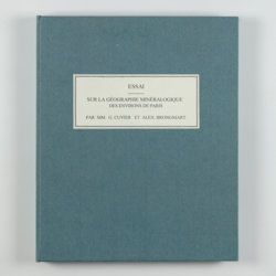
Cuvier, G. and A. [T.] Brongniart
Essai sur la géographie minéralogique des environs de Paris. Proof copy of the introductions, with corrections by Brogniart.
Paris, Institut Impériale de France, [1809 or 1810]. 4to (25.0 x 20.0 cm). 33 pp. Not bound. In a 20th century blue hardcover paper drop-box (26.8 x 22.0 cm) with printed label on the top board.
Read more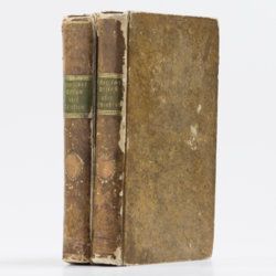
Le Goux de Flaix, A. [Legoux]
Historisch-geographisch politischer Versuch über Ostindien nebst der Schilderung von dessen Handel nach Le Goux de Flaix. Mit Noten, Anmerkungen und einer Vorrede von E. A. W. v. Z[immermann].
Leipzig, Heinrich Gräff, 1810. Two volumes in two. 8vo (17.5 x 10.7 cm). 892 [I: viii, 444; II: iv, 436] pp.; one folded engraving of the Jagannath temple. Contemporary uniform tree calf resembling paper boards with ruled borders, olive and brown gilt-lettered morocco labels on spines.
Read more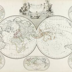
Malte-Brun, [C.]
Précis de la géographie universelle, ou description de toutes les partes du monde, sur un plan nouveau d'après les grandes divisions naturelles du globe. Précédée de l'histoire de la géographie chez les peuples anciens et modernes, et d'une théorie générale de la géographie mathématique, physique et politique. Collection de cartes géographiques. [AND] Atlas supplémentaire du Précis de la géographie universelle de M. Malte-Brun; dressé conformément au texte de cet ouvrage et sous les yeax de l'auteur, par M. Lapie, capitaine ingénieur géographie. [Atlases].
Paris, François Buisson, 1810-1812. Two parts in one. Folio (34.0 x 25.8 cm). Title pages, 14 pp. [ii; 12]; 75 [24; 51] engraved and hand-coloured maps. 19th-century black quarter calf over black pebbled boards. Spine with four slightly raised, gilt-lined bands; compartments with triple-gilt borders and title. Marbled endpapers. All edges gilt.
Read more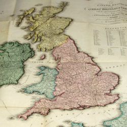
Enouy, J.
The United Kingdom of Great Britain & Ireland, with the adjacent parts of the Continent, from Amsterdam to Paris and Brest, compiled from a variety of the most authentic materials.
London, Samuel Leigh, 1818. Large, folded, coloured map (62.7 x 75.3 cm) of Great Britain and Ireland, and the continental coasts of the Channel and North Sea. In original reddish paper-covered boards, with printed label mounted.
Read more
Radermacher, J. C. M. (ed.)
Bataviaasch Genootschap der Kunsten en Wetenschappen: Verhandelingen. Volume 1.
Batavia, Ter Lands Drukkerij, 1820. 8vo (18.6 x 12.5 cm) 266 pp., 59 pp. Voorbericht [foreword], 23 pp. Nabericht [afterword] and Bladwijzer [index]. Contemporary half calf with mottled paper over boards.
Read more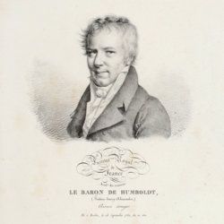
[Various authors]
Annales des Mines. Series III-VI. Atlases.
Paris, Ecole de Mines, 1832-1866. Two series in four. Oblong folio (40.5 x 22.0 cm) with 758 (of 759? see below) engraved and lithographed plates and maps, of which 29 are hand-coloured geological maps or profiles. Contemporary uniform red cloth. Gilt titles on the spines and front boards. Marbled endpapers.
Read more
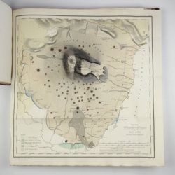
Unger, F.
Ueber den Einfluss des Bodens auf die Vertheilung der Gewächse nachgewissen in der Vegetation des nordöstlichen Tirols.
Wien, Rohrmann und Schweigerd, 1836. 8vo (21.4 x 13.5 cm). xxiv, 367 pp.; one hand-coloured engraved plate of Kitzbühl, one large, folded, hand-coloured geological-geographical map, one large, folded hand-coloured sheet with geological profile, five folded charts with meteorological observations (four) and botanical observations (one), many tables in the text. Contemporary quarter calf over marbled boards. Spine with gilt lines, vignettes, and title. Marbled endpapers; speckled edges.
Read more
Lecoq, H.
[Auvergne] Itinéraire de Clermont au Puy de Dome, ou description de cette montagne et de la Vallée de Royat et Fontanat; seconde edition. [AND] Two other papers on the geology of Auvergne, by A. C. P. F. Von Lasaulx, and by J. B. Bouillet, bound in.
Paris, J. B. Baillière, 1836. 8vo (21.2 x 13.3 cm). vi, 102 pp. Early 20th century half morocco over marbled boards. Spine with five raised bands and gilt title. Marbled endpapers.
Read more
