
Geography
42 items found

Fuchs, W.
Die Venetianer Alpen. Ein Beitrag zur Kenntniss der Hochgebirgte, met einen geognostischen Karte und Gebirgteprofilen in achtzehn Tafeln.
Solothurn, Jent & Gassmann, 1844. Oblong folio (29.8 x 35.5 cm), [4], 60 pp.; 18 mostly hand-coloured engraved maps and plates. Text pages bordered with putti and goddesses. 19th century iridescent blue blind cloth.
Read more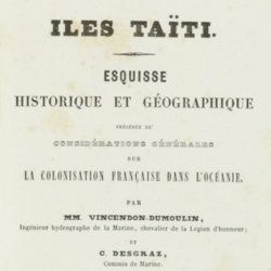
Vincendon-Dumoulin, [C. A.] and C. [L. F.] Desgraz
Iles Taïti. Esquisse historique et géographique précédée de considérations générales sur la colonisation française dans l'Océanie. Première Partie - Deuxième Partie. [Complete].
Paris, Arthus Bertrand, 1844. In two parts. 8vo (21.5 x 14.1 cm). Half-titles, title pages, 1056 pp. (pagination continuous); two large, engraved maps. Original uniform, printed wrappers.
Read more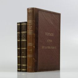
Saulcy, [L.] F. [J. C.] de
Voyage autour de la Mer Morte et dans les terres bibliques exécuté de décembre 1850 à avril 1851. Relation de voyage; atlas. [Complete].
Paris, Gide et J. Baudry, 1852-1853. In two text volumes and one atlas volume. 8vo (24.5 x 16.0 cm [text]). 1054 pp. [399; 655]). Folio/large 4to (31.0 x 23.7 cm [atlas]). 172 pp. [4, vii, 20, i-iv, 5-19; xxvi, 96]; 15 maps on 14 sheets (one double-sized); 61 (LVII; 4) lithographed plates (several tinted). Text in near contemporary uniform half calf over marbled boards. Spines with gilt bands and title; Atlas in contemporary half morocco over grained, cloth with gilt title on the front board and spine. Marbled endpapers. Original printed wrappers of the text volumes bound in.
Read more

[Geological map]
Geognostische Karte von Württemberg [AND] Begleitworte zur geognostischen Specialkarte von Württemberg.
Stuttgart, Das Königliches Statistisch-topographisches Bureau, Kohlhammer, Kleeblatt, 1863-1892. With 54 chromolithographed folded geological maps, all mounted on linen, numbered 1-48, 50-55, in two original, uniform burgundy boxes with gilt title on the lid. [AND] the "Begleitworte" 34 parts in one. Large 8vo (25.7 x 19.5 cm). Stuttgart, Königlich Statistischen Landesambt, (1865-1892). ca. 1,000 pp., and five hand-coloured wood-engraved or lithographed maps or geological profiles, and four wood-engraved plates. Contemporary half cloth over marbled boards. Spine with gilt title, ornaments, and the Württemberg coat-of-arms; patterned endpapers, and marbled edges.
Read more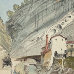
["JAM" (R. de Bouillé, Comte)]
[Original watercolour sketches of French landscapes]
[France], no place, no publisher, ca. 1863-1890. 13 oblong sheets (22.3 x 29.2 cm), all with fine watercolour paintings, either full-sized, or smaller, in a drawn rectangular frame. And one drawing on slightly smaller paper, more sketchy, in pencil.
Read more
Hochstetter, F. von and A. Petermann.
The geology of New Zealand: in explanation of the geographical and topographical atlas of New Zealand by Dr. F. Von Hochstetter and Dr. A. Petermann, from the Scientific Publications of the Novara Expedition. Translated by C. F. Fischer. Also, lectures by Dr. F. Hochstetter delivered in New Zealand.
Auckland, T. Delattre, 1864. 8vo (21.0 x 13.6 cm). Title page, 113 pp. Original grained red cloth with gilt title on the front board.
Read more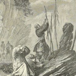
[Przewalski] Von Prschewalskij, N.
Reisen in der Mongolei, im Gebiet der Tanguten und den Wüsten Nordtibets in den Jahren 1870 bis 1873.
Jena, Hermann Costenoble, 1877. Large 8vo (21.9 x 14.1 cm). xl, 538 pp.; one coloured lithographed folding map and ten engraved plates and several text engravings. Contemporary half morocco over marbled boards. Spine with red, gilt-bordered label, title in gilt.
Read more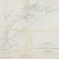
Tissot, C. [J.]
Recherches sur la géographie comparée de la Maurétanie tingitane.
Paris, Académie des Inscriptions et Belles-Lettres, 1877. 4to (27.8 x 22.1 cm). 184 pp. [numbered 139-322]; six maps and plates, including a very large, multifolded map of Morocco and adjacent areas. Original blue wrappers with printed label on the spine.
Read more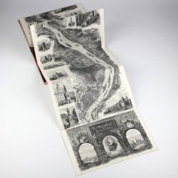
Arnold, F.
Halenza's neuestes Rhein-Panorama von Mainz bis Cöln. Einziges, durch die Berliner und Frankfurter Künstler gefässtes Urtheil, anerkanntes Kustwerk. Panorama du Rhin depuis Mayence jusq'à Cologne. Panorama of the Rhine, from Mentz to Cologne. [Complete with the rare text volume].
Mainz, J. Halenza, [1880]. Two parts in two. 8vo (text: 26.4 x 16.2 cm). Title page, 24 pp. (in English). Panorama: One folding lithographed view by F. Foltz (27 x 230 cm). Contained in original printed boards with the German title on one board, and the French/English titles on the other.
Read more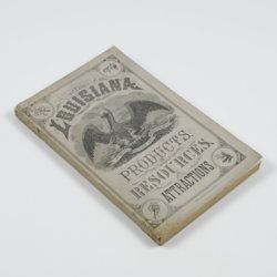
Harris, W. H.
Louisiana products, resources and attractions, with a sketch of the parishes. A hand book of reliable information concerning the State.
New Orleans, LA, W. M. Harris [for the State], 1881. 8vo (23.4 x 14.9 cm). 248 pp., one large, folded coloured map, one lithographed frontispiece portrait. Original pictorial wrappers. In protective transparent cover.
Read more
Rothpletz, A.
Ein geologischer Querschnitt durch die Ost-Alpen nebst Anhang über die sog. Glarner Doppelfalte.
Stuttgart, E. Schweizerbart (E. Koch), 1894. 8vo (22.4 x 15.4 cm). iv, 208 pp.; two full colour folded profiles of which one measuring 22.5 x 352.0 cm (!), 115 text illustrations. Contemporary half cloth over marbled boards. Gilt lines and two red morocco labels with gilt title on the spine. Edges speckled.
Read more
