
Geography
42 items found
Hochstetter, F. von and A. Petermann.
The geology of New Zealand: in explanation of the geographical and topographical atlas of New Zealand by Dr. F. Von Hochstetter and Dr. A. Petermann, from the Scientific Publications of the Novara Expedition. Translated by C. F. Fischer. Also, lectures by Dr. F. Hochstetter delivered in New Zealand.
Auckland, T. Delattre, 1864. 8vo (21.0 x 13.6 cm). Title page, 113 pp. Original grained red cloth with gilt title on the front board.
Read more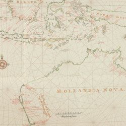
Heeres, J. E.
Het aandeel der Nederlanders in de ontdekking van Australië 1606-1765. The part borne by the Dutch in the discovery of Australia 1606-1765.
Leiden, E. J. Brill [AND] London, Luzac and Co., 1899. Large 4to (35.0 x 25.2 cm) 240 [xvii, 100 double; 101-106 single] pp., two large, folding full colour maps, 17 maps in the text. Contemporary grey buckram with gilt title on the spine. Floral-patterned endpapers.
Read more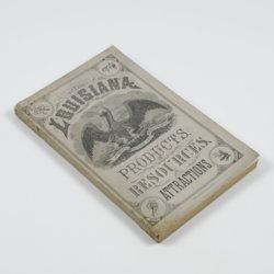
Harris, W. H.
Louisiana products, resources and attractions, with a sketch of the parishes. A hand book of reliable information concerning the State.
New Orleans, LA, W. M. Harris [for the State], 1881. 8vo (23.4 x 14.9 cm). 248 pp., one large, folded coloured map, one lithographed frontispiece portrait. Original pictorial wrappers. In protective transparent cover.
Read more
Granö, J. G.
Beiträge zur Kenntnis der Eiszeit in der Nordwestlichen Mongolei und einigen ihrer südsibirischen Grenzgebirge. Geomorphologische Studien aus den Jahren 1905, 1906, 1907 und 1909.
Helsingfors, J. Simelii [for the Geographical Society of Finland], 1910. Large 8vo (24.9 x 16.5 cm). iv, 230 pp.; seven large, folded coloured maps, 19 photographic plates. Later quarter calf over pictorial boards.
Read more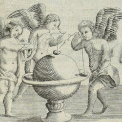
Grandami, J.
Nova demonstratio immobilitatis terrae petita ex virtut magnetica. Demonstratio immobilitatis terrae. Terra in aeternum stat. Aequivaletia longitudinum. Meridianus universalis sine declinatione.
La Flèche, George Griveau, 1645. Small 4to (20.0 x 15.3 cm). Engraved title page, [vi], 162 pp. [1-24; 33-170]; six engraved plates (of which three larger, folded), 23 (groups of) large, engraved text illustrations (some occupying a whole page), one table in the text. Early to mid-19th century polished quarter calf over marbled boards. Spine with gilt lines and ornaments, and two red morocco labels with gilt title and date. Red edges.
Read more
[Geological map]
Geognostische Karte von Württemberg [AND] Begleitworte zur geognostischen Specialkarte von Württemberg.
Stuttgart, Das Königliches Statistisch-topographisches Bureau, Kohlhammer, Kleeblatt, 1863-1892. With 54 chromolithographed folded geological maps, all mounted on linen, numbered 1-48, 50-55, in two original, uniform burgundy boxes with gilt title on the lid. [AND] the "Begleitworte" 34 parts in one. Large 8vo (25.7 x 19.5 cm). Stuttgart, Königlich Statistischen Landesambt, (1865-1892). ca. 1,000 pp., and five hand-coloured wood-engraved or lithographed maps or geological profiles, and four wood-engraved plates. Contemporary half cloth over marbled boards. Spine with gilt title, ornaments, and the Württemberg coat-of-arms; patterned endpapers, and marbled edges.
Read more
Fuchs, W.
Die Venetianer Alpen. Ein Beitrag zur Kenntniss der Hochgebirgte, met einen geognostischen Karte und Gebirgteprofilen in achtzehn Tafeln.
Solothurn, Jent & Gassmann, 1844. Oblong folio (29.8 x 35.5 cm), [4], 60 pp.; 18 mostly hand-coloured engraved maps and plates. Text pages bordered with putti and goddesses. 19th century iridescent blue blind cloth.
Read more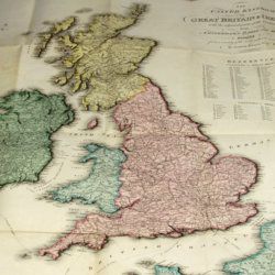
Enouy, J.
The United Kingdom of Great Britain & Ireland, with the adjacent parts of the Continent, from Amsterdam to Paris and Brest, compiled from a variety of the most authentic materials.
London, Samuel Leigh, 1818. Large, folded, coloured map (62.7 x 75.3 cm) of Great Britain and Ireland, and the continental coasts of the Channel and North Sea. In original reddish paper-covered boards, with printed label mounted.
Read more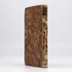
Dolomieu, D. [S. G. T.], De
Reise nach den liparischen Insuln oder Nachricht von den äolischen Insuln zur nähern Aufklärung der Geschichte der Vulkane. Nebst einer Abhandlung über eine Art von Luftvulkan, und einer andern über die Temperatur des Clima auf Maltha und die Verschiedenheit der wahren und fühlbaren Wärme.
Leipzig, Johann Gottfried Müller, 1783. 8vo (16.7 x 10.1 cm). 210, [ii] pp. Contemporary marbled boards, small leather label with gilt title on the spine. Edges yellow.
Read more
