
Geography
42 items found
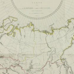
Storch, H.
Tableau historique et statistique de l'empire de Russie à fin du dix-huitième siècle. Edition française.
Basle, J. Decker, and Paris, C. Pougens, 1801. Two volumes in two. 8vo (19.6 x12.3 cm). 1,004 pp. [xxii, 407, 80; 423, 72]; two large, partly coloured folded maps (the largest with printed dimensions 67 x 36.5 cm), three folded tables. Uniform contemporary tree-calf. Spines rich gilt with gilt title on blue morocco label. Marbled endpapers. Edges yellow, speckled with red.
Read more
Radermacher, J. C. M. (ed.)
Bataviaasch Genootschap der Kunsten en Wetenschappen: Verhandelingen. Volume 1.
Batavia, Ter Lands Drukkerij, 1820. 8vo (18.6 x 12.5 cm) 266 pp., 59 pp. Voorbericht [foreword], 23 pp. Nabericht [afterword] and Bladwijzer [index]. Contemporary half calf with mottled paper over boards.
Read more
Torre, G. M. Della
Histoire et phénomènes du Vésuve. Exposés par le Pere Dom Jean-Marie Della-Torre, clerc régulier sommasque, garde bde la bibliothéque & du cabinet du roi des Deux-Siciles, & correspondant de l'Académie Royale des Sciences de Paris. Traduction de l'Italien par M. l'abbé Péton.
Paris, Jean-Thomas Hérissant, 1760. 12mo (16.3 x 9.2 cm). xxiv, 399 pp., one large folded map of Mount Vesuvius, the Bay of Naples and surroundings, and five folded plates with panoramas and other views of the volcano, caldera, etc. Contemporary full mottled calf. Spine with five raised bands. Compartments with gilt floral vignettes and small red morocco label with gilt title. Marbled endpapers, marbled edges.
Read more
Phillip, A.
Arthur Phillips Reise nach der Botany-Bay, nebst Auszügen aus den Tagebüchern der neuesten Brittischen Entdecker in der Südsee.
Hamburg, Benjamin Gottlob Hoffmann, 1791. 8vo (20.4 x 11.1 cm). [xiv], viii, [9]-264 pp.; one engraved portrait as a frontispiece, one engraved title vignette, eight engraved plates and one hand-coloured folded map. Contemporary mottled half calf over marbled boards. reen moroccolabel with gilt title on the spine. Blue endpapers.
Read more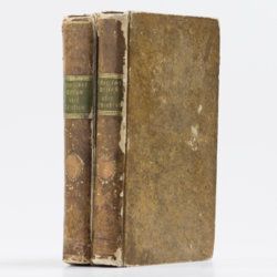
Le Goux de Flaix, A. [Legoux]
Historisch-geographisch politischer Versuch über Ostindien nebst der Schilderung von dessen Handel nach Le Goux de Flaix. Mit Noten, Anmerkungen und einer Vorrede von E. A. W. v. Z[immermann].
Leipzig, Heinrich Gräff, 1810. Two volumes in two. 8vo (17.5 x 10.7 cm). 892 [I: viii, 444; II: iv, 436] pp.; one folded engraving of the Jagannath temple. Contemporary uniform tree calf resembling paper boards with ruled borders, olive and brown gilt-lettered morocco labels on spines.
Read more
Allemann, F.
Geologische Karte Fürstentum Liechtenstein.
[Vaduz], Regierung des Fürstentums Liechtenstein, 1953. Large (102.0 x 67.0 cm), folded map, consisting of 25 rectangular sheets in full colour, mounted on linen. Handwritten and stamped label on the front-facing part of the linen map verso.
Read more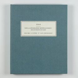
Cuvier, G. and A. [T.] Brongniart
Essai sur la géographie minéralogique des environs de Paris. Proof copy of the introductions, with corrections by Brogniart.
Paris, Institut Impériale de France, [1809 or 1810]. 4to (25.0 x 20.0 cm). 33 pp. Not bound. In a 20th century blue hardcover paper drop-box (26.8 x 22.0 cm) with printed label on the top board.
Read more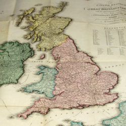
Enouy, J.
The United Kingdom of Great Britain & Ireland, with the adjacent parts of the Continent, from Amsterdam to Paris and Brest, compiled from a variety of the most authentic materials.
London, Samuel Leigh, 1818. Large, folded, coloured map (62.7 x 75.3 cm) of Great Britain and Ireland, and the continental coasts of the Channel and North Sea. In original reddish paper-covered boards, with printed label mounted.
Read more
Rothpletz, A.
Ein geologischer Querschnitt durch die Ost-Alpen nebst Anhang über die sog. Glarner Doppelfalte.
Stuttgart, E. Schweizerbart (E. Koch), 1894. 8vo (22.4 x 15.4 cm). iv, 208 pp.; two full colour folded profiles of which one measuring 22.5 x 352.0 cm (!), 115 text illustrations. Contemporary half cloth over marbled boards. Gilt lines and two red morocco labels with gilt title on the spine. Edges speckled.
Read more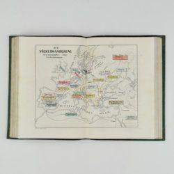
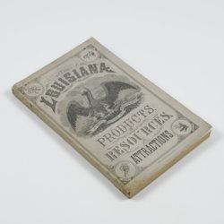
Harris, W. H.
Louisiana products, resources and attractions, with a sketch of the parishes. A hand book of reliable information concerning the State.
New Orleans, LA, W. M. Harris [for the State], 1881. 8vo (23.4 x 14.9 cm). 248 pp., one large, folded coloured map, one lithographed frontispiece portrait. Original pictorial wrappers. In protective transparent cover.
Read more
Hochstetter, F. von and A. Petermann.
The geology of New Zealand: in explanation of the geographical and topographical atlas of New Zealand by Dr. F. Von Hochstetter and Dr. A. Petermann, from the Scientific Publications of the Novara Expedition. Translated by C. F. Fischer. Also, lectures by Dr. F. Hochstetter delivered in New Zealand.
Auckland, T. Delattre, 1864. 8vo (21.0 x 13.6 cm). Title page, 113 pp. Original grained red cloth with gilt title on the front board.
Read more
