
Geography
42 items found
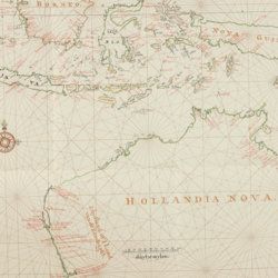
Heeres, J. E.
Het aandeel der Nederlanders in de ontdekking van Australië 1606-1765. The part borne by the Dutch in the discovery of Australia 1606-1765.
Leiden, E. J. Brill [AND] London, Luzac and Co., 1899. Large 4to (35.0 x 25.2 cm) 240 [xvii, 100 double; 101-106 single] pp., two large, folding full colour maps, 17 maps in the text. Contemporary grey buckram with gilt title on the spine. Floral-patterned endpapers.
Read more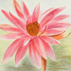
Lovassy, A.
Resultate der wissenschaftlichen Erforschung des Balatonsees. Mit Unterstützung der hohen Kön. Ung. Ministerien für Ackerbau und für Cultus und Unterricht. Zweiter Band. Die Biologie des Balatonsees und seiner Umgebung. Zweiter Theil. Die Flora. II. Sektion. Die Pflanzengeographischen Verhältnisse der Balatonsee-Gegend. Anhang. Die trophischen Nymphaeen des Hévizsees bei Keszthely.
Wien, Ed. Hölzel, 1909. Large 4to (29.3 x 21.2 cm). 91 pp.; four plates of which three in chromolithography. Original printed wrappers.
Read more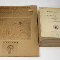
Willis, B. (ed.)
Research in China. In three volumes and atlas. 1(1). Descriptive topography and geology; 1(2). Petrography and zoology; 2. Systematic geology; 3. The Cambrian faunas of China. A report on Ordovician fossils collected in eastern Asia in 1903-04. A report on Upper Paleozoic fossils collected in China 1903-04; [4.] Geographical and geological maps. [Complete].
Washington, DC, The Carnegie Institution of Washington, 1907-1913. In five parts (four text and plate volumes, one atlas). 4to (29.8 x 24.0 cm). Text; 101 plates, including six chromolithographs of birds, and geological maps; folio atlas (52.7 x 45.0 cm) with 42 mostly coloured geological and topographical maps (some with explanatory text or figures). Original printed wrappers.
Read more
Granö, J. G.
Beiträge zur Kenntnis der Eiszeit in der Nordwestlichen Mongolei und einigen ihrer südsibirischen Grenzgebirge. Geomorphologische Studien aus den Jahren 1905, 1906, 1907 und 1909.
Helsingfors, J. Simelii [for the Geographical Society of Finland], 1910. Large 8vo (24.9 x 16.5 cm). iv, 230 pp.; seven large, folded coloured maps, 19 photographic plates. Later quarter calf over pictorial boards.
Read more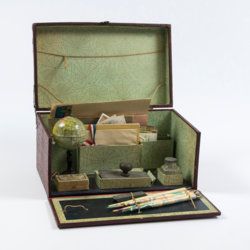
Travelling writer's kit
Travelling writer's kit with stationery and miniature globe.
Paris, ca. 1915-1925. Portable red cardboard box (28.0 x 16.9 x 14.3 cm) embossed with maroon reptile-skin patterned paper with gilt title "Papeterie" and vignette, and simple brass lock. Inside covered with decorative green-with-black-cobweb patterned paper.
Read more
Allemann, F.
Geologische Karte Fürstentum Liechtenstein.
[Vaduz], Regierung des Fürstentums Liechtenstein, 1953. Large (102.0 x 67.0 cm), folded map, consisting of 25 rectangular sheets in full colour, mounted on linen. Handwritten and stamped label on the front-facing part of the linen map verso.
Read more
