
Geography
42 items found
Arnold, F.
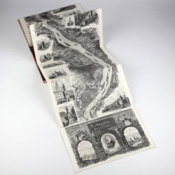
Halenza's neuestes Rhein-Panorama von Mainz bis Cöln. Einziges, durch die Berliner und Frankfurter Künstler gefässtes Urtheil, anerkanntes Kustwerk. Panorama du Rhin depuis Mayence jusq'à Cologne. Panorama of the Rhine, from Mentz to Cologne. [Complete with the rare text volume].
Mainz, J. Halenza, [1880]. Two parts in two. 8vo (text: 26.4 x 16.2 cm). Title page, 24 pp. (in English). Panorama: One folding lithographed view by F. Foltz (27 x 230 cm). Contained in original printed boards with the German title on one board, and the French/English titles on the other.
Read more
Granö, J. G.
Beiträge zur Kenntnis der Eiszeit in der Nordwestlichen Mongolei und einigen ihrer südsibirischen Grenzgebirge. Geomorphologische Studien aus den Jahren 1905, 1906, 1907 und 1909.
Helsingfors, J. Simelii [for the Geographical Society of Finland], 1910. Large 8vo (24.9 x 16.5 cm). iv, 230 pp.; seven large, folded coloured maps, 19 photographic plates. Later quarter calf over pictorial boards.
Read more
Lovassy, A.
Resultate der wissenschaftlichen Erforschung des Balatonsees. Mit Unterstützung der hohen Kön. Ung. Ministerien für Ackerbau und für Cultus und Unterricht. Zweiter Band. Die Biologie des Balatonsees und seiner Umgebung. Zweiter Theil. Die Flora. II. Sektion. Die Pflanzengeographischen Verhältnisse der Balatonsee-Gegend. Anhang. Die trophischen Nymphaeen des Hévizsees bei Keszthely.
Wien, Ed. Hölzel, 1909. Large 4to (29.3 x 21.2 cm). 91 pp.; four plates of which three in chromolithography. Original printed wrappers.
Read more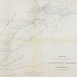
Tissot, C. [J.]
Recherches sur la géographie comparée de la Maurétanie tingitane.
Paris, Académie des Inscriptions et Belles-Lettres, 1877. 4to (27.8 x 22.1 cm). 184 pp. [numbered 139-322]; six maps and plates, including a very large, multifolded map of Morocco and adjacent areas. Original blue wrappers with printed label on the spine.
Read more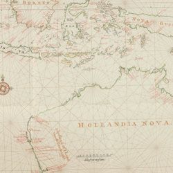
Heeres, J. E.
Het aandeel der Nederlanders in de ontdekking van Australië 1606-1765. The part borne by the Dutch in the discovery of Australia 1606-1765.
Leiden, E. J. Brill [AND] London, Luzac and Co., 1899. Large 4to (35.0 x 25.2 cm) 240 [xvii, 100 double; 101-106 single] pp., two large, folding full colour maps, 17 maps in the text. Contemporary grey buckram with gilt title on the spine. Floral-patterned endpapers.
Read more
