
Asia
104 items found

[Games]
Eight Topographical Puzzles.
Paris, Librairie Hachette, no date (ca. 1890). A set of eight coloured topographical puzzles, showing the different continents. The puzzles are maps, mounted on wood, each divided into 42 pieces. The edges are covered with gilt paper. In the original paper & cloth box (35.5 x 26.9 x 5.0 cm), with a map of the world mounted on the lid. Inside of the box covered with light blue paper.
Read more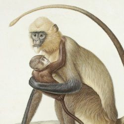

Granö, J. G.
Beiträge zur Kenntnis der Eiszeit in der Nordwestlichen Mongolei und einigen ihrer südsibirischen Grenzgebirge. Geomorphologische Studien aus den Jahren 1905, 1906, 1907 und 1909.
Helsingfors, J. Simelii [for the Geographical Society of Finland], 1910. Large 8vo (24.9 x 16.5 cm). iv, 230 pp.; seven large, folded coloured maps, 19 photographic plates. Later quarter calf over pictorial boards.
Read more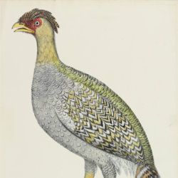
Gray, J. E.
Blackheaded pheasant. Female [From: Illustrations of Indian Zoology. Chiefly selected from the collection of Major-General Hardwicke. F.R.S.].
London, Treuttel, Wurtz, Treuttel, jun. and Richter, 1831-1832. Folio (46.3 x 33.1 cm). Fine lithographed plate with original hand-colouring.
Read more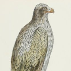
Gray, J. E.
Lined fishing eagle [From: Illustrations of Indian Zoology. Chiefly selected from the collection of Major-General Hardwicke F. R. S.].
London, Treuttel, Wurtz, Treuttel, jun. and Richter, 1831. Folio (46.5 x 33.2 cm). Fine lithographed plate with original hand-colouring.
Read more
Guettard, J. E.
Histoire de l'Academie Royale des sciences, Année MDCCLI [1751], avec les mémoires de mathématique & de physique, pour la même année. Tirés des registres de cette académie.
Paris, l'Imprimerie Royale, 1755. 4to (25.1 x 18.9 cm). 738 [202, 536] pp.; 23 mostly large, folded plates. Contemporary full tree-calf. Spine with five raised bands, gilt title and gilt vignettes. Marbled endpapers. Red edges.
Read more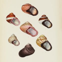
Hanley, S. [C. T.] and W. Theobald
Conchologia Indica: illustrations of the land and freshwater shells of British India.
London, L. Reeve, [1870]-1876. 4to (27.2 x 20.8 cm). xviii, 65 pp.; 160 hand-coloured, lithographed plates. 20th-century dark green buckram. Gilt title on the spine.
Read more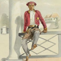
Hardouin, E. and W. L. Ritter
Java. Tooneelen uit het leven. Karakterschetsen en kleederdragten van Java's bewoners in afbeeldingen naar de natuur geteekend door E. Hardouin met tekst van W. L. Ritter en een voorwoord van H. M. Lange, gepensionneerd Luitenant Kolonel van het O. I. leger. Benevens eene kaart van Java naar de nieuwste bronnen bewerkt.
Leiden, A. W. Sythoff, 1855. Large 4to (28.7 x 20.7 cm). Title page with finely engraved vignette; xv, 242 pp.; hand-coloured lithographed frontispiece and 25 other hand-coloured lithographed and tissue-guarded plates; large, triple-folded coloured double map of Java, Madoera and Bawean. Original green embossed cloth. Spine and front board rich gilt with floral patterns and ethnographical vignettes. Yellow endpapers. All edges gilt.
Read more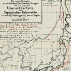
Haushofer, K.
Der deutsche Anteil und der geographischen Erschließung Japans und des Subjapanischen Erdraums, und deren Förderung durch den Einfluß von Krieg und Wehrpolitik.
Erlangen, Junge & Sohn, 1914. 8vo (24.2 x 16.0 cm). 110 pp., two folded maps, several text figures and maps. Original printed wrappers.
Read more
