Europe
362 items found
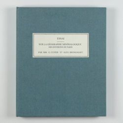
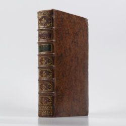
Cuvier, G. and A. [T.] Brongniart
Essai sur la géographie minéralogique des environs de Paris. Proof copy of the introductions, with corrections by Brogniart.
Paris, Institut Impériale de France, [1809 or 1810]. 4to (25.0 x 20.0 cm). 33 pp. Not bound. In a 20th century blue hardcover paper drop-box (26.8 x 22.0 cm) with printed label on the top board.
Read more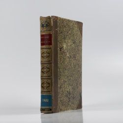
Cuvier, G. [L. C. F. D.] and A. Brongniart
Description géologique des environs de Paris, par MM. G. Cuvier et Alex. Brongniart. Nouvelle édition, dans laquelle on a inséré la descrition d'un grand nombre de lieux de l'Allemagne, de la Suisse, de l'Italie, etc., qui présentent des terrains analogues a ceux du Bassin de Paris. Avec 2 cartes et 16 planches représentant les coupes de ces terrains et beaucoup des coquilles fossiles qu'ils renferment, et une table alphabétique de tous les lieux décrits ou seulement cités.
Paris, G. Dufour et E. d'Ocagne, 1822. 4to (29.3 x 22.2 cm). ix, 428 pp.; one brightly hand-coloured geological map of the surroundings of Paris, and 17 lithographed plates, including one hand-coloured geological map of the basins of London and Paris. Contemporary half calf over marbled boards. Spine with five raised, gilt-ornamented bands; compartments rich gilt, and with two morocco labels (red and blue) with gilt title.
Read more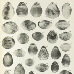
Davidson, T.
A monograph of British Cretaceous Brachiopoda. [AND] M. R. Sahni, the Terebratulidae of the British Chalk. [AND] N. E. Pettitt, The Rhynchonellidae of the British Chalk.
London, The Palaeontographical Society, 1854-1953. 4to (27.0 x 20.6 cm). 205 pp., 21 [12, 9] lithographed plates; 62 pp.; ten plates; 58 pp., three plates. Later half calf, spine with five raised, gilt bordered bands, and gilt titles on spine. Edges speckled red.
Read more
Devèze de Chabrol, J. S. and J. B. Bouillet
Essai géologique et minéralogique sur les environs d'Issoire, département du Puy-de-Dôme, et principalement sur la Montagne de Boulade.
Clermont-Ferrand, Thibaud-Landriot, 1827. Folio (41.0 x 26.2 cm). xii, 104 pp.;hand-coloured lithographed geological map and hand-coloured profile, and 30 lithographed plates depicting vertebrates and several tables, including one very large, folded in the text. Contemporary half morocco over marbled boards. Spine with gilt lines and title. Marbled endpapers; speckled edges.
Read more
[Dezallier d'Argenville, A. J. D.]
l'Histoire naturelle éclaircie dans une de ses parties principales, l'Oryctologie, qui traite des terres, des pierres, des métaux, des minéraux, et autres fossiles. Ouvrage dans lequel on trouve une nouvelle méthode Latine & Françoise de les diviser, & une notice critique des principaux ouvrages qui ont paru sur ces matières.
Paris, De Bure, 1755. 4to (28.6 x 21.1 cm). Engraved frontispiece, [6], xvi, 560 [1] pp.; 26 engraved plates. Contemporary full mottled calf, richly floral gilt spine with five raised bands and gilt lettered red morocco label. Marbled endpapers, edged red.
Read more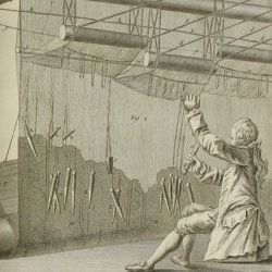
Diderot, D. and J. d'Alembert (eds.)
[Dictionnaire des sciences, des arts et des métiers, par une société de gens de lettres. Mis en ordre et publié par M***]. Recueil des planches, sur les sciences et les arts. Tome I.
Paris, Briasson, etc. 1762. Folio (39.5 x 25.3 cm). Letterpress half title, title page with engraved vignette, text and 269 plates. Contemporary uniform full calf. Spines wih six raised bands, rich gilt compartments and gilt titles. Marbled endpapers. Red edges.
Read more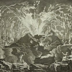
Diderot, D. and J. d'Alembert (eds.)
Encyclopédie ou dictionnaire raisonné des sciences, des arts et des métiers, par une société de gens de lettres mis en ordre par Mons. Diderot. Histoire naturelle. Règne mineral.
Paris, Diderot et d'Alembert, 1768. Folio (43.2 x 27.2 cm). 4 pp., 130 plates (partly folded). Disbound.
Read more
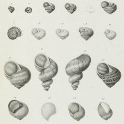
Draparnaud, J. P. R. and A. L. G. Michaud
Histoire naturelle des mollusques terrestres et fluviatiles de la France. Ouvrage posthume de J. P. R. Draparnaud. Avec XIII planches. [AND] Complément de l'histoire naturelle des mollusques terrestres et fluviatiles de la France, de J. P. R. Draparnaud. Avec planches.
Paris, Louis Colas, an 13 [1805]; Verdun, Lippmann, 1831. Two works in one. 4to (28.8 x 23.0 cm). Half-titles and titles; viii, 164; xvi, 116, 12 pp.; 16 [13, 3] engraved plates. Brown buckram with gilt titles on the spine.
Read more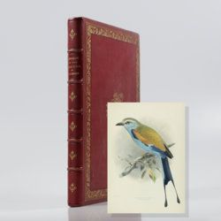
Dresser, H. E.
A monograph of the Coraciidae or family of the rollers.
Farnborough, the author, 1893. Folio (37.6 x 28.3 cm). Title page with woodcut vignette (owl) and quote in Greek; xx, 111; 27 lithographed plates, all in a most careful and beautiful original hand-colouring. Contemporary full red pebbled morocco. Spine with five raised, gilt-stippled bands; compartments with central gilt vignettes and title. Boards with intricate gilt floral borders and woodcut vignette (an owl - as on the title page), bevelled edges, gilt inner dentelles. Marbled endpapers. Top edge gilt.
Read more
Dufrenoy, [O. P. A.] and [J. B. A. L. L.] Élie de Beaumont
Explication de la carte géologique de la France. Volumes I-IV (text and atlas), and two maps. [Complete].
Paris, Imprimerie Royale, Imprimerie Nationale, 1841-1879. Four volumes in seven, and a large map in six folded sheets, each ca. 70 x 205 cm (including borders) with linen covers. Large 4to (four text volumes; ca. 27.5 x 21.0 cm); folio (two atlas volumes, 26.8 x 35.7 cm). Tome premier: Paris, Imprimerie Royale, 1841. Large 4to. xxii, 825 pp., 71 text engravings (mainly profiles); Tome deuxième: Paris, Imprimerie Nationale, 1848. Large 4to. xii, 813 pp., 105 text engravings (mainly views and profiles), one large, folded chromolithographed geological map (finished by hand) of France (printed surface: 57 x 54 cm, and consisting of 15 smaller sections, mounted on linen and folded) bound in the rear; Tome troisième. Première partie (by Dufrénoy): Paris, Imprimerie Nationale, 1873. Large 4to. viii, 231 pp., 18 text engravings (mainly profiles). Printed wrappers. Tome quatrième. Seconde partie. Végétaux fossiles du terrain houiller (by Zeiller): Paris, Imprimerie Nationale, 1879. Large 4to. 185 pp. Printed wrappers; Tome quatrième. Atlas (in two volumes). Première partie. Fossiles principaux des terrains (by É. Bayle). Seconde partie. Végétaux fossiles du terrain houiller (by Zeiller): Paris, Imprimerie Nationale, 1878. Folio. Title page, half title to first part. 86 lithographed plates with explanatory text leaves, numbered I-LXXXVI; 90 lithographed plates with explanatory text leaves, numbered LXXXVII-CLXXVI (the last 16 on plants), for a total of 176 plates. Volumes I, II, and IV plate volumes in near uniform contemporary dark-green pebbled morocco over marbled boards. Spines with five gilt-stippled bands, and gilt title. Marbled endpapers. The text volumes with top edge gilt, atlases with marbled top edges. Text volumes III and IV in original printed wrappers. The large chromolithographed map in six sheets (approximately 218 x 223 cm) is contained in a contemporary, book-like crimson box with gilt-lettered spine, with raised bands and patterned paper sides.
Read more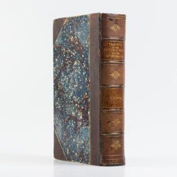
Duppa, R.
Travels on the continent, Sicily and the Lipari Islands. Second edition.
London, Longman, Rees, Orme, and Co., 1829. Large 8vo (26.8 x 17.2 cm). x, 494, [ii] pp.; 21 fine engraved plates, and 34 text engravings. Contemporary grained half morocco over marbled boards. Spine with five raised, stipple-gilted bands; compartments with gilt vignettes and a brown morocco label with gilt title.
Read more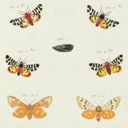
Engramelle, M. and J. Ernst
Papillons d'Europe, peints d'apres nature par M. Ernst gravés et coloriés sous sa direction. [Unpublished supplement plates].
Paris, Unpublished (printed and coloured 1792-1793). 4to (30.5 x 24.0 cm). Being: Sup. Cl. Ire (supplement, classe I), beautifully hand-coloured engraving 1-5, 7-9 with 84 figures. numbered n, m: 172 a-d, f-i bis; 173e; 174 a-d bis; 178 i, k-l; 186 i, k (2x), l; 187 a-d bis and gg, hh, ii, kk; 194 i; 195 a-f bis; 201 k; 207 h; 208 c-f; 215 d; 217 h; 218 h-i; 228 c-e; 237 a-b bis; 242 a-d bis; 256 d; 245 i, k; 246 m; 258 a-c bis; 261 g; 262 a-d bis; 254 c-e; 257 bis; 263 a-b bis; 276 h-i; 278 a-c bis; 280 a-c bis; all engraved by A. Schmidt and painted by M. Hochecker. In new marbled portfolio.
Read more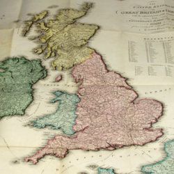
Enouy, J.
The United Kingdom of Great Britain & Ireland, with the adjacent parts of the Continent, from Amsterdam to Paris and Brest, compiled from a variety of the most authentic materials.
London, Samuel Leigh, 1818. Large, folded, coloured map (62.7 x 75.3 cm) of Great Britain and Ireland, and the continental coasts of the Channel and North Sea. In original reddish paper-covered boards, with printed label mounted.
Read more