
Regional Earth Sciences - Geology
69 items found
Tokunaga, S. et al.
Report of the First Scientific Expedition to Manchoukuo. Under the leadership of Shigeyasu Tokunaka. June - October 1933. Section II [Geology]. Part I-IV. [Complete].
Tokyo, Asahi, 1934-1939. Four volumes in four. 4to (26.0 x 19.0 cm). Ca. 700 pp. with 124 plates and three folding coloured maps. Original uniform printed stiff wrappers.
Read more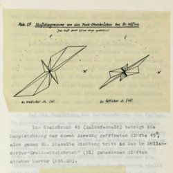
Tollmann, A.
Das Neogen am Südwestrand des Leithagebirges zwischen Eisenstadt und Hornstein. Dissertation zur Erlangung des Doktorgrades an der Philosophischen Fakultät der Universität Wien.
Wien, [not published], 1953. Small folio (29.8 x 21.0 cm). 226 pp.; 28 text figures (tipped in), three large folded maps (one hand-coloured), five folded tables and graphs. Black half cloth. Hand-written label on the spine.
Read more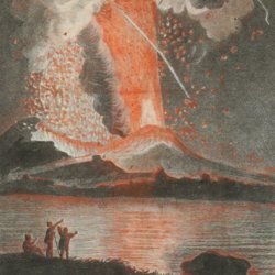
Torcia, M.
Relazione dell'ultima eruzione del Vesuvio. Accaduta nel mese di agosto di questo anno 1779. Rélation de la dernière éruption du Vésuve. Arrivée au mois d'Août de cette année 1779.
Napoli, Raimondi, 1779. 8vo (18.6 x 12.0 cm). Two title pages (Italian and French) with different engraved vignettes, [vi], 135 pp. (separated by a blank page), one folded engraved view of the eruption engraved by Boilly and nicely hand-coloured by Volaire. Contemporary vellum. Spine with gilt-lettered label.
Read more
Torre, G. M. Della
Histoire et phénomènes du Vésuve. Exposés par le Pere Dom Jean-Marie Della-Torre, clerc régulier sommasque, garde bde la bibliothéque & du cabinet du roi des Deux-Siciles, & correspondant de l'Académie Royale des Sciences de Paris. Traduction de l'Italien par M. l'abbé Péton.
Paris, Jean-Thomas Hérissant, 1760. 12mo (16.3 x 9.2 cm). xxiv, 399 pp., one large folded map of Mount Vesuvius, the Bay of Naples and surroundings, and five folded plates with panoramas and other views of the volcano, caldera, etc. Contemporary full mottled calf. Spine with five raised bands. Compartments with gilt floral vignettes and small red morocco label with gilt title. Marbled endpapers, marbled edges.
Read more
Unger, F.
Ueber den Einfluss des Bodens auf die Vertheilung der Gewächse nachgewissen in der Vegetation des nordöstlichen Tirols.
Wien, Rohrmann und Schweigerd, 1836. 8vo (21.4 x 13.5 cm). xxiv, 367 pp.; one hand-coloured engraved plate of Kitzbühl, one large, folded, hand-coloured geological-geographical map, one large, folded hand-coloured sheet with geological profile, five folded charts with meteorological observations (four) and botanical observations (one), many tables in the text. Contemporary quarter calf over marbled boards. Spine with gilt lines, vignettes, and title. Marbled endpapers; speckled edges.
Read more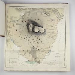
[Various authors]
Annales des Mines. Series III-VI. Atlases.
Paris, Ecole de Mines, 1832-1866. Two series in four. Oblong folio (40.5 x 22.0 cm) with 758 (of 759? see below) engraved and lithographed plates and maps, of which 29 are hand-coloured geological maps or profiles. Contemporary uniform red cloth. Gilt titles on the spines and front boards. Marbled endpapers.
Read more
[Various geologists and palaeontologists]
Mémoires de la Société Linnéenne de Normandie. Volumes I-V. [IINCLUDING Société Linnéenne de Calvados].
Caen, Société Linnéenne de Normandie, 1824-1835. Five volumes in six. 8vo (volumes I-IV, 21.0 x 13.2 cm), 4to (volume V, 27.6 x 22.0 cm), and oblong folio (atlas to volumes II-IV, 22.5 x 31.0 cm). Title pages; 15 lithographed (partly folded) plates in volume I, one hand-coloured geological map, 39 lithographed plates in the atlas volume, mainly depicting lichens by Delise, and geological maps (11 hand-coloured). Uniform later half calf over marbled boards. Spines with gilt title.
Read more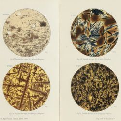
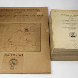
Willis, B. (ed.)
Research in China. In three volumes and atlas. 1(1). Descriptive topography and geology; 1(2). Petrography and zoology; 2. Systematic geology; 3. The Cambrian faunas of China. A report on Ordovician fossils collected in eastern Asia in 1903-04. A report on Upper Paleozoic fossils collected in China 1903-04; [4.] Geographical and geological maps. [Complete].
Washington, DC, The Carnegie Institution of Washington, 1907-1913. In five parts (four text and plate volumes, one atlas). 4to (29.8 x 24.0 cm). Text; 101 plates, including six chromolithographs of birds, and geological maps; folio atlas (52.7 x 45.0 cm) with 42 mostly coloured geological and topographical maps (some with explanatory text or figures). Original printed wrappers.
Read more
