
Regional Earth Sciences - Geology
69 items found
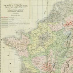
Beche, H. de la
A selection of the Geological Memoirs, contained in the Annales des Mines, together with a synoptical table of equivalent formations and Brongniart's table of the classification of mixed rocks. Translated with notes by H. T. de la Beche, Esq.
London, William Phillips, 1824. 8vo (21.1 x 13.3 cm). xxii, 335 pp.; one hand-coloured folded geological map of France and the Netherlands including a great part of Germany, the Alps and northern Italy, by J. d'Omalius d'Halloy (numbered plate 11 [not II]) and two further hand-coloured geological maps or profiles (numbered I-II), eight folded lithographed plates (numbered III-X), including a very fine view of the coalmine at Treuil near St. Etienne, one folding table. Contemporary half calf over marbled boards. Spine with gilt lines and title. Edges speckled red.
Read more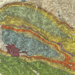
Carez, L. [L. H.]
La géologie des Pyrénées Françaises.
Paris, Imprimerie Nationale, 1903-1909. In six volumes, including the supplement. Large 4to (29.5 x 22.6 cm). 3,908 [ix, 3,899] pp.; 39 mainly geological folded maps or profiles (six in full-colour), and heliogravures (photogravures), some with printed overlays. Uniform contemporary half calf over marbled boards. Spines with four raised bands and gilt title.
Read more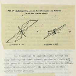
Tollmann, A.
Das Neogen am Südwestrand des Leithagebirges zwischen Eisenstadt und Hornstein. Dissertation zur Erlangung des Doktorgrades an der Philosophischen Fakultät der Universität Wien.
Wien, [not published], 1953. Small folio (29.8 x 21.0 cm). 226 pp.; 28 text figures (tipped in), three large folded maps (one hand-coloured), five folded tables and graphs. Black half cloth. Hand-written label on the spine.
Read more
Bourrit, M. T.
Description des Alpes, Pennines et Rhetiennes; dédiée a.s.m. très-chrétienne Louis XVI, roi de France et de Navarre. Tome premier - second. [Complete].
Genève, J. P. Bonnant, 1781. In two volumes. 8vo (21.5 x 13.8 cm). xix, 247 pp.; [ii], 285 pp.; eight engraved plates, mainly of glaciers, and one folded engraved map of the Alps, several wood engraved vignettes in the text. Original uniform blind publishers' wrappers. Spines renewed with later printed labels. Contained in a later blue cloth slipcase (23.2 x 15.8 x 6.9 cm) with black morocco label with gilt title.
Read more
Mille, M. et al.
Contrôle des Chemins de Fer. Ligne de Paris à Brest. Réseau d'Orléans. Profil géologique suivant le tracé du chemin de fer dressé sur les indications de M.M. Triger et Delesse. Notice par M. Mille ingénieur en Chef des Ponts et Chaussées 1867.
Paris, Jules Bonaventure, 1866-1867. In four parts. 4to. Title-page, 9 pp. (text volume); one folded, chromolithographed profile (31.0 x 99.8 cm), titled: Coupe des huillères de Chalonnes d'après les travaux des ingénieurs de la mine; one very long folded profile (31 x 957 cm, including title and legend) titled: Section de Paris à Angers par Vendôme et Tours; a second very long folded chromolithographed profile (31 x 1147 [!] cm), title: Section de Angers à Brest par Nantes et Chateaulin. All four contained in a blind stamped cloth portfolio with gilt title on the spine and top board.
Read more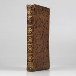
Hamilton, W.
Voyage à la cote septentrionale du Comté d'Antrim en Irlande, et à l'ile de Raghery, contenant l'histoire naturelle de ses productions volcaniques & plusieurs observations sur les antiquités & moeurs de ce pays... auquel on a ajouté l'essai sur l'oryctographie du Derbyshire par M. Ferber, traduit de l'Allemand.
Paris, Cuchet, 1790. 8vo (19.6 x 12.5 cm). viii, 239 pp.; engraved folding plate showing several geological layers of Derbyshire. Contemporary full mottled calf. Spine rich gilt with floral vignettes, small red morocco label with gilt title. Marbled endpapers, red edges.
Read more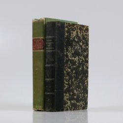
Palassou, P. B.
Mémoires pour servir à l'histoire naturelle des Pyrénées, et des pays adjacens. [AND] Suite des mémoires pour servir à l'histoire naturelle des Pyrénées, et des pays adjacens.
Pau, Vignancour, 1815-1819. Two volumes in two (20.7 x 12.7; 19.6 x 12.0 cm). 8vo. 954 pp. [xvi, 485; xxiii, 430]. Contemporary green boards. Spine with gilt bands and red morocco label with gilt title (volume I), and near contemporary half calf over marbled boards. Spine with five raised bands and gilt title. Marbled endpapers (volume II).
Read more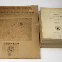
Willis, B. (ed.)
Research in China. In three volumes and atlas. 1(1). Descriptive topography and geology; 1(2). Petrography and zoology; 2. Systematic geology; 3. The Cambrian faunas of China. A report on Ordovician fossils collected in eastern Asia in 1903-04. A report on Upper Paleozoic fossils collected in China 1903-04; [4.] Geographical and geological maps. [Complete].
Washington, DC, The Carnegie Institution of Washington, 1907-1913. In five parts (four text and plate volumes, one atlas). 4to (29.8 x 24.0 cm). Text; 101 plates, including six chromolithographs of birds, and geological maps; folio atlas (52.7 x 45.0 cm) with 42 mostly coloured geological and topographical maps (some with explanatory text or figures). Original printed wrappers.
Read more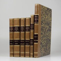
[Various geologists and palaeontologists]
Mémoires de la Société Linnéenne de Normandie. Volumes I-V. [IINCLUDING Société Linnéenne de Calvados].
Caen, Société Linnéenne de Normandie, 1824-1835. Five volumes in six. 8vo (volumes I-IV, 21.0 x 13.2 cm), 4to (volume V, 27.6 x 22.0 cm), and oblong folio (atlas to volumes II-IV, 22.5 x 31.0 cm). Title pages; 15 lithographed (partly folded) plates in volume I, one hand-coloured geological map, 39 lithographed plates in the atlas volume, mainly depicting lichens by Delise, and geological maps (11 hand-coloured). Uniform later half calf over marbled boards. Spines with gilt title.
Read more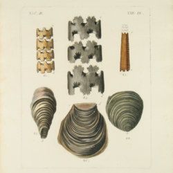
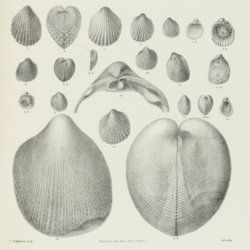
Stoliczka, F.
Palaeontologia Indica, being figures and descriptions of the organic remains procured during the progress of the geological survey of India. Vol. III. The Pelecypoda, with a review of all known genera of this class, fossil and recent.
Calcutta, Geological Survey Office, 1871. Folio (37.0 x 25.1 cm). Title page, xxii, 538 pp.; 50 lithographed plates with explanatory text leaves. Near-contemporary half calf with blind-tooled borders over pebbled boards. Spine with gilt lines, and two red morocco labels with gilt title.
Read more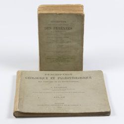
Leymerie, A. [F. G. A.]
Description géologique et paléontologique des Pyrenées de la Haute-Garonne accompagnée d'une carte topographique et géologique à l'echelle 1:200.000 et d'un Atlas...
Toulouse, Privat, 1878, 1881. In two volumes. Text (1881) 8vo (24.0 x 16.0 cm). Atlas (1878) oblong 4to (23.5 x 31.5 cm). 1,027 pp.; 51 lithographed plates of which 11 tinted or coloured (and of which 30 are on fossils), including a large folded transection of the Pyrenees, Haute Garonne, and the large coloured geological map (with 20 colours) mounted on linen. Original printed wrappers (text) and boards (atlas).
Read more
