
Regional Earth Sciences - Geology
69 items found
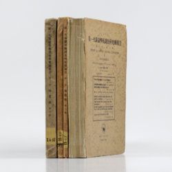
Tokunaga, S. et al.
Report of the First Scientific Expedition to Manchoukuo. Under the leadership of Shigeyasu Tokunaka. June - October 1933. Section II [Geology]. Part I-IV. [Complete].
Tokyo, Asahi, 1934-1939. Four volumes in four. 4to (26.0 x 19.0 cm). Ca. 700 pp. with 124 plates and three folding coloured maps. Original uniform printed stiff wrappers.
Read more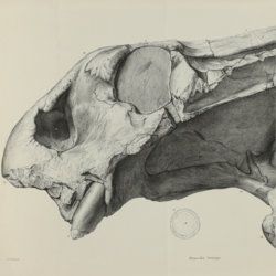
Owen, R.
Descriptive and illustrated catalogue of the fossil Reptilia of South Africa in the collection of the British Museum.
London, The Trustees of the British Museum, 1876. Folio (32.5 x 25.2 cm). xii, 88 pp.; 70 fine lithographed plates, several larger, and folded. Original green pebbled and blind-tooled cloth. Gilt title on the spine.
Read more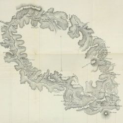
Dolomieu, D. [S. G. T.], De
Reise nach den liparischen Insuln oder Nachricht von den äolischen Insuln zur nähern Aufklärung der Geschichte der Vulkane. Nebst einer Abhandlung über eine Art von Luftvulkan, und einer andern über die Temperatur des Clima auf Maltha und die Verschiedenheit der wahren und fühlbaren Wärme.
Leipzig, Johann Gottfried Müller, 1783. 8vo (16.7 x 10.1 cm). 210, [ii] pp. Contemporary marbled boards, small leather label with gilt title on the spine. Edges yellow.
Read more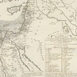
Guettard, J. E.
Histoire de l'Academie Royale des sciences, Année MDCCLI [1751], avec les mémoires de mathématique & de physique, pour la même année. Tirés des registres de cette académie.
Paris, l'Imprimerie Royale, 1755. 4to (25.1 x 18.9 cm). 738 [202, 536] pp.; 23 mostly large, folded plates. Contemporary full tree-calf. Spine with five raised bands, gilt title and gilt vignettes. Marbled endpapers. Red edges.
Read more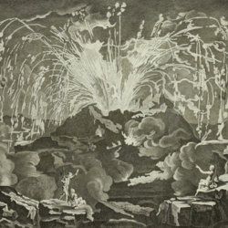
Diderot, D. and J. d'Alembert (eds.)
Encyclopédie ou dictionnaire raisonné des sciences, des arts et des métiers, par une société de gens de lettres mis en ordre par Mons. Diderot. Histoire naturelle. Règne mineral.
Paris, Diderot et d'Alembert, 1768. Folio (43.2 x 27.2 cm). 4 pp., 130 plates (partly folded). Disbound.
Read more
Lacroix, A.
Mineralogie de Madagascar. Tomes I-II-III. [Complete].
Paris, Augustin Challamel, 1922-1923. Three parts in three. 4to (27.1 x 21.3 cm). 1,799 [xvi, 624; vii, 694; viii, 450] pp.; 540 text illustrations [504; 11; 25], 64 plates [27; 29; 8], one tinted double-sized geographical map of Madagascar, Mayotte, and the Comores (in volume I), one very large, multi-folded full colour geological map (in volume III). Uniform contemporary red buckram. Spines with gilt title. Marbled endpapers. Speckled edges.
Read more
Schmidt, R. R.
Die diluviale Vorzeit Deutschlands.
Stuttgart, E. Schweizerbart (Nägele und Dr. Sproesser), 1912. Very large 4to (35.5 x 30.0 cm). xiii, 283 pp.; 47 engraved or heliogravure plates with explanatory text leaves, loose in rear pocket. Original quarter vellum over cloth boards. Gilt title on front board; gilt-lettered morocco label on the spine.
Read more
Titsingh, [I.]
Mémoires et anecdotes sur la dynastie régnante des djogouns, souverains du Japon, avec la description des fêtes et cérémonies observées aux différentes epoques de l'année a la cour de ces princes, et un appendice contenant des détails sur la poésie des Japonais, leur manière de diviser l'année, etc; ouvrage orné de planches gravées et coloriées, tiré des originaux Japonais par M. Titsingh; publié avec les notes et éclaircissemens par M. Abel Rémusat.
Paris, A. Nepveu, 1820. 8vo (19.3 x 12.0 cm). xxviii, 302 pp.; one hand-coloured folded frontispiece, one engraved folded table, five hand-coloured folded plates. Contemporary full tree calf. Spine rich gilt including empire vignettes and a red morocco label with gilt title. Marbled endpapers. Edges speckled.
Read more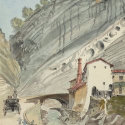
["JAM" (R. de Bouillé, Comte)]
[Original watercolour sketches of French landscapes]
[France], no place, no publisher, ca. 1863-1890. 13 oblong sheets (22.3 x 29.2 cm), all with fine watercolour paintings, either full-sized, or smaller, in a drawn rectangular frame. And one drawing on slightly smaller paper, more sketchy, in pencil.
Read more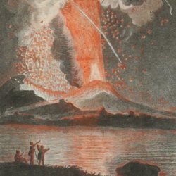
Torcia, M.
Relazione dell'ultima eruzione del Vesuvio. Accaduta nel mese di agosto di questo anno 1779. Rélation de la dernière éruption du Vésuve. Arrivée au mois d'Août de cette année 1779.
Napoli, Raimondi, 1779. 8vo (18.6 x 12.0 cm). Two title pages (Italian and French) with different engraved vignettes, [vi], 135 pp. (separated by a blank page), one folded engraved view of the eruption engraved by Boilly and nicely hand-coloured by Volaire. Contemporary vellum. Spine with gilt-lettered label.
Read more
[Geological map]
Geognostische Karte von Württemberg [AND] Begleitworte zur geognostischen Specialkarte von Württemberg.
Stuttgart, Das Königliches Statistisch-topographisches Bureau, Kohlhammer, Kleeblatt, 1863-1892. With 54 chromolithographed folded geological maps, all mounted on linen, numbered 1-48, 50-55, in two original, uniform burgundy boxes with gilt title on the lid. [AND] the "Begleitworte" 34 parts in one. Large 8vo (25.7 x 19.5 cm). Stuttgart, Königlich Statistischen Landesambt, (1865-1892). ca. 1,000 pp., and five hand-coloured wood-engraved or lithographed maps or geological profiles, and four wood-engraved plates. Contemporary half cloth over marbled boards. Spine with gilt title, ornaments, and the Württemberg coat-of-arms; patterned endpapers, and marbled edges.
Read more
