
Regional Earth Sciences - Geology
69 items found
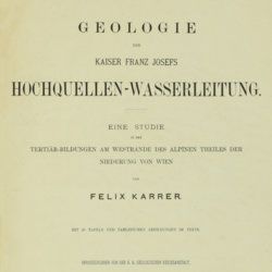
Karrer, F.
Geologie der Kaiser Franz Josefs Hochquellen-Wasserleitung. Eine Studie in den Tertiär-Bildungen am Westrande des alpinen Theiles der Niederung von Wien.
Wien, Hölder, 1877. Large 4to (33.5 x 25.5 cm). xiii, 420 pp.; 96 text engravings, 20 folded profiles, maps and lithographed plates, mostly coloured and several very large (size up to 32 x 100 cm), seven folded charts and tables. Later half cloth with paper label on the spine.
Read more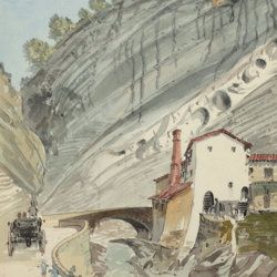
["JAM" (R. de Bouillé, Comte)]
[Original watercolour sketches of French landscapes]
[France], no place, no publisher, ca. 1863-1890. 13 oblong sheets (22.3 x 29.2 cm), all with fine watercolour paintings, either full-sized, or smaller, in a drawn rectangular frame. And one drawing on slightly smaller paper, more sketchy, in pencil.
Read more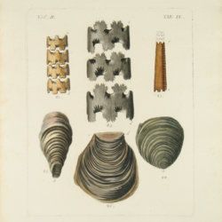
Hochstetter, F. von and A. Petermann.
The geology of New Zealand: in explanation of the geographical and topographical atlas of New Zealand by Dr. F. Von Hochstetter and Dr. A. Petermann, from the Scientific Publications of the Novara Expedition. Translated by C. F. Fischer. Also, lectures by Dr. F. Hochstetter delivered in New Zealand.
Auckland, T. Delattre, 1864. 8vo (21.0 x 13.6 cm). Title page, 113 pp. Original grained red cloth with gilt title on the front board.
Read more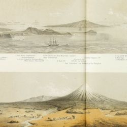
Hochstetter, [C. G.] F. [Ritter] von
Reise der oesterreichischen Fregatte Novara um die Erde in den Jahren 1857, 1858, 1859 unter den Befehlen des Commodore B. von Wüllerstorf-Urbair. Geologischer Theil. Erster Band: Erste Abtheilung, Geologie von Neu-Seeland [AND] Zweite Abtheilung, Paläontologie von Neu-Seeland.
Wien, Karl Gerold's Sohn, 1864-1865. In two volumes. 4to (31.0 x 24.2 cm). Volume 1 (1864): Half-title and title page; tissue-guarded frontispiece; xlvii, 274 pp.; two unnumbered chromolithographed plates (tissue-guarded); six large, folded, full-colour tissue-guarded maps [Tafeln 1-6]; five plates with engraved or tinted views [Tafeln 7-11]; numerous text engravings; volume 2 (1865): half-title and title page, sectional titles; pp. v-vii, 1-318; 26 lithographed plates [numbered I-XXVI], of which several tinted, and each with explanatory text leaves. Original uniform, printed wrappers.
Read more
Hamilton, W.
Voyage à la cote septentrionale du Comté d'Antrim en Irlande, et à l'ile de Raghery, contenant l'histoire naturelle de ses productions volcaniques & plusieurs observations sur les antiquités & moeurs de ce pays... auquel on a ajouté l'essai sur l'oryctographie du Derbyshire par M. Ferber, traduit de l'Allemand.
Paris, Cuchet, 1790. 8vo (19.6 x 12.5 cm). viii, 239 pp.; engraved folding plate showing several geological layers of Derbyshire. Contemporary full mottled calf. Spine rich gilt with floral vignettes, small red morocco label with gilt title. Marbled endpapers, red edges.
Read more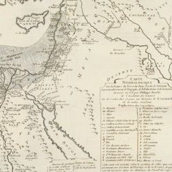
Guettard, J. E.
Histoire de l'Academie Royale des sciences, Année MDCCLI [1751], avec les mémoires de mathématique & de physique, pour la même année. Tirés des registres de cette académie.
Paris, l'Imprimerie Royale, 1755. 4to (25.1 x 18.9 cm). 738 [202, 536] pp.; 23 mostly large, folded plates. Contemporary full tree-calf. Spine with five raised bands, gilt title and gilt vignettes. Marbled endpapers. Red edges.
Read more
Granö, J. G.
Beiträge zur Kenntnis der Eiszeit in der Nordwestlichen Mongolei und einigen ihrer südsibirischen Grenzgebirge. Geomorphologische Studien aus den Jahren 1905, 1906, 1907 und 1909.
Helsingfors, J. Simelii [for the Geographical Society of Finland], 1910. Large 8vo (24.9 x 16.5 cm). iv, 230 pp.; seven large, folded coloured maps, 19 photographic plates. Later quarter calf over pictorial boards.
Read more
[Geological map]
Geognostische Karte von Württemberg [AND] Begleitworte zur geognostischen Specialkarte von Württemberg.
Stuttgart, Das Königliches Statistisch-topographisches Bureau, Kohlhammer, Kleeblatt, 1863-1892. With 54 chromolithographed folded geological maps, all mounted on linen, numbered 1-48, 50-55, in two original, uniform burgundy boxes with gilt title on the lid. [AND] the "Begleitworte" 34 parts in one. Large 8vo (25.7 x 19.5 cm). Stuttgart, Königlich Statistischen Landesambt, (1865-1892). ca. 1,000 pp., and five hand-coloured wood-engraved or lithographed maps or geological profiles, and four wood-engraved plates. Contemporary half cloth over marbled boards. Spine with gilt title, ornaments, and the Württemberg coat-of-arms; patterned endpapers, and marbled edges.
Read more
Fuchs, W.
Die Venetianer Alpen. Ein Beitrag zur Kenntniss der Hochgebirgte, met einen geognostischen Karte und Gebirgteprofilen in achtzehn Tafeln.
Solothurn, Jent & Gassmann, 1844. Oblong folio (29.8 x 35.5 cm), [4], 60 pp.; 18 mostly hand-coloured engraved maps and plates. Text pages bordered with putti and goddesses. 19th century iridescent blue blind cloth.
Read more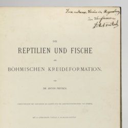
Fritsch, A. [J.]
Die Reptilien und Fische der böhmischen Kreideformation.
Prag, Verlag des Verfassers (Fr. Řivnáč), 1878. Large 4to (33.5 x 25.1 cm). [ii], 44, [ii] pp.; 66 text engravings; ten lithographed plates of which nine tinted, and two larger, folded. Original blind quarter linen over printed boards.
Read more
