
Regional Earth Sciences - Geology
69 items found
Devèze de Chabrol, J. S. and J. B. Bouillet
Essai géologique et minéralogique sur les environs d'Issoire, département du Puy-de-Dôme, et principalement sur la Montagne de Boulade.
Clermont-Ferrand, Thibaud-Landriot, 1827. Folio (41.0 x 26.2 cm). xii, 104 pp.;hand-coloured lithographed geological map and hand-coloured profile, and 30 lithographed plates depicting vertebrates and several tables, including one very large, folded in the text. Contemporary half morocco over marbled boards. Spine with gilt lines and title. Marbled endpapers; speckled edges.
Read more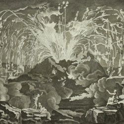
Diderot, D. and J. d'Alembert (eds.)
Encyclopédie ou dictionnaire raisonné des sciences, des arts et des métiers, par une société de gens de lettres mis en ordre par Mons. Diderot. Histoire naturelle. Règne mineral.
Paris, Diderot et d'Alembert, 1768. Folio (43.2 x 27.2 cm). 4 pp., 130 plates (partly folded). Disbound.
Read more
Rothpletz, A.
Ein geologischer Querschnitt durch die Ost-Alpen nebst Anhang über die sog. Glarner Doppelfalte.
Stuttgart, E. Schweizerbart (E. Koch), 1894. 8vo (22.4 x 15.4 cm). iv, 208 pp.; two full colour folded profiles of which one measuring 22.5 x 352.0 cm (!), 115 text illustrations. Contemporary half cloth over marbled boards. Gilt lines and two red morocco labels with gilt title on the spine. Edges speckled.
Read more
Fuchs, W.
Die Venetianer Alpen. Ein Beitrag zur Kenntniss der Hochgebirgte, met einen geognostischen Karte und Gebirgteprofilen in achtzehn Tafeln.
Solothurn, Jent & Gassmann, 1844. Oblong folio (29.8 x 35.5 cm), [4], 60 pp.; 18 mostly hand-coloured engraved maps and plates. Text pages bordered with putti and goddesses. 19th century iridescent blue blind cloth.
Read more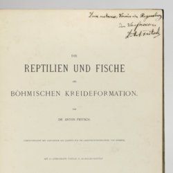
Fritsch, A. [J.]
Die Reptilien und Fische der böhmischen Kreideformation.
Prag, Verlag des Verfassers (Fr. Řivnáč), 1878. Large 4to (33.5 x 25.1 cm). [ii], 44, [ii] pp.; 66 text engravings; ten lithographed plates of which nine tinted, and two larger, folded. Original blind quarter linen over printed boards.
Read more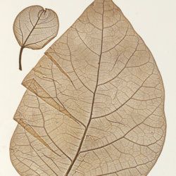
Ettingshausen, C., von
Die Fossile Flora des Tertiär-Beckens von Bilin. I Theil. (Enthaltend die Thallophyten, Kryptogamischen Gefässpflanzen; Monokotyledonen, Coniferen, Julifloren und Oleraceen).
Wien, Kaiserlichen Akademie der Wissenschaften, 1867. 4to (29.6 x 23.1 cm). 95 pp.; 30 tinted lithographed plates. Later boards, printed label mounted on front board.
Read more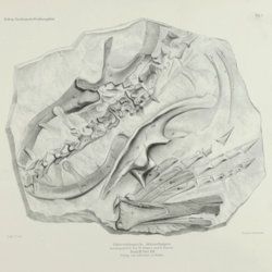
Schmidt, R. R.
Die diluviale Vorzeit Deutschlands.
Stuttgart, E. Schweizerbart (Nägele und Dr. Sproesser), 1912. Very large 4to (35.5 x 30.0 cm). xiii, 283 pp.; 47 engraved or heliogravure plates with explanatory text leaves, loose in rear pocket. Original quarter vellum over cloth boards. Gilt title on front board; gilt-lettered morocco label on the spine.
Read more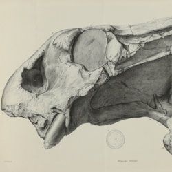
Owen, R.
Descriptive and illustrated catalogue of the fossil Reptilia of South Africa in the collection of the British Museum.
London, The Trustees of the British Museum, 1876. Folio (32.5 x 25.2 cm). xii, 88 pp.; 70 fine lithographed plates, several larger, and folded. Original green pebbled and blind-tooled cloth. Gilt title on the spine.
Read more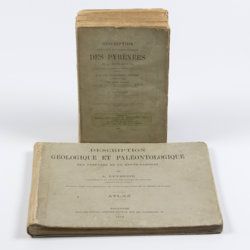
Leymerie, A. [F. G. A.]
Description géologique et paléontologique des Pyrenées de la Haute-Garonne accompagnée d'une carte topographique et géologique à l'echelle 1:200.000 et d'un Atlas...
Toulouse, Privat, 1878, 1881. In two volumes. Text (1881) 8vo (24.0 x 16.0 cm). Atlas (1878) oblong 4to (23.5 x 31.5 cm). 1,027 pp.; 51 lithographed plates of which 11 tinted or coloured (and of which 30 are on fossils), including a large folded transection of the Pyrenees, Haute Garonne, and the large coloured geological map (with 20 colours) mounted on linen. Original printed wrappers (text) and boards (atlas).
Read more
Passy, A. [F.]
Description géologique du département de la Seine-Inférieure. [Text and Atlas].
Rouen, Nicétas Periaux, 1832. Two parts [text and atlas] in one. 4to (26.7 x 21.3 cm). 402 pp. [xvi, 371; 15]; 20 engraved plates (several double-sized), of which 15 in original hand-colouring. Contemporary quarter morocco over marbled boards; spine with gilt title. Marbled endpapers.
Read more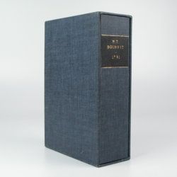
Bourrit, M. T.
Description des Alpes, Pennines et Rhetiennes; dédiée a.s.m. très-chrétienne Louis XVI, roi de France et de Navarre. Tome premier - second. [Complete].
Genève, J. P. Bonnant, 1781. In two volumes. 8vo (21.5 x 13.8 cm). xix, 247 pp.; [ii], 285 pp.; eight engraved plates, mainly of glaciers, and one folded engraved map of the Alps, several wood engraved vignettes in the text. Original uniform blind publishers' wrappers. Spines renewed with later printed labels. Contained in a later blue cloth slipcase (23.2 x 15.8 x 6.9 cm) with black morocco label with gilt title.
Read more
Tollmann, A.
Das Neogen am Südwestrand des Leithagebirges zwischen Eisenstadt und Hornstein. Dissertation zur Erlangung des Doktorgrades an der Philosophischen Fakultät der Universität Wien.
Wien, [not published], 1953. Small folio (29.8 x 21.0 cm). 226 pp.; 28 text figures (tipped in), three large folded maps (one hand-coloured), five folded tables and graphs. Black half cloth. Hand-written label on the spine.
Read more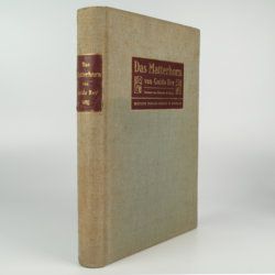
Rey, G.
Das Matterhorn. Vorwort von E. de Amicis with geologische Erläuterungen by V. Novarese.
Stuttgart and Leipzig, Deutsche Verlags-Anstalt, 1905. 4to (29.2 x 21.0 cm). xi, 258 pp.; 35 plates of which 14 are nicely tinted photographic plates after water-colours, mounted on black paper, all by Edoardo Rubino and 11 photographs (most by Vittorio Sella and a few by G. Rey) and ten photographic plates from drawings also by Edoardo Rubino. Furthermore there are 13 images of drawings in the text also by Edoardo Rubino [complete]. Original cloth with bevelled edges, gilt mounted title piece on front board and gilt-lettered spine label. Mottled olive endpapers. Top edge gilt.
Read more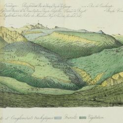
Lecoq, H. and J. B. Bouillet
Coup d'oeil sur la structure géologique et minéralogique du groupe des Monts Dores, accompagné de la description et des échantillons des substances minérales qui le composent.
Paris, Levrault and Clermont-Ferrand, Bouillet, Thibaud-Landriot, 1830. 8vo (20.0 x 13.1 cm). 48 pp.; five handcoloured lithographed plates (two much larger, folded) of geological views and profiles of the volcanological region of Puy-de-Dôme. Later red quarter calf over marbled boards. Gilt title on the spine. Marbled endpapers. Speckled edges.
Read more
Mille, M. et al.
Contrôle des Chemins de Fer. Ligne de Paris à Brest. Réseau d'Orléans. Profil géologique suivant le tracé du chemin de fer dressé sur les indications de M.M. Triger et Delesse. Notice par M. Mille ingénieur en Chef des Ponts et Chaussées 1867.
Paris, Jules Bonaventure, 1866-1867. In four parts. 4to. Title-page, 9 pp. (text volume); one folded, chromolithographed profile (31.0 x 99.8 cm), titled: Coupe des huillères de Chalonnes d'après les travaux des ingénieurs de la mine; one very long folded profile (31 x 957 cm, including title and legend) titled: Section de Paris à Angers par Vendôme et Tours; a second very long folded chromolithographed profile (31 x 1147 [!] cm), title: Section de Angers à Brest par Nantes et Chateaulin. All four contained in a blind stamped cloth portfolio with gilt title on the spine and top board.
Read more
Granö, J. G.
Beiträge zur Kenntnis der Eiszeit in der Nordwestlichen Mongolei und einigen ihrer südsibirischen Grenzgebirge. Geomorphologische Studien aus den Jahren 1905, 1906, 1907 und 1909.
Helsingfors, J. Simelii [for the Geographical Society of Finland], 1910. Large 8vo (24.9 x 16.5 cm). iv, 230 pp.; seven large, folded coloured maps, 19 photographic plates. Later quarter calf over pictorial boards.
Read more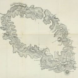

Lecoq, H.
[Auvergne] Itinéraire de Clermont au Puy de Dome, ou description de cette montagne et de la Vallée de Royat et Fontanat; seconde edition. [AND] Two other papers on the geology of Auvergne, by A. C. P. F. Von Lasaulx, and by J. B. Bouillet, bound in.
Paris, J. B. Baillière, 1836. 8vo (21.2 x 13.3 cm). vi, 102 pp. Early 20th century half morocco over marbled boards. Spine with five raised bands and gilt title. Marbled endpapers.
Read more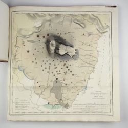
[Various authors]
Annales des Mines. Series III-VI. Atlases.
Paris, Ecole de Mines, 1832-1866. Two series in four. Oblong folio (40.5 x 22.0 cm) with 758 (of 759? see below) engraved and lithographed plates and maps, of which 29 are hand-coloured geological maps or profiles. Contemporary uniform red cloth. Gilt titles on the spines and front boards. Marbled endpapers.
Read more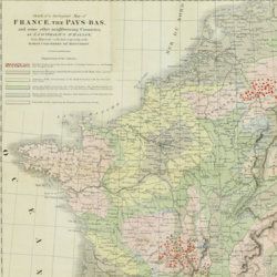
Beche, H. de la
A selection of the Geological Memoirs, contained in the Annales des Mines, together with a synoptical table of equivalent formations and Brongniart's table of the classification of mixed rocks. Translated with notes by H. T. de la Beche, Esq.
London, William Phillips, 1824. 8vo (21.1 x 13.3 cm). xxii, 335 pp.; one hand-coloured folded geological map of France and the Netherlands including a great part of Germany, the Alps and northern Italy, by J. d'Omalius d'Halloy (numbered plate 11 [not II]) and two further hand-coloured geological maps or profiles (numbered I-II), eight folded lithographed plates (numbered III-X), including a very fine view of the coalmine at Treuil near St. Etienne, one folding table. Contemporary half calf over marbled boards. Spine with gilt lines and title. Edges speckled red.
Read more
