
Regional Earth Sciences - Geology
69 items found
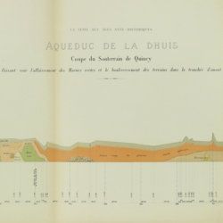
Belgrand, [M. F.] E.
Histoire générale de Paris. La Seine. I. Le bassin Parisien aux âges antéhistoriques.
Paris, Imprimerie Impériale, 1869. In three parts (Texte, Atlas de Paléontologie, and Planches de Géologie et de Conchyliologie). Large 4to and folio (33.8 x 23.9 cm). Texte: cvi, 289 pp., four double-sized coloured maps, 36 engraved text figures, five tissue-guarded plates (four profiles and one with stone age axes); Atlas: 82 [46, a-d] pp.; seven text engravings, 86 plates [1-79, 29bis, 48bis, 53bis, 59bis, 59ter, 62bis, 62ter, 78bis) being tissue guarded heliogravures of mammalian bones, including human skulls, etc., and stone age tools. Géologie and Conchyliologie, 32 pp. Three lithographed plates of shells, three very large folded, coloured geological profiles (numbered 5-7, being a suite to the maps in the text part). All in original green, printed boards or wrappers. Not in Nissen, ZBI.
Read more
Ettingshausen, C., von
Die Fossile Flora des Tertiär-Beckens von Bilin. I Theil. (Enthaltend die Thallophyten, Kryptogamischen Gefässpflanzen; Monokotyledonen, Coniferen, Julifloren und Oleraceen).
Wien, Kaiserlichen Akademie der Wissenschaften, 1867. 4to (29.6 x 23.1 cm). 95 pp.; 30 tinted lithographed plates. Later boards, printed label mounted on front board.
Read more
Lecoq, H.
Les époques géologiques de l'Auvergne. Avec 170 planches ou figures, dont plusieurs coloriées et des autographes de Dolomieu, d'Hauy & de De Saussure et un dessin fac simile de Madame Necker de Saussure. I-V. [Complete].
Paris, Baillière et fils, 1867. Five volumes in five. Large 8vo (23.7 x 15.2 cm). 2,758 pp.; 180 engraved and lithographed (tinted, or chromolithographed) plates [1-141, 143-169, 41(bis), 57(bis), 89bis, 107(bis), 149bis, 152bis, 163bis, 163ter, 165bis, 165ter, 165quater, 165quinter], on 107 sheets (several double-sized). Uniform burgundy half morocco over marbled boards. Spines with five raised bands, gilt title. Marbled endpapers. Speckled edges.
Read more
Mille, M. et al.
Contrôle des Chemins de Fer. Ligne de Paris à Brest. Réseau d'Orléans. Profil géologique suivant le tracé du chemin de fer dressé sur les indications de M.M. Triger et Delesse. Notice par M. Mille ingénieur en Chef des Ponts et Chaussées 1867.
Paris, Jules Bonaventure, 1866-1867. In four parts. 4to. Title-page, 9 pp. (text volume); one folded, chromolithographed profile (31.0 x 99.8 cm), titled: Coupe des huillères de Chalonnes d'après les travaux des ingénieurs de la mine; one very long folded profile (31 x 957 cm, including title and legend) titled: Section de Paris à Angers par Vendôme et Tours; a second very long folded chromolithographed profile (31 x 1147 [!] cm), title: Section de Angers à Brest par Nantes et Chateaulin. All four contained in a blind stamped cloth portfolio with gilt title on the spine and top board.
Read more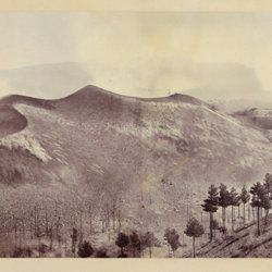
Berthier, P. [M.]
Photographic panorama of Mount Etna.
Paris, Paul Berthier, 1865. Very large board (93.0 x 45.0 cm), with original mounted albumen silver prints (panorama, in two parts of 25.0 x 36.2 cm and 25.0 x 35.0 cm, for a continuous image with a total width of 71.2 cm). Paul Berthier printed studio label pasted on verso.
Read more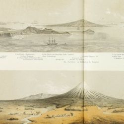
Hochstetter, [C. G.] F. [Ritter] von
Reise der oesterreichischen Fregatte Novara um die Erde in den Jahren 1857, 1858, 1859 unter den Befehlen des Commodore B. von Wüllerstorf-Urbair. Geologischer Theil. Erster Band: Erste Abtheilung, Geologie von Neu-Seeland [AND] Zweite Abtheilung, Paläontologie von Neu-Seeland.
Wien, Karl Gerold's Sohn, 1864-1865. In two volumes. 4to (31.0 x 24.2 cm). Volume 1 (1864): Half-title and title page; tissue-guarded frontispiece; xlvii, 274 pp.; two unnumbered chromolithographed plates (tissue-guarded); six large, folded, full-colour tissue-guarded maps [Tafeln 1-6]; five plates with engraved or tinted views [Tafeln 7-11]; numerous text engravings; volume 2 (1865): half-title and title page, sectional titles; pp. v-vii, 1-318; 26 lithographed plates [numbered I-XXVI], of which several tinted, and each with explanatory text leaves. Original uniform, printed wrappers.
Read more
Hochstetter, F. von and A. Petermann.
The geology of New Zealand: in explanation of the geographical and topographical atlas of New Zealand by Dr. F. Von Hochstetter and Dr. A. Petermann, from the Scientific Publications of the Novara Expedition. Translated by C. F. Fischer. Also, lectures by Dr. F. Hochstetter delivered in New Zealand.
Auckland, T. Delattre, 1864. 8vo (21.0 x 13.6 cm). Title page, 113 pp. Original grained red cloth with gilt title on the front board.
Read more
[Geological map]
Geognostische Karte von Württemberg [AND] Begleitworte zur geognostischen Specialkarte von Württemberg.
Stuttgart, Das Königliches Statistisch-topographisches Bureau, Kohlhammer, Kleeblatt, 1863-1892. With 54 chromolithographed folded geological maps, all mounted on linen, numbered 1-48, 50-55, in two original, uniform burgundy boxes with gilt title on the lid. [AND] the "Begleitworte" 34 parts in one. Large 8vo (25.7 x 19.5 cm). Stuttgart, Königlich Statistischen Landesambt, (1865-1892). ca. 1,000 pp., and five hand-coloured wood-engraved or lithographed maps or geological profiles, and four wood-engraved plates. Contemporary half cloth over marbled boards. Spine with gilt title, ornaments, and the Württemberg coat-of-arms; patterned endpapers, and marbled edges.
Read more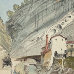
["JAM" (R. de Bouillé, Comte)]
[Original watercolour sketches of French landscapes]
[France], no place, no publisher, ca. 1863-1890. 13 oblong sheets (22.3 x 29.2 cm), all with fine watercolour paintings, either full-sized, or smaller, in a drawn rectangular frame. And one drawing on slightly smaller paper, more sketchy, in pencil.
Read more
Meyer, C. E. H. von
Ueber den Nager von Waltsch in Böhmen [AND] Physichthys Höninghausi aus dem Uebergangkalke der Eifel [AND] Schildkröte und Vogel aus dem Fischschiefer von Glarus [AND] Helochelys Danubia, aus dem Grünsande von Kelheim in Bayern [AND] Trachyteuthis ensiformisaus dem lithographischen Schiefer in Bayern.
Cassel [Kassel], Palaeontographica, 1855. Six papers in one. 4to (31.0 x 23.2 cm). 35 [5; 4; 12; 10; 4] pp.; six engraved plates [1; 1; 2 (one shared); 2 (one shared); 1], the two turtle and one cephalopod plate double-sized. Contemporary wrappers with the title added in script.
Read more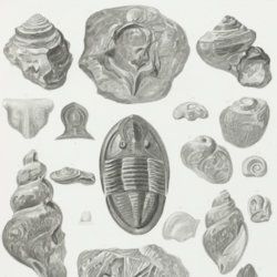
Owen, D. D.
Report of a geological survey of Wisconsin, Iowa and Minnesota; and incidentally of a portion of Nebraska territory. Made under instructions from the United States Treasury Department [AND] Illustrations to the geology report of Wisconsin, Iowa, and Minnesota.
Philadelphia, PA, Lippincott, Grambo & Co., 1852. Two parts in two. 4to (31.1 x 23.0 cm). Engraved frontispiece and title page, 639 pp. (first xxxviii in Roman numbers), numerous fine steel-engravings (text volume); title page, 27 (I-XV, IA-D, IIA-B, IIIA, VA-B, VIIIA, XIIA-B) fine lithographed plates with explanatory text leaves, and 21 mostly folding (all but two) and (partly) hand-coloured (all but two) geological maps, views, and profiles (atlas volume). Original near uniform blind-tooled cloth. Text volume spine with gilt title, plate volume with gilt title on the front board.
Read more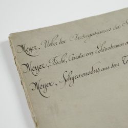
Meyer, H. von
Ueber den Archegosaurus der Steinkohlenformation [AND] Fische, Echinodermen und andere Versteinerungen aus dem Muschelkalk Oberschlesiens [AND] Sphyraenodus aus dem Tertiärsande von Flonheim.
Cassel, Palaeontographica, 1849. 4to (29.2 x 23.0 cm). 76 [5; 68; 3] pp.; four engraved plates. Contemporary wrappers with the titles added in a neat old hand.
Read more
