
Regional Earth Sciences - Geology
69 items found

Forbes, J. D.
Reisen in den Savoyer Alpen und in anderen Theilen der Penninen-Kette, nebst Beobachtungen über die Gletscher.
Stuttgart, Schweizerbart, 1845. 8vo (21.0 x 13.3 cm). xii, 386 pp.; seven lithographed plates (of which one hand-coloured) and two folded lithographed maps depicting the Chamonix Alps. Early 20th-century cloth with mounted title and backstrip from original printed boards and spine.
Read more
Fuchs, W.
Die Venetianer Alpen. Ein Beitrag zur Kenntniss der Hochgebirgte, met einen geognostischen Karte und Gebirgteprofilen in achtzehn Tafeln.
Solothurn, Jent & Gassmann, 1844. Oblong folio (29.8 x 35.5 cm), [4], 60 pp.; 18 mostly hand-coloured engraved maps and plates. Text pages bordered with putti and goddesses. 19th century iridescent blue blind cloth.
Read more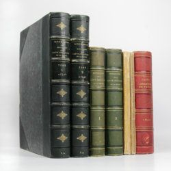
Dufrenoy, [O. P. A.] and [J. B. A. L. L.] Élie de Beaumont
Explication de la carte géologique de la France. Volumes I-IV (text and atlas), and two maps. [Complete].
Paris, Imprimerie Royale, Imprimerie Nationale, 1841-1879. Four volumes in seven, and a large map in six folded sheets, each ca. 70 x 205 cm (including borders) with linen covers. Large 4to (four text volumes; ca. 27.5 x 21.0 cm); folio (two atlas volumes, 26.8 x 35.7 cm). Tome premier: Paris, Imprimerie Royale, 1841. Large 4to. xxii, 825 pp., 71 text engravings (mainly profiles); Tome deuxième: Paris, Imprimerie Nationale, 1848. Large 4to. xii, 813 pp., 105 text engravings (mainly views and profiles), one large, folded chromolithographed geological map (finished by hand) of France (printed surface: 57 x 54 cm, and consisting of 15 smaller sections, mounted on linen and folded) bound in the rear; Tome troisième. Première partie (by Dufrénoy): Paris, Imprimerie Nationale, 1873. Large 4to. viii, 231 pp., 18 text engravings (mainly profiles). Printed wrappers. Tome quatrième. Seconde partie. Végétaux fossiles du terrain houiller (by Zeiller): Paris, Imprimerie Nationale, 1879. Large 4to. 185 pp. Printed wrappers; Tome quatrième. Atlas (in two volumes). Première partie. Fossiles principaux des terrains (by É. Bayle). Seconde partie. Végétaux fossiles du terrain houiller (by Zeiller): Paris, Imprimerie Nationale, 1878. Folio. Title page, half title to first part. 86 lithographed plates with explanatory text leaves, numbered I-LXXXVI; 90 lithographed plates with explanatory text leaves, numbered LXXXVII-CLXXVI (the last 16 on plants), for a total of 176 plates. Volumes I, II, and IV plate volumes in near uniform contemporary dark-green pebbled morocco over marbled boards. Spines with five gilt-stippled bands, and gilt title. Marbled endpapers. The text volumes with top edge gilt, atlases with marbled top edges. Text volumes III and IV in original printed wrappers. The large chromolithographed map in six sheets (approximately 218 x 223 cm) is contained in a contemporary, book-like crimson box with gilt-lettered spine, with raised bands and patterned paper sides.
Read more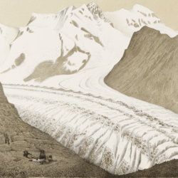
Agassiz, L.
Untersuchungen über die Gletscher. [Complete text and atlas].
Solothurn, Jent & Gassmann, 1840-1841; Neuchatel, H. Nicolet, 1840. Text: 8vo (21.5 x 14.2 cm). xii, 326, [i] pp. 19th-century pebbled half cloth over marbled boards. Spine with gilt ornamental bands and title. Greenish endpapers. Subtly marbled edges. Atlas: Oblong folio (29.7 x 44.0 cm). 18 lithographed plates of which 14 with printed overlays (as intended). Contemporary green quarter calf over green boards. Spine with gilt bands. Original pictorial title mounted on front board.
Read more
Catullo, T. A.
Trattato sopra la costituzione geognostico-fisica dei terreni alluviani o postdiluviani delle provincie Venete.
Padova, Cartallier e Sicca, 1838. 8vo (21.2 x 13.3 cm). Title page with engraved vignette, [iv], 512 pp.; several tables in the text. Mid-19th-century pebbled cloth. Gilt title on the spine.
Read more
Robert, E. [Gaimard]
Voyage en Islande et au Groënland executé pendant les années 1835 et 1836 sur la corvette La Recherche commandée par M. Tréhouart Lieutenant de Vaisseau dans le but de découvrir les traces de La Lilloise. Publié par ordre du Roi sous la direction de M. Paul Gaimard président de la Commission Scientifique d'Islande et de Groënland. Minéralogie et géologie.
Paris, Arthus Bertrand, 1838-1840. Two parts in one. Large 8vo (22.7 x 15.1 cm). Title page (to the text, dated 1840), xi, 469 pp.; second title page (to the atlas, dated 1838), [ii] pp., 36 lithographed plates. Contemporary quarter morocco over marbled boards. Spine rich gilt. Marbled endpapers. Speckled edges.
Read more
Lecoq, H.
[Auvergne] Itinéraire de Clermont au Puy de Dome, ou description de cette montagne et de la Vallée de Royat et Fontanat; seconde edition. [AND] Two other papers on the geology of Auvergne, by A. C. P. F. Von Lasaulx, and by J. B. Bouillet, bound in.
Paris, J. B. Baillière, 1836. 8vo (21.2 x 13.3 cm). vi, 102 pp. Early 20th century half morocco over marbled boards. Spine with five raised bands and gilt title. Marbled endpapers.
Read more
Unger, F.
Ueber den Einfluss des Bodens auf die Vertheilung der Gewächse nachgewissen in der Vegetation des nordöstlichen Tirols.
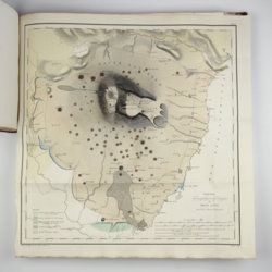
Wien, Rohrmann und Schweigerd, 1836. 8vo (21.4 x 13.5 cm). xxiv, 367 pp.; one hand-coloured engraved plate of Kitzbühl, one large, folded, hand-coloured geological-geographical map, one large, folded hand-coloured sheet with geological profile, five folded charts with meteorological observations (four) and botanical observations (one), many tables in the text. Contemporary quarter calf over marbled boards. Spine with gilt lines, vignettes, and title. Marbled endpapers; speckled edges.
Read more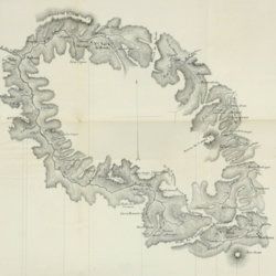
[Various authors]
Annales des Mines. Series III-VI. Atlases.
Paris, Ecole de Mines, 1832-1866. Two series in four. Oblong folio (40.5 x 22.0 cm) with 758 (of 759? see below) engraved and lithographed plates and maps, of which 29 are hand-coloured geological maps or profiles. Contemporary uniform red cloth. Gilt titles on the spines and front boards. Marbled endpapers.
Read more
Passy, A. [F.]
Description géologique du département de la Seine-Inférieure. [Text and Atlas].
Rouen, Nicétas Periaux, 1832. Two parts [text and atlas] in one. 4to (26.7 x 21.3 cm). 402 pp. [xvi, 371; 15]; 20 engraved plates (several double-sized), of which 15 in original hand-colouring. Contemporary quarter morocco over marbled boards; spine with gilt title. Marbled endpapers.
Read more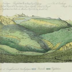
Lecoq, H. and J. B. Bouillet
Coup d'oeil sur la structure géologique et minéralogique du groupe des Monts Dores, accompagné de la description et des échantillons des substances minérales qui le composent.
Paris, Levrault and Clermont-Ferrand, Bouillet, Thibaud-Landriot, 1830. 8vo (20.0 x 13.1 cm). 48 pp.; five handcoloured lithographed plates (two much larger, folded) of geological views and profiles of the volcanological region of Puy-de-Dôme. Later red quarter calf over marbled boards. Gilt title on the spine. Marbled endpapers. Speckled edges.
Read more
