
Regional Earth Sciences - Geology
69 items found

Granö, J. G.
Beiträge zur Kenntnis der Eiszeit in der Nordwestlichen Mongolei und einigen ihrer südsibirischen Grenzgebirge. Geomorphologische Studien aus den Jahren 1905, 1906, 1907 und 1909.
Helsingfors, J. Simelii [for the Geographical Society of Finland], 1910. Large 8vo (24.9 x 16.5 cm). iv, 230 pp.; seven large, folded coloured maps, 19 photographic plates. Later quarter calf over pictorial boards.
Read more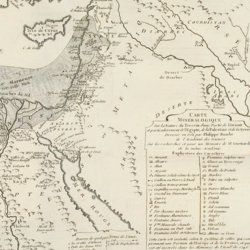
Guettard, J. E.
Histoire de l'Academie Royale des sciences, Année MDCCLI [1751], avec les mémoires de mathématique & de physique, pour la même année. Tirés des registres de cette académie.
Paris, l'Imprimerie Royale, 1755. 4to (25.1 x 18.9 cm). 738 [202, 536] pp.; 23 mostly large, folded plates. Contemporary full tree-calf. Spine with five raised bands, gilt title and gilt vignettes. Marbled endpapers. Red edges.
Read more
Hamilton, W.
Voyage à la cote septentrionale du Comté d'Antrim en Irlande, et à l'ile de Raghery, contenant l'histoire naturelle de ses productions volcaniques & plusieurs observations sur les antiquités & moeurs de ce pays... auquel on a ajouté l'essai sur l'oryctographie du Derbyshire par M. Ferber, traduit de l'Allemand.
Paris, Cuchet, 1790. 8vo (19.6 x 12.5 cm). viii, 239 pp.; engraved folding plate showing several geological layers of Derbyshire. Contemporary full mottled calf. Spine rich gilt with floral vignettes, small red morocco label with gilt title. Marbled endpapers, red edges.
Read more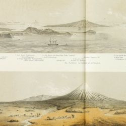
Hochstetter, [C. G.] F. [Ritter] von
Reise der oesterreichischen Fregatte Novara um die Erde in den Jahren 1857, 1858, 1859 unter den Befehlen des Commodore B. von Wüllerstorf-Urbair. Geologischer Theil. Erster Band: Erste Abtheilung, Geologie von Neu-Seeland [AND] Zweite Abtheilung, Paläontologie von Neu-Seeland.
Wien, Karl Gerold's Sohn, 1864-1865. In two volumes. 4to (31.0 x 24.2 cm). Volume 1 (1864): Half-title and title page; tissue-guarded frontispiece; xlvii, 274 pp.; two unnumbered chromolithographed plates (tissue-guarded); six large, folded, full-colour tissue-guarded maps [Tafeln 1-6]; five plates with engraved or tinted views [Tafeln 7-11]; numerous text engravings; volume 2 (1865): half-title and title page, sectional titles; pp. v-vii, 1-318; 26 lithographed plates [numbered I-XXVI], of which several tinted, and each with explanatory text leaves. Original uniform, printed wrappers.
Read more
Hochstetter, F. von and A. Petermann.
The geology of New Zealand: in explanation of the geographical and topographical atlas of New Zealand by Dr. F. Von Hochstetter and Dr. A. Petermann, from the Scientific Publications of the Novara Expedition. Translated by C. F. Fischer. Also, lectures by Dr. F. Hochstetter delivered in New Zealand.
Auckland, T. Delattre, 1864. 8vo (21.0 x 13.6 cm). Title page, 113 pp. Original grained red cloth with gilt title on the front board.
Read more
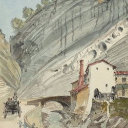
["JAM" (R. de Bouillé, Comte)]
[Original watercolour sketches of French landscapes]
[France], no place, no publisher, ca. 1863-1890. 13 oblong sheets (22.3 x 29.2 cm), all with fine watercolour paintings, either full-sized, or smaller, in a drawn rectangular frame. And one drawing on slightly smaller paper, more sketchy, in pencil.
Read more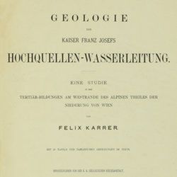
Karrer, F.
Geologie der Kaiser Franz Josefs Hochquellen-Wasserleitung. Eine Studie in den Tertiär-Bildungen am Westrande des alpinen Theiles der Niederung von Wien.
Wien, Hölder, 1877. Large 4to (33.5 x 25.5 cm). xiii, 420 pp.; 96 text engravings, 20 folded profiles, maps and lithographed plates, mostly coloured and several very large (size up to 32 x 100 cm), seven folded charts and tables. Later half cloth with paper label on the spine.
Read more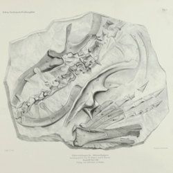
Lacroix, A.
Mineralogie de Madagascar. Tomes I-II-III. [Complete].
Paris, Augustin Challamel, 1922-1923. Three parts in three. 4to (27.1 x 21.3 cm). 1,799 [xvi, 624; vii, 694; viii, 450] pp.; 540 text illustrations [504; 11; 25], 64 plates [27; 29; 8], one tinted double-sized geographical map of Madagascar, Mayotte, and the Comores (in volume I), one very large, multi-folded full colour geological map (in volume III). Uniform contemporary red buckram. Spines with gilt title. Marbled endpapers. Speckled edges.
Read more
Lecoq, H.
[Auvergne] Itinéraire de Clermont au Puy de Dome, ou description de cette montagne et de la Vallée de Royat et Fontanat; seconde edition. [AND] Two other papers on the geology of Auvergne, by A. C. P. F. Von Lasaulx, and by J. B. Bouillet, bound in.
Paris, J. B. Baillière, 1836. 8vo (21.2 x 13.3 cm). vi, 102 pp. Early 20th century half morocco over marbled boards. Spine with five raised bands and gilt title. Marbled endpapers.
Read more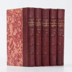
Lecoq, H.
Les époques géologiques de l'Auvergne. Avec 170 planches ou figures, dont plusieurs coloriées et des autographes de Dolomieu, d'Hauy & de De Saussure et un dessin fac simile de Madame Necker de Saussure. I-V. [Complete].
Paris, Baillière et fils, 1867. Five volumes in five. Large 8vo (23.7 x 15.2 cm). 2,758 pp.; 180 engraved and lithographed (tinted, or chromolithographed) plates [1-141, 143-169, 41(bis), 57(bis), 89bis, 107(bis), 149bis, 152bis, 163bis, 163ter, 165bis, 165ter, 165quater, 165quinter], on 107 sheets (several double-sized). Uniform burgundy half morocco over marbled boards. Spines with five raised bands, gilt title. Marbled endpapers. Speckled edges.
Read more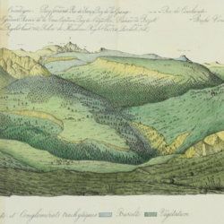
Lecoq, H. and J. B. Bouillet
Coup d'oeil sur la structure géologique et minéralogique du groupe des Monts Dores, accompagné de la description et des échantillons des substances minérales qui le composent.
Paris, Levrault and Clermont-Ferrand, Bouillet, Thibaud-Landriot, 1830. 8vo (20.0 x 13.1 cm). 48 pp.; five handcoloured lithographed plates (two much larger, folded) of geological views and profiles of the volcanological region of Puy-de-Dôme. Later red quarter calf over marbled boards. Gilt title on the spine. Marbled endpapers. Speckled edges.
Read more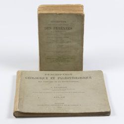
Leymerie, A. [F. G. A.]
Description géologique et paléontologique des Pyrenées de la Haute-Garonne accompagnée d'une carte topographique et géologique à l'echelle 1:200.000 et d'un Atlas...
Toulouse, Privat, 1878, 1881. In two volumes. Text (1881) 8vo (24.0 x 16.0 cm). Atlas (1878) oblong 4to (23.5 x 31.5 cm). 1,027 pp.; 51 lithographed plates of which 11 tinted or coloured (and of which 30 are on fossils), including a large folded transection of the Pyrenees, Haute Garonne, and the large coloured geological map (with 20 colours) mounted on linen. Original printed wrappers (text) and boards (atlas).
Read more
Lippi, C.
Fu il fuoco, o l'acqua che sotterro Pompei ed Ercolano? Scoperta geologico-istorica, fatta dall'autore il di 14 e 26 Ottobre 1810, e da lui scritta nelle lingue latina, inglese, francese, italiana, tedesca, e spagnuola in due lettere. Seguite dalle scritture pro et contra, presentate all' Accademia di scienze di Napoli, per di lei ordine; e dalle decisioni di questa Società, relative al' argomento. Prima edizione Italiana.
Napoli, Domenico Sangiacomo, 1816. 8vo (18.9 x 11.4 cm). [iv], 384 pp.; one folded plate. Contemporary half calf over marbled boards. Rich gilt spine. Edges yellow.
Read more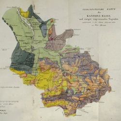
Merian, P.
Uebersicht der Beschaffenheit der Gebirgsbildungen in den Umgebungen von Basel, mit besondrer Hinsicht auf das Juragebirge im Allgemeinen.
Basel, Schweighauser, 1821. 8vo (20.2 x 12.1 cm). xii, 156 pp; one large, folded hand-coloured map and one hand-coloured plate. Original printed wrappers.
Read more
Meyer, C. E. H. von
Ueber den Nager von Waltsch in Böhmen [AND] Physichthys Höninghausi aus dem Uebergangkalke der Eifel [AND] Schildkröte und Vogel aus dem Fischschiefer von Glarus [AND] Helochelys Danubia, aus dem Grünsande von Kelheim in Bayern [AND] Trachyteuthis ensiformisaus dem lithographischen Schiefer in Bayern.
Cassel [Kassel], Palaeontographica, 1855. Six papers in one. 4to (31.0 x 23.2 cm). 35 [5; 4; 12; 10; 4] pp.; six engraved plates [1; 1; 2 (one shared); 2 (one shared); 1], the two turtle and one cephalopod plate double-sized. Contemporary wrappers with the title added in script.
Read more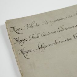
Meyer, H. von
Ueber den Archegosaurus der Steinkohlenformation [AND] Fische, Echinodermen und andere Versteinerungen aus dem Muschelkalk Oberschlesiens [AND] Sphyraenodus aus dem Tertiärsande von Flonheim.
Cassel, Palaeontographica, 1849. 4to (29.2 x 23.0 cm). 76 [5; 68; 3] pp.; four engraved plates. Contemporary wrappers with the titles added in a neat old hand.
Read more
Mille, M. et al.
Contrôle des Chemins de Fer. Ligne de Paris à Brest. Réseau d'Orléans. Profil géologique suivant le tracé du chemin de fer dressé sur les indications de M.M. Triger et Delesse. Notice par M. Mille ingénieur en Chef des Ponts et Chaussées 1867.
Paris, Jules Bonaventure, 1866-1867. In four parts. 4to. Title-page, 9 pp. (text volume); one folded, chromolithographed profile (31.0 x 99.8 cm), titled: Coupe des huillères de Chalonnes d'après les travaux des ingénieurs de la mine; one very long folded profile (31 x 957 cm, including title and legend) titled: Section de Paris à Angers par Vendôme et Tours; a second very long folded chromolithographed profile (31 x 1147 [!] cm), title: Section de Angers à Brest par Nantes et Chateaulin. All four contained in a blind stamped cloth portfolio with gilt title on the spine and top board.
Read more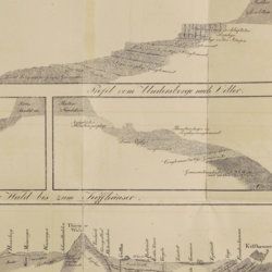
Oeynhausen, C. von and H. von Dechen and H. von La Roche
Geognostische Umrisse der Rheinländer zwischen Basel und Mainz mit besonderer Rücksicht auf das Vorkommen des Steinsalzes, nach Beobachtungen entworfen auf einer Reise im Jahre 1823 gesammelt.
Essen, G. Bädeker, 1825. Two volumes in one. 8vo (19.8 x 12.0 cm). 782 pp.; one folding lithographed plate with several geological profiles. Contemporary half cloth over marbled boards. Paper label with the title in an old hand on the spine. Original endpapers.
Read more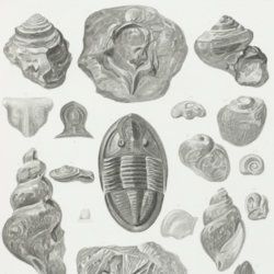
Owen, D. D.
Report of a geological survey of Wisconsin, Iowa and Minnesota; and incidentally of a portion of Nebraska territory. Made under instructions from the United States Treasury Department [AND] Illustrations to the geology report of Wisconsin, Iowa, and Minnesota.
Philadelphia, PA, Lippincott, Grambo & Co., 1852. Two parts in two. 4to (31.1 x 23.0 cm). Engraved frontispiece and title page, 639 pp. (first xxxviii in Roman numbers), numerous fine steel-engravings (text volume); title page, 27 (I-XV, IA-D, IIA-B, IIIA, VA-B, VIIIA, XIIA-B) fine lithographed plates with explanatory text leaves, and 21 mostly folding (all but two) and (partly) hand-coloured (all but two) geological maps, views, and profiles (atlas volume). Original near uniform blind-tooled cloth. Text volume spine with gilt title, plate volume with gilt title on the front board.
Read more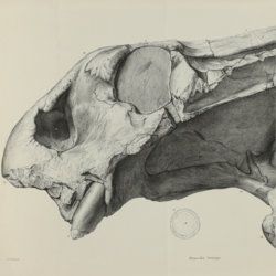
Owen, R.
Descriptive and illustrated catalogue of the fossil Reptilia of South Africa in the collection of the British Museum.
London, The Trustees of the British Museum, 1876. Folio (32.5 x 25.2 cm). xii, 88 pp.; 70 fine lithographed plates, several larger, and folded. Original green pebbled and blind-tooled cloth. Gilt title on the spine.
Read more
Palassou, P. B.
Mémoires pour servir à l'histoire naturelle des Pyrénées, et des pays adjacens. [AND] Suite des mémoires pour servir à l'histoire naturelle des Pyrénées, et des pays adjacens.
Pau, Vignancour, 1815-1819. Two volumes in two (20.7 x 12.7; 19.6 x 12.0 cm). 8vo. 954 pp. [xvi, 485; xxiii, 430]. Contemporary green boards. Spine with gilt bands and red morocco label with gilt title (volume I), and near contemporary half calf over marbled boards. Spine with five raised bands and gilt title. Marbled endpapers (volume II).
Read more
