
Regional Earth Sciences - Geology
69 items found
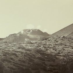
Silvestri, O.
Etna. Eruzione e terremoti del Maggio-Giugno 1879. Fotografie fatte per incarico del R. Governo Italiano sotto la direzione del Prof. Orazio Silvestri.
[Catania], A. T. Tagliarini, "1879" [1880]. Oblong folio, with 30 (of 33 or 34?) original albumen prints of slightly variable size, on average 17.5 x 32.0 cm (plates 1-22), or four times 19 x 24 cm (plates 23-24), all mounted on 24 (of 25?) very large printed boards, each 48.5 x 56.8 cm and with a gilt frame of 29.2 x 39.1 cm (plates 1-22), or four times 20.4 x 25.8 cm (plates 23-24) with printed captions mounted, and printed captions on the boards. In clamshell box of navy pebbled cloth over marbled boards (58.3 x 51.4 x 3.7 cm) with original printed labels on the front board recto and verso.
Read more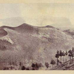
Berthier, P. [M.]
Photographic panorama of Mount Etna.
Paris, Paul Berthier, 1865. Very large board (93.0 x 45.0 cm), with original mounted albumen silver prints (panorama, in two parts of 25.0 x 36.2 cm and 25.0 x 35.0 cm, for a continuous image with a total width of 71.2 cm). Paul Berthier printed studio label pasted on verso.
Read more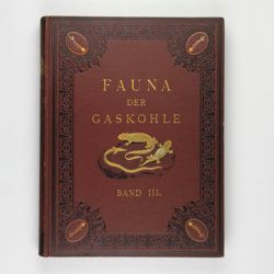
Fritsch, A.
Fauna der Gaskohle und der Kalksteine der Permformation Böhmens. Band I-IV. [Complete].
Prag, Selbstverlag and F. Řivnáč, 1879-1899 [1901?]. Four volumes in four. Folio (34.0 x 25.5 cm). 459 pp., lavishly illustrated with 167 mostly chromolithographed plates (several double-sized or larger, folded), and over 400 text engravings, of which some plate-sized. Volume I (1883): 182 pp., 48 plates (some larger, folded, a few plain), 160 text engravings; volume II (1889): 114 pp., 44 plates (several larger, folded; numbered 49-90, 80b, 81b), 79 text figures (numbered 117-188); vol. III (1895): 132 pp., 42 plates [several (much) larger; numbered 91-132], 122 text engravings (numbered 189-310); vol. IV (1901): 101 pp., full colour frontispiece, of a landscape with "Miriopoden"; 33 plates (numbered 133-165), 64 text engravings (numbered 311-394, and including phototypes of fossil animals and tracks, freshwater bivalves, and, e.g. the author at work). Original uniform brown cloth sumptuously embossed with black floral borders, and gilt vignettes depicting Permian amphibians, reptiles and fish. Marbled edges.
Read more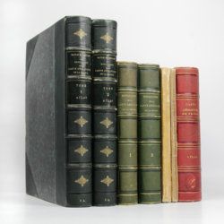
Dufrenoy, [O. P. A.] and [J. B. A. L. L.] Élie de Beaumont
Explication de la carte géologique de la France. Volumes I-IV (text and atlas), and two maps. [Complete].
Paris, Imprimerie Royale, Imprimerie Nationale, 1841-1879. Four volumes in seven, and a large map in six folded sheets, each ca. 70 x 205 cm (including borders) with linen covers. Large 4to (four text volumes; ca. 27.5 x 21.0 cm); folio (two atlas volumes, 26.8 x 35.7 cm). Tome premier: Paris, Imprimerie Royale, 1841. Large 4to. xxii, 825 pp., 71 text engravings (mainly profiles); Tome deuxième: Paris, Imprimerie Nationale, 1848. Large 4to. xii, 813 pp., 105 text engravings (mainly views and profiles), one large, folded chromolithographed geological map (finished by hand) of France (printed surface: 57 x 54 cm, and consisting of 15 smaller sections, mounted on linen and folded) bound in the rear; Tome troisième. Première partie (by Dufrénoy): Paris, Imprimerie Nationale, 1873. Large 4to. viii, 231 pp., 18 text engravings (mainly profiles). Printed wrappers. Tome quatrième. Seconde partie. Végétaux fossiles du terrain houiller (by Zeiller): Paris, Imprimerie Nationale, 1879. Large 4to. 185 pp. Printed wrappers; Tome quatrième. Atlas (in two volumes). Première partie. Fossiles principaux des terrains (by É. Bayle). Seconde partie. Végétaux fossiles du terrain houiller (by Zeiller): Paris, Imprimerie Nationale, 1878. Folio. Title page, half title to first part. 86 lithographed plates with explanatory text leaves, numbered I-LXXXVI; 90 lithographed plates with explanatory text leaves, numbered LXXXVII-CLXXVI (the last 16 on plants), for a total of 176 plates. Volumes I, II, and IV plate volumes in near uniform contemporary dark-green pebbled morocco over marbled boards. Spines with five gilt-stippled bands, and gilt title. Marbled endpapers. The text volumes with top edge gilt, atlases with marbled top edges. Text volumes III and IV in original printed wrappers. The large chromolithographed map in six sheets (approximately 218 x 223 cm) is contained in a contemporary, book-like crimson box with gilt-lettered spine, with raised bands and patterned paper sides.
Read more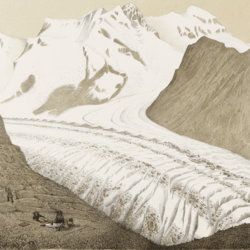
Agassiz, L.
Untersuchungen über die Gletscher. [Complete text and atlas].
Solothurn, Jent & Gassmann, 1840-1841; Neuchatel, H. Nicolet, 1840. Text: 8vo (21.5 x 14.2 cm). xii, 326, [i] pp. 19th-century pebbled half cloth over marbled boards. Spine with gilt ornamental bands and title. Greenish endpapers. Subtly marbled edges. Atlas: Oblong folio (29.7 x 44.0 cm). 18 lithographed plates of which 14 with printed overlays (as intended). Contemporary green quarter calf over green boards. Spine with gilt bands. Original pictorial title mounted on front board.
Read more
[Various authors]
Annales des Mines. Series III-VI. Atlases.
Paris, Ecole de Mines, 1832-1866. Two series in four. Oblong folio (40.5 x 22.0 cm) with 758 (of 759? see below) engraved and lithographed plates and maps, of which 29 are hand-coloured geological maps or profiles. Contemporary uniform red cloth. Gilt titles on the spines and front boards. Marbled endpapers.
Read more
Robert, E. [Gaimard]
Voyage en Islande et au Groënland executé pendant les années 1835 et 1836 sur la corvette La Recherche commandée par M. Tréhouart Lieutenant de Vaisseau dans le but de découvrir les traces de La Lilloise. Publié par ordre du Roi sous la direction de M. Paul Gaimard président de la Commission Scientifique d'Islande et de Groënland. Minéralogie et géologie.
Paris, Arthus Bertrand, 1838-1840. Two parts in one. Large 8vo (22.7 x 15.1 cm). Title page (to the text, dated 1840), xi, 469 pp.; second title page (to the atlas, dated 1838), [ii] pp., 36 lithographed plates. Contemporary quarter morocco over marbled boards. Spine rich gilt. Marbled endpapers. Speckled edges.
Read more
Fuchs, W.
Die Venetianer Alpen. Ein Beitrag zur Kenntniss der Hochgebirgte, met einen geognostischen Karte und Gebirgteprofilen in achtzehn Tafeln.
Solothurn, Jent & Gassmann, 1844. Oblong folio (29.8 x 35.5 cm), [4], 60 pp.; 18 mostly hand-coloured engraved maps and plates. Text pages bordered with putti and goddesses. 19th century iridescent blue blind cloth.
Read more
Lecoq, H.
Les époques géologiques de l'Auvergne. Avec 170 planches ou figures, dont plusieurs coloriées et des autographes de Dolomieu, d'Hauy & de De Saussure et un dessin fac simile de Madame Necker de Saussure. I-V. [Complete].
Paris, Baillière et fils, 1867. Five volumes in five. Large 8vo (23.7 x 15.2 cm). 2,758 pp.; 180 engraved and lithographed (tinted, or chromolithographed) plates [1-141, 143-169, 41(bis), 57(bis), 89bis, 107(bis), 149bis, 152bis, 163bis, 163ter, 165bis, 165ter, 165quater, 165quinter], on 107 sheets (several double-sized). Uniform burgundy half morocco over marbled boards. Spines with five raised bands, gilt title. Marbled endpapers. Speckled edges.
Read more
[Geological map]
Geognostische Karte von Württemberg [AND] Begleitworte zur geognostischen Specialkarte von Württemberg.
Stuttgart, Das Königliches Statistisch-topographisches Bureau, Kohlhammer, Kleeblatt, 1863-1892. With 54 chromolithographed folded geological maps, all mounted on linen, numbered 1-48, 50-55, in two original, uniform burgundy boxes with gilt title on the lid. [AND] the "Begleitworte" 34 parts in one. Large 8vo (25.7 x 19.5 cm). Stuttgart, Königlich Statistischen Landesambt, (1865-1892). ca. 1,000 pp., and five hand-coloured wood-engraved or lithographed maps or geological profiles, and four wood-engraved plates. Contemporary half cloth over marbled boards. Spine with gilt title, ornaments, and the Württemberg coat-of-arms; patterned endpapers, and marbled edges.
Read more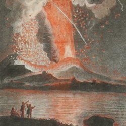
Torcia, M.
Relazione dell'ultima eruzione del Vesuvio. Accaduta nel mese di agosto di questo anno 1779. Rélation de la dernière éruption du Vésuve. Arrivée au mois d'Août de cette année 1779.
Napoli, Raimondi, 1779. 8vo (18.6 x 12.0 cm). Two title pages (Italian and French) with different engraved vignettes, [vi], 135 pp. (separated by a blank page), one folded engraved view of the eruption engraved by Boilly and nicely hand-coloured by Volaire. Contemporary vellum. Spine with gilt-lettered label.
Read more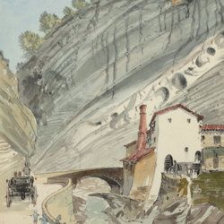
["JAM" (R. de Bouillé, Comte)]
[Original watercolour sketches of French landscapes]
[France], no place, no publisher, ca. 1863-1890. 13 oblong sheets (22.3 x 29.2 cm), all with fine watercolour paintings, either full-sized, or smaller, in a drawn rectangular frame. And one drawing on slightly smaller paper, more sketchy, in pencil.
Read more
Titsingh, [I.]
Mémoires et anecdotes sur la dynastie régnante des djogouns, souverains du Japon, avec la description des fêtes et cérémonies observées aux différentes epoques de l'année a la cour de ces princes, et un appendice contenant des détails sur la poésie des Japonais, leur manière de diviser l'année, etc; ouvrage orné de planches gravées et coloriées, tiré des originaux Japonais par M. Titsingh; publié avec les notes et éclaircissemens par M. Abel Rémusat.
Paris, A. Nepveu, 1820. 8vo (19.3 x 12.0 cm). xxviii, 302 pp.; one hand-coloured folded frontispiece, one engraved folded table, five hand-coloured folded plates. Contemporary full tree calf. Spine rich gilt including empire vignettes and a red morocco label with gilt title. Marbled endpapers. Edges speckled.
Read more
Schmidt, R. R.
Die diluviale Vorzeit Deutschlands.
Stuttgart, E. Schweizerbart (Nägele und Dr. Sproesser), 1912. Very large 4to (35.5 x 30.0 cm). xiii, 283 pp.; 47 engraved or heliogravure plates with explanatory text leaves, loose in rear pocket. Original quarter vellum over cloth boards. Gilt title on front board; gilt-lettered morocco label on the spine.
Read more
Lacroix, A.
Mineralogie de Madagascar. Tomes I-II-III. [Complete].
Paris, Augustin Challamel, 1922-1923. Three parts in three. 4to (27.1 x 21.3 cm). 1,799 [xvi, 624; vii, 694; viii, 450] pp.; 540 text illustrations [504; 11; 25], 64 plates [27; 29; 8], one tinted double-sized geographical map of Madagascar, Mayotte, and the Comores (in volume I), one very large, multi-folded full colour geological map (in volume III). Uniform contemporary red buckram. Spines with gilt title. Marbled endpapers. Speckled edges.
Read more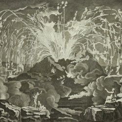
Diderot, D. and J. d'Alembert (eds.)
Encyclopédie ou dictionnaire raisonné des sciences, des arts et des métiers, par une société de gens de lettres mis en ordre par Mons. Diderot. Histoire naturelle. Règne mineral.
Paris, Diderot et d'Alembert, 1768. Folio (43.2 x 27.2 cm). 4 pp., 130 plates (partly folded). Disbound.
Read more
Dolomieu, D. [S. G. T.], De
Reise nach den liparischen Insuln oder Nachricht von den äolischen Insuln zur nähern Aufklärung der Geschichte der Vulkane. Nebst einer Abhandlung über eine Art von Luftvulkan, und einer andern über die Temperatur des Clima auf Maltha und die Verschiedenheit der wahren und fühlbaren Wärme.
Leipzig, Johann Gottfried Müller, 1783. 8vo (16.7 x 10.1 cm). 210, [ii] pp. Contemporary marbled boards, small leather label with gilt title on the spine. Edges yellow.
Read more
Guettard, J. E.
Histoire de l'Academie Royale des sciences, Année MDCCLI [1751], avec les mémoires de mathématique & de physique, pour la même année. Tirés des registres de cette académie.
Paris, l'Imprimerie Royale, 1755. 4to (25.1 x 18.9 cm). 738 [202, 536] pp.; 23 mostly large, folded plates. Contemporary full tree-calf. Spine with five raised bands, gilt title and gilt vignettes. Marbled endpapers. Red edges.
Read more
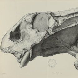
Owen, R.
Descriptive and illustrated catalogue of the fossil Reptilia of South Africa in the collection of the British Museum.
London, The Trustees of the British Museum, 1876. Folio (32.5 x 25.2 cm). xii, 88 pp.; 70 fine lithographed plates, several larger, and folded. Original green pebbled and blind-tooled cloth. Gilt title on the spine.
Read more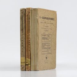
Tokunaga, S. et al.
Report of the First Scientific Expedition to Manchoukuo. Under the leadership of Shigeyasu Tokunaka. June - October 1933. Section II [Geology]. Part I-IV. [Complete].
Tokyo, Asahi, 1934-1939. Four volumes in four. 4to (26.0 x 19.0 cm). Ca. 700 pp. with 124 plates and three folding coloured maps. Original uniform printed stiff wrappers.
Read more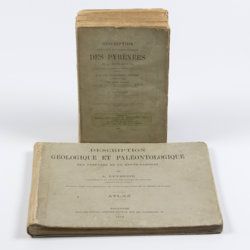
Leymerie, A. [F. G. A.]
Description géologique et paléontologique des Pyrenées de la Haute-Garonne accompagnée d'une carte topographique et géologique à l'echelle 1:200.000 et d'un Atlas...
Toulouse, Privat, 1878, 1881. In two volumes. Text (1881) 8vo (24.0 x 16.0 cm). Atlas (1878) oblong 4to (23.5 x 31.5 cm). 1,027 pp.; 51 lithographed plates of which 11 tinted or coloured (and of which 30 are on fossils), including a large folded transection of the Pyrenees, Haute Garonne, and the large coloured geological map (with 20 colours) mounted on linen. Original printed wrappers (text) and boards (atlas).
Read more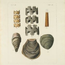
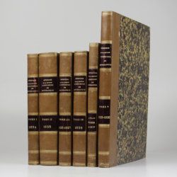
[Various geologists and palaeontologists]
Mémoires de la Société Linnéenne de Normandie. Volumes I-V. [IINCLUDING Société Linnéenne de Calvados].
Caen, Société Linnéenne de Normandie, 1824-1835. Five volumes in six. 8vo (volumes I-IV, 21.0 x 13.2 cm), 4to (volume V, 27.6 x 22.0 cm), and oblong folio (atlas to volumes II-IV, 22.5 x 31.0 cm). Title pages; 15 lithographed (partly folded) plates in volume I, one hand-coloured geological map, 39 lithographed plates in the atlas volume, mainly depicting lichens by Delise, and geological maps (11 hand-coloured). Uniform later half calf over marbled boards. Spines with gilt title.
Read more
