General Earth Sciences - Geology
48 items found
Rothpletz, A.
Ein geologischer Querschnitt durch die Ost-Alpen nebst Anhang über die sog. Glarner Doppelfalte.
Stuttgart, E. Schweizerbart (E. Koch), 1894. 8vo (22.4 x 15.4 cm). iv, 208 pp.; two full colour folded profiles of which one measuring 22.5 x 352.0 cm (!), 115 text illustrations. Contemporary half cloth over marbled boards. Gilt lines and two red morocco labels with gilt title on the spine. Edges speckled.
Read more
[Bertrand, B. N.]
Elemens d'oryctologie ou distribution méthodique des fossiles.
Neuchatel, Société Typographique, 1773. 8vo (18.8 x 11.5 cm). xxxix, 137, xxii pp.; 16 double, folded tables. Contemporary full calf. Spine with four raised bands. Rich gilt floral compartments, red morocco label with gilt title. Edges red.
Read more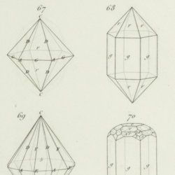
Rose, G.
Eléments de cristallographie.
Paris, Hachette et Firmin Didot, 1834. 8vo (19.9 x 12.7 cm). 270 pp.; title page (to IIe partie - planches), 12 pp.; 10 double-sized engraved plates with 121 figures, numbered 1-108 (plates I-IX), and 1-13 (plate X). Contemporary half calf over marbled boards. Spine with gilt lines and title. Marbled endpapers.
Read more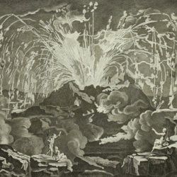
Diderot, D. and J. d'Alembert (eds.)
Encyclopédie ou dictionnaire raisonné des sciences, des arts et des métiers, par une société de gens de lettres mis en ordre par Mons. Diderot. Histoire naturelle. Règne mineral.
Paris, Diderot et d'Alembert, 1768. Folio (43.2 x 27.2 cm). 4 pp., 130 plates (partly folded). Disbound.
Read more
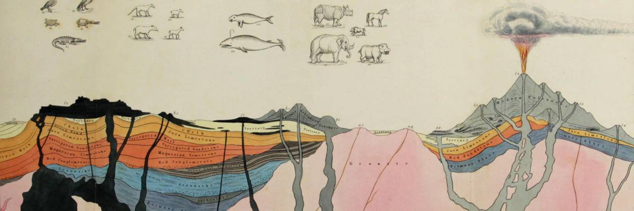
Devèze de Chabrol, J. S. and J. B. Bouillet
Essai géologique et minéralogique sur les environs d'Issoire, département du Puy-de-Dôme, et principalement sur la Montagne de Boulade.
Clermont-Ferrand, Thibaud-Landriot, 1827. Folio (41.0 x 26.2 cm). xii, 104 pp.;hand-coloured lithographed geological map and hand-coloured profile, and 30 lithographed plates depicting vertebrates and several tables, including one very large, folded in the text. Contemporary half morocco over marbled boards. Spine with gilt lines and title. Marbled endpapers; speckled edges.
Read more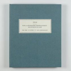
Cuvier, G. and A. [T.] Brongniart
Essai sur la géographie minéralogique des environs de Paris. Proof copy of the introductions, with corrections by Brogniart.
Paris, Institut Impériale de France, [1809 or 1810]. 4to (25.0 x 20.0 cm). 33 pp. Not bound. In a 20th century blue hardcover paper drop-box (26.8 x 22.0 cm) with printed label on the top board.
Read more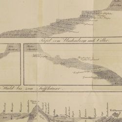
Oeynhausen, C. von and H. von Dechen and H. von La Roche
Geognostische Umrisse der Rheinländer zwischen Basel und Mainz mit besonderer Rücksicht auf das Vorkommen des Steinsalzes, nach Beobachtungen entworfen auf einer Reise im Jahre 1823 gesammelt.
Essen, G. Bädeker, 1825. Two volumes in one. 8vo (19.8 x 12.0 cm). 782 pp.; one folding lithographed plate with several geological profiles. Contemporary half cloth over marbled boards. Paper label with the title in an old hand on the spine. Original endpapers.
Read more
Allemann, F.
Geologische Karte Fürstentum Liechtenstein.
[Vaduz], Regierung des Fürstentums Liechtenstein, 1953. Large (102.0 x 67.0 cm), folded map, consisting of 25 rectangular sheets in full colour, mounted on linen. Handwritten and stamped label on the front-facing part of the linen map verso.
Read more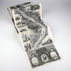
Arnold, F.
Halenza's neuestes Rhein-Panorama von Mainz bis Cöln. Einziges, durch die Berliner und Frankfurter Künstler gefässtes Urtheil, anerkanntes Kustwerk. Panorama du Rhin depuis Mayence jusq'à Cologne. Panorama of the Rhine, from Mentz to Cologne. [Complete with the rare text volume].
Mainz, J. Halenza, [1880]. Two parts in two. 8vo (text: 26.4 x 16.2 cm). Title page, 24 pp. (in English). Panorama: One folding lithographed view by F. Foltz (27 x 230 cm). Contained in original printed boards with the German title on one board, and the French/English titles on the other.
Read more
Widenmann, J. F. W.
Handbuch des oryktognostischen Theils der Mineralogie.
Leipzig, Siegfried Lebrecht Crusius, 1794. Thick 8vo (19.6 x 12.2 x 6.0 cm). xiv, [vi], 1,040, [4], [xv] pp.; two folded engravings, one with 74 different colours. Contemporary marbled boards. Spine with gilt lines and morocco label with gilt title. All edges red.
Read more
Torre, G. M. Della
Histoire et phénomènes du Vésuve. Exposés par le Pere Dom Jean-Marie Della-Torre, clerc régulier sommasque, garde bde la bibliothéque & du cabinet du roi des Deux-Siciles, & correspondant de l'Académie Royale des Sciences de Paris. Traduction de l'Italien par M. l'abbé Péton.
Paris, Jean-Thomas Hérissant, 1760. 12mo (16.3 x 9.2 cm). xxiv, 399 pp., one large folded map of Mount Vesuvius, the Bay of Naples and surroundings, and five folded plates with panoramas and other views of the volcano, caldera, etc. Contemporary full mottled calf. Spine with five raised bands. Compartments with gilt floral vignettes and small red morocco label with gilt title. Marbled endpapers, marbled edges.
Read more
Sonnini, C. S.
Histoire naturelle générale et particulière, par Leclerc de Buffon; nouvelle edition accompagnée de notes, et dans laquelle les supplémens sont insérés dans le premier texte, à la place qui leur convient. Ouvrage formant un cours complet d'histoire naturelle; redige par C. S. Sonnini, membre de plusieurs sociétés savantes. Tomes Mineraux 1-16. [Théorie de la terre 1-3; Epoques de la nature; Introduction a l'histoire des minéraux 1-3; Mineraux 1-9].
Paris, Dufart, An VIII (1798) - X (1800). 16 parts in 16. 8vo (19.5 x 12.2 cm). Engraved frontispiece, 7156 pp.; nine engraved plates, four folded maps. Contemporary uniform full tree calf. Boards with gilt ornamented borders and gilt dentelles. Rich gilt spines, gilt titles on two (red and black) morocco labels, marbled flyleaves, all edges speckled red on yellow.
Read more
