
Geography
42 items found
Zannoni, R.
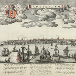
Atlas historique de la France ancienne et moderne contenant tous les lieux illustrés par les événements les plus mémorables de notre histoire; ... depuis Pharamond jusqu'a Louis XV....
Paris, S. Desnos, 1782. Large 4to (28.8 x 22.2 cm). Beautifully engraved double-sized title page; similar folding dedication page (by Desnos and Zannoni), 16 pp.; 59 hand-coloured engraved maps (56 double-sized with ornamental borders; two much larger, of which one dated 1774, and the other 1776). Contemporary half calf over marbled boards. Spine with five raised bands; compartments with gilt floral patterns and red morocco label with gilt title. Edges red.
Read more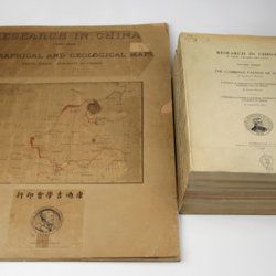
Willis, B. (ed.)
Research in China. In three volumes and atlas. 1(1). Descriptive topography and geology; 1(2). Petrography and zoology; 2. Systematic geology; 3. The Cambrian faunas of China. A report on Ordovician fossils collected in eastern Asia in 1903-04. A report on Upper Paleozoic fossils collected in China 1903-04; [4.] Geographical and geological maps. [Complete].
Washington, DC, The Carnegie Institution of Washington, 1907-1913. In five parts (four text and plate volumes, one atlas). 4to (29.8 x 24.0 cm). Text; 101 plates, including six chromolithographs of birds, and geological maps; folio atlas (52.7 x 45.0 cm) with 42 mostly coloured geological and topographical maps (some with explanatory text or figures). Original printed wrappers.
Read more
Clairaut, J. B., a.o.
Miscellanea Berolinensia ad incrementum scientiarum ex scriptis Societati Regiae Scientiarum exhibitis. Edita, continuatio III, sive Tomus IV. Cum figuris et indice materiarum.
Berolini, Johann Andreas Rüdiger, 1734. Small 4to (20.5 x 16.0 cm). vi, 405 pp.; 11 mostly folded engraved plates. Contemporary full mottled calf. Spine with five raised, gilt-ornamented bands; compartments rich gilt, red morocco label with gilt title. Edges speckled red.
Read more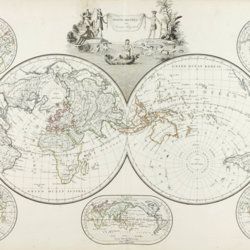
Malte-Brun, [C.]
Précis de la géographie universelle, ou description de toutes les partes du monde, sur un plan nouveau d'après les grandes divisions naturelles du globe. Précédée de l'histoire de la géographie chez les peuples anciens et modernes, et d'une théorie générale de la géographie mathématique, physique et politique. Collection de cartes géographiques. [AND] Atlas supplémentaire du Précis de la géographie universelle de M. Malte-Brun; dressé conformément au texte de cet ouvrage et sous les yeax de l'auteur, par M. Lapie, capitaine ingénieur géographie. [Atlases].
Paris, François Buisson, 1810-1812. Two parts in one. Folio (34.0 x 25.8 cm). Title pages, 14 pp. [ii; 12]; 75 [24; 51] engraved and hand-coloured maps. 19th-century black quarter calf over black pebbled boards. Spine with four slightly raised, gilt-lined bands; compartments with triple-gilt borders and title. Marbled endpapers. All edges gilt.
Read more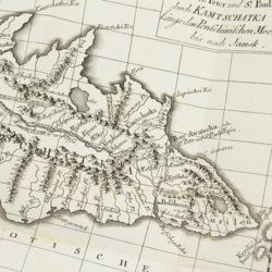
Lesseps, [J. B. B.] de
Herrn von Lesseps Gefährten des Grafen de la Perouse Reise durch Kamtschatka und Sibirien nach Frankreich. Aus dem Französischen übersetzt. Mit Anmerkungen von Johann Reinhold Forster.
Berlin, Voss, 1791. 8vo (22.4 x 14.5 cm). xxviii, 302 [303-544] pp.; two engraved, folded maps, one folded table. Original blind boards.
Read more
Lecoq, H.
[Auvergne] Itinéraire de Clermont au Puy de Dome, ou description de cette montagne et de la Vallée de Royat et Fontanat; seconde edition. [AND] Two other papers on the geology of Auvergne, by A. C. P. F. Von Lasaulx, and by J. B. Bouillet, bound in.
Paris, J. B. Baillière, 1836. 8vo (21.2 x 13.3 cm). vi, 102 pp. Early 20th century half morocco over marbled boards. Spine with five raised bands and gilt title. Marbled endpapers.
Read more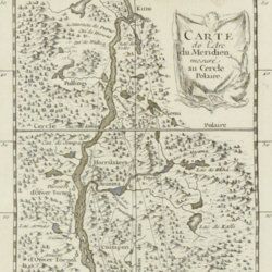
Maupertuis, P.L. Moreau de
Sur la Figure de la Terre déterminée par Messieurs de l'Académie royale des Sciences, qui ont mesuré le degré du méridien au Cercle Polaire.
Paris, l'Imprimérie Royale, 1740. 4to (25.8 x 20.2 cm). pp. 90-96; 389-469 In: Histoire de l'Académie royale des Sciences Année MDCCCXXXVII. Engraved allegorical frontispiece; title page; [vi], 120, 492 pp.; engraved map of Lapponia; five engraved, folded plates. Contemporary full polished calf. Boards with double gilt borders; spine with five raised bands, gilt floral patterns and two red morocco labels with gilt title. Gilt floral inner dentelles. Marbled endpapers. Mottled edges.
Read more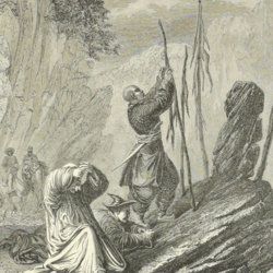
[Przewalski] Von Prschewalskij, N.
Reisen in der Mongolei, im Gebiet der Tanguten und den Wüsten Nordtibets in den Jahren 1870 bis 1873.
Jena, Hermann Costenoble, 1877. Large 8vo (21.9 x 14.1 cm). xl, 538 pp.; one coloured lithographed folding map and ten engraved plates and several text engravings. Contemporary half morocco over marbled boards. Spine with red, gilt-bordered label, title in gilt.
Read more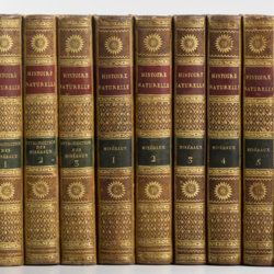
Sonnini, C. S.
Histoire naturelle générale et particulière, par Leclerc de Buffon; nouvelle edition accompagnée de notes, et dans laquelle les supplémens sont insérés dans le premier texte, à la place qui leur convient. Ouvrage formant un cours complet d'histoire naturelle; redige par C. S. Sonnini, membre de plusieurs sociétés savantes. Tomes Mineraux 1-16. [Théorie de la terre 1-3; Epoques de la nature; Introduction a l'histoire des minéraux 1-3; Mineraux 1-9].
Paris, Dufart, An VIII (1798) - X (1800). 16 parts in 16. 8vo (19.5 x 12.2 cm). Engraved frontispiece, 7156 pp.; nine engraved plates, four folded maps. Contemporary uniform full tree calf. Boards with gilt ornamented borders and gilt dentelles. Rich gilt spines, gilt titles on two (red and black) morocco labels, marbled flyleaves, all edges speckled red on yellow.
Read more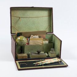
Travelling writer's kit
Travelling writer's kit with stationery and miniature globe.
Paris, ca. 1915-1925. Portable red cardboard box (28.0 x 16.9 x 14.3 cm) embossed with maroon reptile-skin patterned paper with gilt title "Papeterie" and vignette, and simple brass lock. Inside covered with decorative green-with-black-cobweb patterned paper.
Read more
Unger, F.
Ueber den Einfluss des Bodens auf die Vertheilung der Gewächse nachgewissen in der Vegetation des nordöstlichen Tirols.
Wien, Rohrmann und Schweigerd, 1836. 8vo (21.4 x 13.5 cm). xxiv, 367 pp.; one hand-coloured engraved plate of Kitzbühl, one large, folded, hand-coloured geological-geographical map, one large, folded hand-coloured sheet with geological profile, five folded charts with meteorological observations (four) and botanical observations (one), many tables in the text. Contemporary quarter calf over marbled boards. Spine with gilt lines, vignettes, and title. Marbled endpapers; speckled edges.
Read more
