
Geography
42 items found
Clairaut, J. B., a.o.
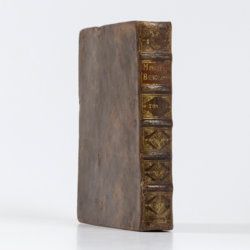
Miscellanea Berolinensia ad incrementum scientiarum ex scriptis Societati Regiae Scientiarum exhibitis. Edita, continuatio III, sive Tomus IV. Cum figuris et indice materiarum.
Berolini, Johann Andreas Rüdiger, 1734. Small 4to (20.5 x 16.0 cm). vi, 405 pp.; 11 mostly folded engraved plates. Contemporary full mottled calf. Spine with five raised, gilt-ornamented bands; compartments rich gilt, red morocco label with gilt title. Edges speckled red.
Read more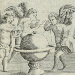
Grandami, J.
Nova demonstratio immobilitatis terrae petita ex virtut magnetica. Demonstratio immobilitatis terrae. Terra in aeternum stat. Aequivaletia longitudinum. Meridianus universalis sine declinatione.
La Flèche, George Griveau, 1645. Small 4to (20.0 x 15.3 cm). Engraved title page, [vi], 162 pp. [1-24; 33-170]; six engraved plates (of which three larger, folded), 23 (groups of) large, engraved text illustrations (some occupying a whole page), one table in the text. Early to mid-19th century polished quarter calf over marbled boards. Spine with gilt lines and ornaments, and two red morocco labels with gilt title and date. Red edges.
Read more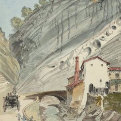
["JAM" (R. de Bouillé, Comte)]
[Original watercolour sketches of French landscapes]
[France], no place, no publisher, ca. 1863-1890. 13 oblong sheets (22.3 x 29.2 cm), all with fine watercolour paintings, either full-sized, or smaller, in a drawn rectangular frame. And one drawing on slightly smaller paper, more sketchy, in pencil.
Read more
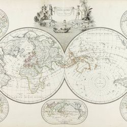
Malte-Brun, [C.]
Précis de la géographie universelle, ou description de toutes les partes du monde, sur un plan nouveau d'après les grandes divisions naturelles du globe. Précédée de l'histoire de la géographie chez les peuples anciens et modernes, et d'une théorie générale de la géographie mathématique, physique et politique. Collection de cartes géographiques. [AND] Atlas supplémentaire du Précis de la géographie universelle de M. Malte-Brun; dressé conformément au texte de cet ouvrage et sous les yeax de l'auteur, par M. Lapie, capitaine ingénieur géographie. [Atlases].
Paris, François Buisson, 1810-1812. Two parts in one. Folio (34.0 x 25.8 cm). Title pages, 14 pp. [ii; 12]; 75 [24; 51] engraved and hand-coloured maps. 19th-century black quarter calf over black pebbled boards. Spine with four slightly raised, gilt-lined bands; compartments with triple-gilt borders and title. Marbled endpapers. All edges gilt.
Read more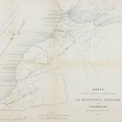
Tissot, C. [J.]
Recherches sur la géographie comparée de la Maurétanie tingitane.
Paris, Académie des Inscriptions et Belles-Lettres, 1877. 4to (27.8 x 22.1 cm). 184 pp. [numbered 139-322]; six maps and plates, including a very large, multifolded map of Morocco and adjacent areas. Original blue wrappers with printed label on the spine.
Read more
Dolomieu, D. [S. G. T.], De
Reise nach den liparischen Insuln oder Nachricht von den äolischen Insuln zur nähern Aufklärung der Geschichte der Vulkane. Nebst einer Abhandlung über eine Art von Luftvulkan, und einer andern über die Temperatur des Clima auf Maltha und die Verschiedenheit der wahren und fühlbaren Wärme.
Leipzig, Johann Gottfried Müller, 1783. 8vo (16.7 x 10.1 cm). 210, [ii] pp. Contemporary marbled boards, small leather label with gilt title on the spine. Edges yellow.
Read more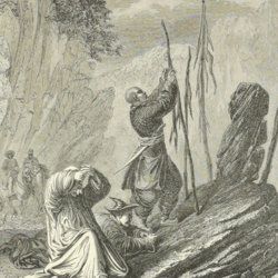
[Przewalski] Von Prschewalskij, N.
Reisen in der Mongolei, im Gebiet der Tanguten und den Wüsten Nordtibets in den Jahren 1870 bis 1873.
Jena, Hermann Costenoble, 1877. Large 8vo (21.9 x 14.1 cm). xl, 538 pp.; one coloured lithographed folding map and ten engraved plates and several text engravings. Contemporary half morocco over marbled boards. Spine with red, gilt-bordered label, title in gilt.
Read more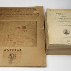
Willis, B. (ed.)
Research in China. In three volumes and atlas. 1(1). Descriptive topography and geology; 1(2). Petrography and zoology; 2. Systematic geology; 3. The Cambrian faunas of China. A report on Ordovician fossils collected in eastern Asia in 1903-04. A report on Upper Paleozoic fossils collected in China 1903-04; [4.] Geographical and geological maps. [Complete].
Washington, DC, The Carnegie Institution of Washington, 1907-1913. In five parts (four text and plate volumes, one atlas). 4to (29.8 x 24.0 cm). Text; 101 plates, including six chromolithographs of birds, and geological maps; folio atlas (52.7 x 45.0 cm) with 42 mostly coloured geological and topographical maps (some with explanatory text or figures). Original printed wrappers.
Read more
Lovassy, A.
Resultate der wissenschaftlichen Erforschung des Balatonsees. Mit Unterstützung der hohen Kön. Ung. Ministerien für Ackerbau und für Cultus und Unterricht. Zweiter Band. Die Biologie des Balatonsees und seiner Umgebung. Zweiter Theil. Die Flora. II. Sektion. Die Pflanzengeographischen Verhältnisse der Balatonsee-Gegend. Anhang. Die trophischen Nymphaeen des Hévizsees bei Keszthely.
Wien, Ed. Hölzel, 1909. Large 4to (29.3 x 21.2 cm). 91 pp.; four plates of which three in chromolithography. Original printed wrappers.
Read more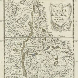
Maupertuis, P.L. Moreau de
Sur la Figure de la Terre déterminée par Messieurs de l'Académie royale des Sciences, qui ont mesuré le degré du méridien au Cercle Polaire.
Paris, l'Imprimérie Royale, 1740. 4to (25.8 x 20.2 cm). pp. 90-96; 389-469 In: Histoire de l'Académie royale des Sciences Année MDCCCXXXVII. Engraved allegorical frontispiece; title page; [vi], 120, 492 pp.; engraved map of Lapponia; five engraved, folded plates. Contemporary full polished calf. Boards with double gilt borders; spine with five raised bands, gilt floral patterns and two red morocco labels with gilt title. Gilt floral inner dentelles. Marbled endpapers. Mottled edges.
Read more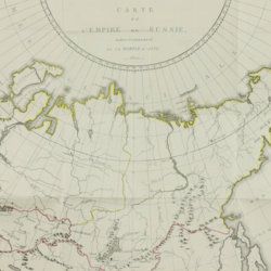
Storch, H.
Tableau historique et statistique de l'empire de Russie à fin du dix-huitième siècle. Edition française.
Basle, J. Decker, and Paris, C. Pougens, 1801. Two volumes in two. 8vo (19.6 x12.3 cm). 1,004 pp. [xxii, 407, 80; 423, 72]; two large, partly coloured folded maps (the largest with printed dimensions 67 x 36.5 cm), three folded tables. Uniform contemporary tree-calf. Spines rich gilt with gilt title on blue morocco label. Marbled endpapers. Edges yellow, speckled with red.
Read more
