
Regional Earth Sciences - Geology
69 items found
Rey, G.
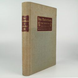
Das Matterhorn. Vorwort von E. de Amicis with geologische Erläuterungen by V. Novarese.
Stuttgart and Leipzig, Deutsche Verlags-Anstalt, 1905. 4to (29.2 x 21.0 cm). xi, 258 pp.; 35 plates of which 14 are nicely tinted photographic plates after water-colours, mounted on black paper, all by Edoardo Rubino and 11 photographs (most by Vittorio Sella and a few by G. Rey) and ten photographic plates from drawings also by Edoardo Rubino. Furthermore there are 13 images of drawings in the text also by Edoardo Rubino [complete]. Original cloth with bevelled edges, gilt mounted title piece on front board and gilt-lettered spine label. Mottled olive endpapers. Top edge gilt.
Read more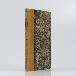
Bonnard, A. H. De
Sur la constance des faits géognostiques, qui accompagnent le gisement du terrain d'Arkose à l'est du Plateau Central de la France.
Paris, Mme Huzard, 1828. 8vo (21.5 x 13.3 cm). 106 pp.; three folded engraved geological profiles. Contemporary polished half calf. Spine with five raised, gilt-bordered bands and gilt title on red morocco shield. Marbled flyleaves.
Read more
Granö, J. G.
Beiträge zur Kenntnis der Eiszeit in der Nordwestlichen Mongolei und einigen ihrer südsibirischen Grenzgebirge. Geomorphologische Studien aus den Jahren 1905, 1906, 1907 und 1909.
Helsingfors, J. Simelii [for the Geographical Society of Finland], 1910. Large 8vo (24.9 x 16.5 cm). iv, 230 pp.; seven large, folded coloured maps, 19 photographic plates. Later quarter calf over pictorial boards.
Read more
Passy, A. [F.]
Description géologique du département de la Seine-Inférieure. [Text and Atlas].
Rouen, Nicétas Periaux, 1832. Two parts [text and atlas] in one. 4to (26.7 x 21.3 cm). 402 pp. [xvi, 371; 15]; 20 engraved plates (several double-sized), of which 15 in original hand-colouring. Contemporary quarter morocco over marbled boards; spine with gilt title. Marbled endpapers.
Read more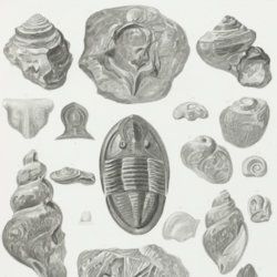
Owen, D. D.
Report of a geological survey of Wisconsin, Iowa and Minnesota; and incidentally of a portion of Nebraska territory. Made under instructions from the United States Treasury Department [AND] Illustrations to the geology report of Wisconsin, Iowa, and Minnesota.
Philadelphia, PA, Lippincott, Grambo & Co., 1852. Two parts in two. 4to (31.1 x 23.0 cm). Engraved frontispiece and title page, 639 pp. (first xxxviii in Roman numbers), numerous fine steel-engravings (text volume); title page, 27 (I-XV, IA-D, IIA-B, IIIA, VA-B, VIIIA, XIIA-B) fine lithographed plates with explanatory text leaves, and 21 mostly folding (all but two) and (partly) hand-coloured (all but two) geological maps, views, and profiles (atlas volume). Original near uniform blind-tooled cloth. Text volume spine with gilt title, plate volume with gilt title on the front board.
Read more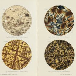
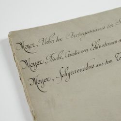
Meyer, H. von
Ueber den Archegosaurus der Steinkohlenformation [AND] Fische, Echinodermen und andere Versteinerungen aus dem Muschelkalk Oberschlesiens [AND] Sphyraenodus aus dem Tertiärsande von Flonheim.
Cassel, Palaeontographica, 1849. 4to (29.2 x 23.0 cm). 76 [5; 68; 3] pp.; four engraved plates. Contemporary wrappers with the titles added in a neat old hand.
Read more
Canavari, M. (ed.)
Palaeontologia della Somalia. Fossili raccolti dalle Missioni Stefanini-Paoli (1913) e Stefanini-Puccioni (1924) e da altri.
Pisa, Museo Geologico della R. Università di Pisa, 1931-1939 [REPRINT Bologna, Forni, 1969]. In five volumes. 4to (31.2 x 21.4 cm). 1,115 pp. [216; 192; 301; 89; 270, 47]; 111 plates [17; 24; 26; 12; 27, 5]; numerous text illustrations. Original uniform printed wrappers.
Read more

Forbes, J. D.
Reisen in den Savoyer Alpen und in anderen Theilen der Penninen-Kette, nebst Beobachtungen über die Gletscher.
Stuttgart, Schweizerbart, 1845. 8vo (21.0 x 13.3 cm). xii, 386 pp.; seven lithographed plates (of which one hand-coloured) and two folded lithographed maps depicting the Chamonix Alps. Early 20th-century cloth with mounted title and backstrip from original printed boards and spine.
Read more
Karrer, F.
Geologie der Kaiser Franz Josefs Hochquellen-Wasserleitung. Eine Studie in den Tertiär-Bildungen am Westrande des alpinen Theiles der Niederung von Wien.
Wien, Hölder, 1877. Large 4to (33.5 x 25.5 cm). xiii, 420 pp.; 96 text engravings, 20 folded profiles, maps and lithographed plates, mostly coloured and several very large (size up to 32 x 100 cm), seven folded charts and tables. Later half cloth with paper label on the spine.
Read more
