
Regional Earth Sciences - Geology
69 items found
Hamilton, W.
Voyage à la cote septentrionale du Comté d'Antrim en Irlande, et à l'ile de Raghery, contenant l'histoire naturelle de ses productions volcaniques & plusieurs observations sur les antiquités & moeurs de ce pays... auquel on a ajouté l'essai sur l'oryctographie du Derbyshire par M. Ferber, traduit de l'Allemand.
Paris, Cuchet, 1790. 8vo (19.6 x 12.5 cm). viii, 239 pp.; engraved folding plate showing several geological layers of Derbyshire. Contemporary full mottled calf. Spine rich gilt with floral vignettes, small red morocco label with gilt title. Marbled endpapers, red edges.
Read more
Buch, L. de
Voyage en Norvège et en Laponie, fait dans les années 1806, 1807 et 1808. Traduit de l`Allemand par J. B. B. Eyriés. Précédé d`une introduction de M. A. de Humboldt. Suivi d`un mémoire de M. de Buch, sur la limite des neiges perpétuelles dans le Nord, et enrichi de cartes et de coupes de terrein.
Paris, Gide fils, 1816. Two volumes in two. 8vo (19.9 x 12.6 cm). 953 pp. [xxiv, 472; 457]; three engraved maps, of which two large, folded. Uniform red calf over marbled boards. Spines with gilt ornamental bands, vignettes, and title. Sprinkled edges.
Read more
Robert, E. [Gaimard]
Voyage en Islande et au Groënland executé pendant les années 1835 et 1836 sur la corvette La Recherche commandée par M. Tréhouart Lieutenant de Vaisseau dans le but de découvrir les traces de La Lilloise. Publié par ordre du Roi sous la direction de M. Paul Gaimard président de la Commission Scientifique d'Islande et de Groënland. Minéralogie et géologie.
Paris, Arthus Bertrand, 1838-1840. Two parts in one. Large 8vo (22.7 x 15.1 cm). Title page (to the text, dated 1840), xi, 469 pp.; second title page (to the atlas, dated 1838), [ii] pp., 36 lithographed plates. Contemporary quarter morocco over marbled boards. Spine rich gilt. Marbled endpapers. Speckled edges.
Read more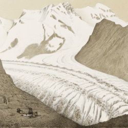
Agassiz, L.
Untersuchungen über die Gletscher. [Complete text and atlas].
Solothurn, Jent & Gassmann, 1840-1841; Neuchatel, H. Nicolet, 1840. Text: 8vo (21.5 x 14.2 cm). xii, 326, [i] pp. 19th-century pebbled half cloth over marbled boards. Spine with gilt ornamental bands and title. Greenish endpapers. Subtly marbled edges. Atlas: Oblong folio (29.7 x 44.0 cm). 18 lithographed plates of which 14 with printed overlays (as intended). Contemporary green quarter calf over green boards. Spine with gilt bands. Original pictorial title mounted on front board.
Read more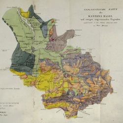
Merian, P.
Uebersicht der Beschaffenheit der Gebirgsbildungen in den Umgebungen von Basel, mit besondrer Hinsicht auf das Juragebirge im Allgemeinen.
Basel, Schweighauser, 1821. 8vo (20.2 x 12.1 cm). xii, 156 pp; one large, folded hand-coloured map and one hand-coloured plate. Original printed wrappers.
Read more
Meyer, C. E. H. von
Ueber den Nager von Waltsch in Böhmen [AND] Physichthys Höninghausi aus dem Uebergangkalke der Eifel [AND] Schildkröte und Vogel aus dem Fischschiefer von Glarus [AND] Helochelys Danubia, aus dem Grünsande von Kelheim in Bayern [AND] Trachyteuthis ensiformisaus dem lithographischen Schiefer in Bayern.
Cassel [Kassel], Palaeontographica, 1855. Six papers in one. 4to (31.0 x 23.2 cm). 35 [5; 4; 12; 10; 4] pp.; six engraved plates [1; 1; 2 (one shared); 2 (one shared); 1], the two turtle and one cephalopod plate double-sized. Contemporary wrappers with the title added in script.
Read more
Unger, F.
Ueber den Einfluss des Bodens auf die Vertheilung der Gewächse nachgewissen in der Vegetation des nordöstlichen Tirols.
Wien, Rohrmann und Schweigerd, 1836. 8vo (21.4 x 13.5 cm). xxiv, 367 pp.; one hand-coloured engraved plate of Kitzbühl, one large, folded, hand-coloured geological-geographical map, one large, folded hand-coloured sheet with geological profile, five folded charts with meteorological observations (four) and botanical observations (one), many tables in the text. Contemporary quarter calf over marbled boards. Spine with gilt lines, vignettes, and title. Marbled endpapers; speckled edges.
Read more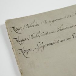
Meyer, H. von
Ueber den Archegosaurus der Steinkohlenformation [AND] Fische, Echinodermen und andere Versteinerungen aus dem Muschelkalk Oberschlesiens [AND] Sphyraenodus aus dem Tertiärsande von Flonheim.
Cassel, Palaeontographica, 1849. 4to (29.2 x 23.0 cm). 76 [5; 68; 3] pp.; four engraved plates. Contemporary wrappers with the titles added in a neat old hand.
Read more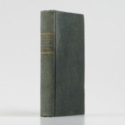
Catullo, T. A.
Trattato sopra la costituzione geognostico-fisica dei terreni alluviani o postdiluviani delle provincie Venete.
Padova, Cartallier e Sicca, 1838. 8vo (21.2 x 13.3 cm). Title page with engraved vignette, [iv], 512 pp.; several tables in the text. Mid-19th-century pebbled cloth. Gilt title on the spine.
Read more
Hochstetter, F. von and A. Petermann.
The geology of New Zealand: in explanation of the geographical and topographical atlas of New Zealand by Dr. F. Von Hochstetter and Dr. A. Petermann, from the Scientific Publications of the Novara Expedition. Translated by C. F. Fischer. Also, lectures by Dr. F. Hochstetter delivered in New Zealand.
Auckland, T. Delattre, 1864. 8vo (21.0 x 13.6 cm). Title page, 113 pp. Original grained red cloth with gilt title on the front board.
Read more
Bonnard, A. H. De
Sur la constance des faits géognostiques, qui accompagnent le gisement du terrain d'Arkose à l'est du Plateau Central de la France.
Paris, Mme Huzard, 1828. 8vo (21.5 x 13.3 cm). 106 pp.; three folded engraved geological profiles. Contemporary polished half calf. Spine with five raised, gilt-bordered bands and gilt title on red morocco shield. Marbled flyleaves.
Read more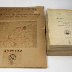
Willis, B. (ed.)
Research in China. In three volumes and atlas. 1(1). Descriptive topography and geology; 1(2). Petrography and zoology; 2. Systematic geology; 3. The Cambrian faunas of China. A report on Ordovician fossils collected in eastern Asia in 1903-04. A report on Upper Paleozoic fossils collected in China 1903-04; [4.] Geographical and geological maps. [Complete].
Washington, DC, The Carnegie Institution of Washington, 1907-1913. In five parts (four text and plate volumes, one atlas). 4to (29.8 x 24.0 cm). Text; 101 plates, including six chromolithographs of birds, and geological maps; folio atlas (52.7 x 45.0 cm) with 42 mostly coloured geological and topographical maps (some with explanatory text or figures). Original printed wrappers.
Read more
