Regional Earth Sciences - Geology
69 items found
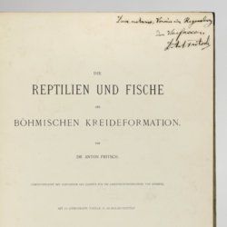
Fritsch, A. [J.]
Die Reptilien und Fische der böhmischen Kreideformation.
Prag, Verlag des Verfassers (Fr. Řivnáč), 1878. Large 4to (33.5 x 25.1 cm). [ii], 44, [ii] pp.; 66 text engravings; ten lithographed plates of which nine tinted, and two larger, folded. Original blind quarter linen over printed boards.
Read more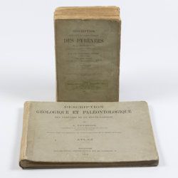
Leymerie, A. [F. G. A.]
Description géologique et paléontologique des Pyrenées de la Haute-Garonne accompagnée d'une carte topographique et géologique à l'echelle 1:200.000 et d'un Atlas...
Toulouse, Privat, 1878, 1881. In two volumes. Text (1881) 8vo (24.0 x 16.0 cm). Atlas (1878) oblong 4to (23.5 x 31.5 cm). 1,027 pp.; 51 lithographed plates of which 11 tinted or coloured (and of which 30 are on fossils), including a large folded transection of the Pyrenees, Haute Garonne, and the large coloured geological map (with 20 colours) mounted on linen. Original printed wrappers (text) and boards (atlas).
Read more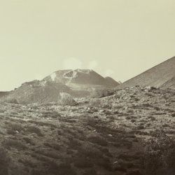
Silvestri, O.
Etna. Eruzione e terremoti del Maggio-Giugno 1879. Fotografie fatte per incarico del R. Governo Italiano sotto la direzione del Prof. Orazio Silvestri.
[Catania], A. T. Tagliarini, "1879" [1880]. Oblong folio, with 30 (of 33 or 34?) original albumen prints of slightly variable size, on average 17.5 x 32.0 cm (plates 1-22), or four times 19 x 24 cm (plates 23-24), all mounted on 24 (of 25?) very large printed boards, each 48.5 x 56.8 cm and with a gilt frame of 29.2 x 39.1 cm (plates 1-22), or four times 20.4 x 25.8 cm (plates 23-24) with printed captions mounted, and printed captions on the boards. In clamshell box of navy pebbled cloth over marbled boards (58.3 x 51.4 x 3.7 cm) with original printed labels on the front board recto and verso.
Read more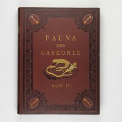
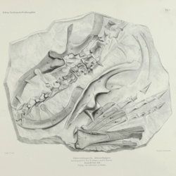
Fritsch, A.
Fauna der Gaskohle und der Kalksteine der Permformation Böhmens. Band I-IV. [Complete].
Prag, Selbstverlag and F. Řivnáč, 1879-1899 [1901?]. Four volumes in four. Folio (34.0 x 25.5 cm). 459 pp., lavishly illustrated with 167 mostly chromolithographed plates (several double-sized or larger, folded), and over 400 text engravings, of which some plate-sized. Volume I (1883): 182 pp., 48 plates (some larger, folded, a few plain), 160 text engravings; volume II (1889): 114 pp., 44 plates (several larger, folded; numbered 49-90, 80b, 81b), 79 text figures (numbered 117-188); vol. III (1895): 132 pp., 42 plates [several (much) larger; numbered 91-132], 122 text engravings (numbered 189-310); vol. IV (1901): 101 pp., full colour frontispiece, of a landscape with "Miriopoden"; 33 plates (numbered 133-165), 64 text engravings (numbered 311-394, and including phototypes of fossil animals and tracks, freshwater bivalves, and, e.g. the author at work). Original uniform brown cloth sumptuously embossed with black floral borders, and gilt vignettes depicting Permian amphibians, reptiles and fish. Marbled edges.
Read more
Rothpletz, A.
Ein geologischer Querschnitt durch die Ost-Alpen nebst Anhang über die sog. Glarner Doppelfalte.
Stuttgart, E. Schweizerbart (E. Koch), 1894. 8vo (22.4 x 15.4 cm). iv, 208 pp.; two full colour folded profiles of which one measuring 22.5 x 352.0 cm (!), 115 text illustrations. Contemporary half cloth over marbled boards. Gilt lines and two red morocco labels with gilt title on the spine. Edges speckled.
Read more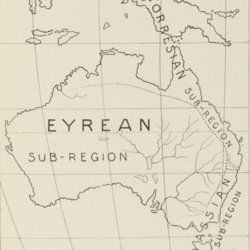
Spencer, [W.] B. (ed.)
Report on the work of the Horn Scientific Expedition to Central Australia. Part I. Introduction, narrative, summary of results, supplement to zoological report, map.
London, Dulau; Melbourne, Mullen and Slade, 1896. 4to (25.6 x 19.2cm). xviii, 220 pp.; 11 plates, seven text illustrations, one large, multi-folded map. Original azure buckram with gilt title on the spine.
Read more
Carez, L. [L. H.]
La géologie des Pyrénées Françaises.
Paris, Imprimerie Nationale, 1903-1909. In six volumes, including the supplement. Large 4to (29.5 x 22.6 cm). 3,908 [ix, 3,899] pp.; 39 mainly geological folded maps or profiles (six in full-colour), and heliogravures (photogravures), some with printed overlays. Uniform contemporary half calf over marbled boards. Spines with four raised bands and gilt title.
Read more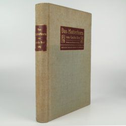
Rey, G.
Das Matterhorn. Vorwort von E. de Amicis with geologische Erläuterungen by V. Novarese.
Stuttgart and Leipzig, Deutsche Verlags-Anstalt, 1905. 4to (29.2 x 21.0 cm). xi, 258 pp.; 35 plates of which 14 are nicely tinted photographic plates after water-colours, mounted on black paper, all by Edoardo Rubino and 11 photographs (most by Vittorio Sella and a few by G. Rey) and ten photographic plates from drawings also by Edoardo Rubino. Furthermore there are 13 images of drawings in the text also by Edoardo Rubino [complete]. Original cloth with bevelled edges, gilt mounted title piece on front board and gilt-lettered spine label. Mottled olive endpapers. Top edge gilt.
Read more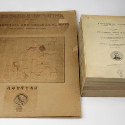
Willis, B. (ed.)
Research in China. In three volumes and atlas. 1(1). Descriptive topography and geology; 1(2). Petrography and zoology; 2. Systematic geology; 3. The Cambrian faunas of China. A report on Ordovician fossils collected in eastern Asia in 1903-04. A report on Upper Paleozoic fossils collected in China 1903-04; [4.] Geographical and geological maps. [Complete].
Washington, DC, The Carnegie Institution of Washington, 1907-1913. In five parts (four text and plate volumes, one atlas). 4to (29.8 x 24.0 cm). Text; 101 plates, including six chromolithographs of birds, and geological maps; folio atlas (52.7 x 45.0 cm) with 42 mostly coloured geological and topographical maps (some with explanatory text or figures). Original printed wrappers.
Read more
Granö, J. G.
Beiträge zur Kenntnis der Eiszeit in der Nordwestlichen Mongolei und einigen ihrer südsibirischen Grenzgebirge. Geomorphologische Studien aus den Jahren 1905, 1906, 1907 und 1909.
Helsingfors, J. Simelii [for the Geographical Society of Finland], 1910. Large 8vo (24.9 x 16.5 cm). iv, 230 pp.; seven large, folded coloured maps, 19 photographic plates. Later quarter calf over pictorial boards.
Read more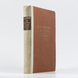
Schmidt, R. R.
Die diluviale Vorzeit Deutschlands.
Stuttgart, E. Schweizerbart (Nägele und Dr. Sproesser), 1912. Very large 4to (35.5 x 30.0 cm). xiii, 283 pp.; 47 engraved or heliogravure plates with explanatory text leaves, loose in rear pocket. Original quarter vellum over cloth boards. Gilt title on front board; gilt-lettered morocco label on the spine.
Read more
Lacroix, A.
Mineralogie de Madagascar. Tomes I-II-III. [Complete].
Paris, Augustin Challamel, 1922-1923. Three parts in three. 4to (27.1 x 21.3 cm). 1,799 [xvi, 624; vii, 694; viii, 450] pp.; 540 text illustrations [504; 11; 25], 64 plates [27; 29; 8], one tinted double-sized geographical map of Madagascar, Mayotte, and the Comores (in volume I), one very large, multi-folded full colour geological map (in volume III). Uniform contemporary red buckram. Spines with gilt title. Marbled endpapers. Speckled edges.
Read more
Canavari, M. (ed.)
Palaeontologia della Somalia. Fossili raccolti dalle Missioni Stefanini-Paoli (1913) e Stefanini-Puccioni (1924) e da altri.
Pisa, Museo Geologico della R. Università di Pisa, 1931-1939 [REPRINT Bologna, Forni, 1969]. In five volumes. 4to (31.2 x 21.4 cm). 1,115 pp. [216; 192; 301; 89; 270, 47]; 111 plates [17; 24; 26; 12; 27, 5]; numerous text illustrations. Original uniform printed wrappers.
Read more
Tokunaga, S. et al.
Report of the First Scientific Expedition to Manchoukuo. Under the leadership of Shigeyasu Tokunaka. June - October 1933. Section II [Geology]. Part I-IV. [Complete].
Tokyo, Asahi, 1934-1939. Four volumes in four. 4to (26.0 x 19.0 cm). Ca. 700 pp. with 124 plates and three folding coloured maps. Original uniform printed stiff wrappers.
Read more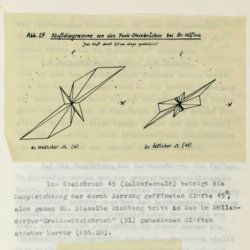
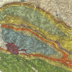
Tollmann, A.
Das Neogen am Südwestrand des Leithagebirges zwischen Eisenstadt und Hornstein. Dissertation zur Erlangung des Doktorgrades an der Philosophischen Fakultät der Universität Wien.
Wien, [not published], 1953. Small folio (29.8 x 21.0 cm). 226 pp.; 28 text figures (tipped in), three large folded maps (one hand-coloured), five folded tables and graphs. Black half cloth. Hand-written label on the spine.
Read more
Allemann, F.
Geologische Karte Fürstentum Liechtenstein.
[Vaduz], Regierung des Fürstentums Liechtenstein, 1953. Large (102.0 x 67.0 cm), folded map, consisting of 25 rectangular sheets in full colour, mounted on linen. Handwritten and stamped label on the front-facing part of the linen map verso.
Read more