Earth Sciences - Geology
155 items found
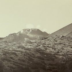
Silvestri, O.
Etna. Eruzione e terremoti del Maggio-Giugno 1879. Fotografie fatte per incarico del R. Governo Italiano sotto la direzione del Prof. Orazio Silvestri.
[Catania], A. T. Tagliarini, "1879" [1880]. Oblong folio, with 30 (of 33 or 34?) original albumen prints of slightly variable size, on average 17.5 x 32.0 cm (plates 1-22), or four times 19 x 24 cm (plates 23-24), all mounted on 24 (of 25?) very large printed boards, each 48.5 x 56.8 cm and with a gilt frame of 29.2 x 39.1 cm (plates 1-22), or four times 20.4 x 25.8 cm (plates 23-24) with printed captions mounted, and printed captions on the boards. In clamshell box of navy pebbled cloth over marbled boards (58.3 x 51.4 x 3.7 cm) with original printed labels on the front board recto and verso.
Read more
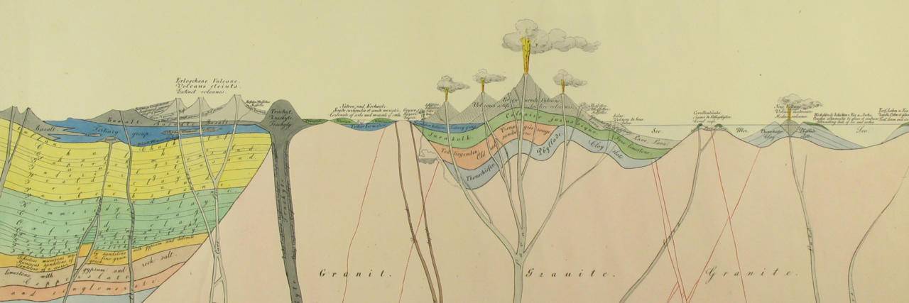
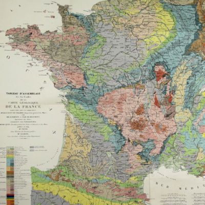
Dufrenoy, [O. P. A.] and [J. B. A. L. L.] Élie de Beaumont
Explication de la carte géologique de la France. Volumes I-IV (text and atlas), and two maps. [Complete].
Paris, Imprimerie Royale, Imprimerie Nationale, 1841-1879. Four volumes in seven, and a large map in six folded sheets, each ca. 70 x 205 cm (including borders) with linen covers. Large 4to (four text volumes; ca. 27.5 x 21.0 cm); folio (two atlas volumes, 26.8 x 35.7 cm). Tome premier: Paris, Imprimerie Royale, 1841. Large 4to. xxii, 825 pp., 71 text engravings (mainly profiles); Tome deuxième: Paris, Imprimerie Nationale, 1848. Large 4to. xii, 813 pp., 105 text engravings (mainly views and profiles), one large, folded chromolithographed geological map (finished by hand) of France (printed surface: 57 x 54 cm, and consisting of 15 smaller sections, mounted on linen and folded) bound in the rear; Tome troisième. Première partie (by Dufrénoy): Paris, Imprimerie Nationale, 1873. Large 4to. viii, 231 pp., 18 text engravings (mainly profiles). Printed wrappers. Tome quatrième. Seconde partie. Végétaux fossiles du terrain houiller (by Zeiller): Paris, Imprimerie Nationale, 1879. Large 4to. 185 pp. Printed wrappers; Tome quatrième. Atlas (in two volumes). Première partie. Fossiles principaux des terrains (by É. Bayle). Seconde partie. Végétaux fossiles du terrain houiller (by Zeiller): Paris, Imprimerie Nationale, 1878. Folio. Title page, half title to first part. 86 lithographed plates with explanatory text leaves, numbered I-LXXXVI; 90 lithographed plates with explanatory text leaves, numbered LXXXVII-CLXXVI (the last 16 on plants), for a total of 176 plates. Volumes I, II, and IV plate volumes in near uniform contemporary dark-green pebbled morocco over marbled boards. Spines with five gilt-stippled bands, and gilt title. Marbled endpapers. The text volumes with top edge gilt, atlases with marbled top edges. Text volumes III and IV in original printed wrappers. The large chromolithographed map in six sheets (approximately 218 x 223 cm) is contained in a contemporary, book-like crimson box with gilt-lettered spine, with raised bands and patterned paper sides.
Read more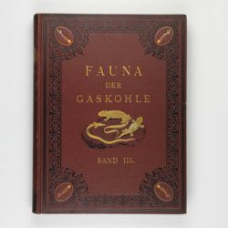
Fritsch, A.
Fauna der Gaskohle und der Kalksteine der Permformation Böhmens. Band I-IV. [Complete].
Prag, Selbstverlag and F. Řivnáč, 1879-1899 [1901?]. Four volumes in four. Folio (34.0 x 25.5 cm). 459 pp., lavishly illustrated with 167 mostly chromolithographed plates (several double-sized or larger, folded), and over 400 text engravings, of which some plate-sized. Volume I (1883): 182 pp., 48 plates (some larger, folded, a few plain), 160 text engravings; volume II (1889): 114 pp., 44 plates (several larger, folded; numbered 49-90, 80b, 81b), 79 text figures (numbered 117-188); vol. III (1895): 132 pp., 42 plates [several (much) larger; numbered 91-132], 122 text engravings (numbered 189-310); vol. IV (1901): 101 pp., full colour frontispiece, of a landscape with "Miriopoden"; 33 plates (numbered 133-165), 64 text engravings (numbered 311-394, and including phototypes of fossil animals and tracks, freshwater bivalves, and, e.g. the author at work). Original uniform brown cloth sumptuously embossed with black floral borders, and gilt vignettes depicting Permian amphibians, reptiles and fish. Marbled edges.
Read more
Lippi, C.
Fu il fuoco, o l'acqua che sotterro Pompei ed Ercolano? Scoperta geologico-istorica, fatta dall'autore il di 14 e 26 Ottobre 1810, e da lui scritta nelle lingue latina, inglese, francese, italiana, tedesca, e spagnuola in due lettere. Seguite dalle scritture pro et contra, presentate all' Accademia di scienze di Napoli, per di lei ordine; e dalle decisioni di questa Società, relative al' argomento. Prima edizione Italiana.
Napoli, Domenico Sangiacomo, 1816. 8vo (18.9 x 11.4 cm). [iv], 384 pp.; one folded plate. Contemporary half calf over marbled boards. Rich gilt spine. Edges yellow.
Read more
[Geological map]
Geognostische Karte von Württemberg [AND] Begleitworte zur geognostischen Specialkarte von Württemberg.
Stuttgart, Das Königliches Statistisch-topographisches Bureau, Kohlhammer, Kleeblatt, 1863-1892. With 54 chromolithographed folded geological maps, all mounted on linen, numbered 1-48, 50-55, in two original, uniform burgundy boxes with gilt title on the lid. [AND] the "Begleitworte" 34 parts in one. Large 8vo (25.7 x 19.5 cm). Stuttgart, Königlich Statistischen Landesambt, (1865-1892). ca. 1,000 pp., and five hand-coloured wood-engraved or lithographed maps or geological profiles, and four wood-engraved plates. Contemporary half cloth over marbled boards. Spine with gilt title, ornaments, and the Württemberg coat-of-arms; patterned endpapers, and marbled edges.
Read more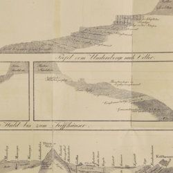
Oeynhausen, C. von and H. von Dechen and H. von La Roche
Geognostische Umrisse der Rheinländer zwischen Basel und Mainz mit besonderer Rücksicht auf das Vorkommen des Steinsalzes, nach Beobachtungen entworfen auf einer Reise im Jahre 1823 gesammelt.
Essen, G. Bädeker, 1825. Two volumes in one. 8vo (19.8 x 12.0 cm). 782 pp.; one folding lithographed plate with several geological profiles. Contemporary half cloth over marbled boards. Paper label with the title in an old hand on the spine. Original endpapers.
Read more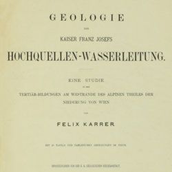
Karrer, F.
Geologie der Kaiser Franz Josefs Hochquellen-Wasserleitung. Eine Studie in den Tertiär-Bildungen am Westrande des alpinen Theiles der Niederung von Wien.
Wien, Hölder, 1877. Large 4to (33.5 x 25.5 cm). xiii, 420 pp.; 96 text engravings, 20 folded profiles, maps and lithographed plates, mostly coloured and several very large (size up to 32 x 100 cm), seven folded charts and tables. Later half cloth with paper label on the spine.
Read more

Allemann, F.
Geologische Karte Fürstentum Liechtenstein.
[Vaduz], Regierung des Fürstentums Liechtenstein, 1953. Large (102.0 x 67.0 cm), folded map, consisting of 25 rectangular sheets in full colour, mounted on linen. Handwritten and stamped label on the front-facing part of the linen map verso.
Read more
Arnold, F.
Halenza's neuestes Rhein-Panorama von Mainz bis Cöln. Einziges, durch die Berliner und Frankfurter Künstler gefässtes Urtheil, anerkanntes Kustwerk. Panorama du Rhin depuis Mayence jusq'à Cologne. Panorama of the Rhine, from Mentz to Cologne. [Complete with the rare text volume].
Mainz, J. Halenza, [1880]. Two parts in two. 8vo (text: 26.4 x 16.2 cm). Title page, 24 pp. (in English). Panorama: One folding lithographed view by F. Foltz (27 x 230 cm). Contained in original printed boards with the German title on one board, and the French/English titles on the other.
Read more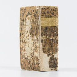
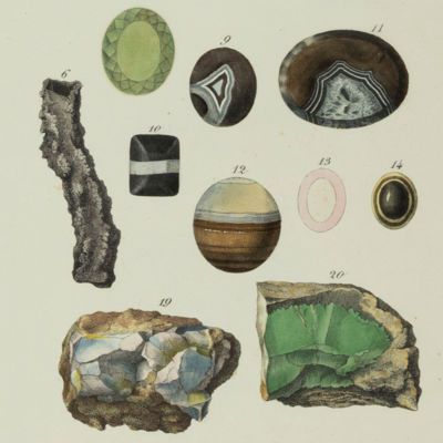
Widenmann, J. F. W.
Handbuch des oryktognostischen Theils der Mineralogie.
Leipzig, Siegfried Lebrecht Crusius, 1794. Thick 8vo (19.6 x 12.2 x 6.0 cm). xiv, [vi], 1,040, [4], [xv] pp.; two folded engravings, one with 74 different colours. Contemporary marbled boards. Spine with gilt lines and morocco label with gilt title. All edges red.
Read more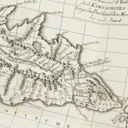
Lesseps, [J. B. B.] de
Herrn von Lesseps Gefährten des Grafen de la Perouse Reise durch Kamtschatka und Sibirien nach Frankreich. Aus dem Französischen übersetzt. Mit Anmerkungen von Johann Reinhold Forster.
Berlin, Voss, 1791. 8vo (22.4 x 14.5 cm). xxviii, 302 [303-544] pp.; two engraved, folded maps, one folded table. Original blind boards.
Read more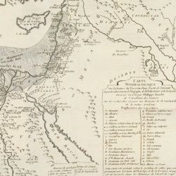
Guettard, J. E.
Histoire de l'Academie Royale des sciences, Année MDCCLI [1751], avec les mémoires de mathématique & de physique, pour la même année. Tirés des registres de cette académie.
Paris, l'Imprimerie Royale, 1755. 4to (25.1 x 18.9 cm). 738 [202, 536] pp.; 23 mostly large, folded plates. Contemporary full tree-calf. Spine with five raised bands, gilt title and gilt vignettes. Marbled endpapers. Red edges.
Read more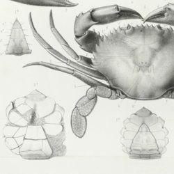
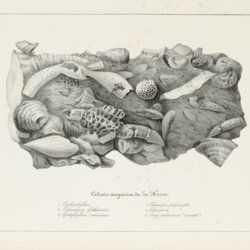
Milne-Edwards, A.
Histoire des crustacés podophthalmaires fossiles.
Paris, Martinet, 1861. 4to (26.5 x 21.5 cm). 222 pp.; one folding table, 16 engraved or lithographed plates (three larger, folded). Later marbled boards with printed label on the front board. Original printed wrappers bound in.
Read more
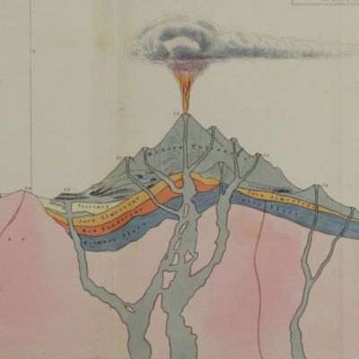
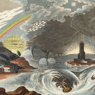
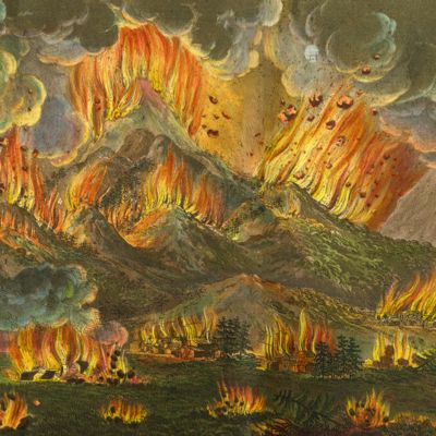
Serao, F.
Histoire du Mont Vésuve, avec l'explication des phenomenes qui ont coûtume d'accompagner les embrasements de cette montagne. Le tout traduit de l'Italien de l'Académie des Sciences de Naples. Par M. Duperron de Castera. Dédiée a monseigneur le Dauphin.
Paris, Huart, 1741. Small 8vo (16.6 x 9.5 cm). xxiii, 361, [iii] pp.; three large folded plates, one very large folded table. Contemporary full calf. Spine with five raised bands. Compartments with rich gilt floral patterns and red morocco label with gilt title. Marbled endpapers. Edges red.
Read more
Torre, G. M. Della
Histoire et phénomènes du Vésuve. Exposés par le Pere Dom Jean-Marie Della-Torre, clerc régulier sommasque, garde bde la bibliothéque & du cabinet du roi des Deux-Siciles, & correspondant de l'Académie Royale des Sciences de Paris. Traduction de l'Italien par M. l'abbé Péton.
Paris, Jean-Thomas Hérissant, 1760. 12mo (16.3 x 9.2 cm). xxiv, 399 pp., one large folded map of Mount Vesuvius, the Bay of Naples and surroundings, and five folded plates with panoramas and other views of the volcano, caldera, etc. Contemporary full mottled calf. Spine with five raised bands. Compartments with gilt floral vignettes and small red morocco label with gilt title. Marbled endpapers, marbled edges.
Read more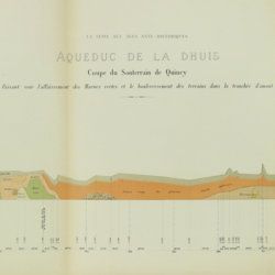
Belgrand, [M. F.] E.
Histoire générale de Paris. La Seine. I. Le bassin Parisien aux âges antéhistoriques.
Paris, Imprimerie Impériale, 1869. In three parts (Texte, Atlas de Paléontologie, and Planches de Géologie et de Conchyliologie). Large 4to and folio (33.8 x 23.9 cm). Texte: cvi, 289 pp., four double-sized coloured maps, 36 engraved text figures, five tissue-guarded plates (four profiles and one with stone age axes); Atlas: 82 [46, a-d] pp.; seven text engravings, 86 plates [1-79, 29bis, 48bis, 53bis, 59bis, 59ter, 62bis, 62ter, 78bis) being tissue guarded heliogravures of mammalian bones, including human skulls, etc., and stone age tools. Géologie and Conchyliologie, 32 pp. Three lithographed plates of shells, three very large folded, coloured geological profiles (numbered 5-7, being a suite to the maps in the text part). All in original green, printed boards or wrappers. Not in Nissen, ZBI.
Read more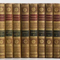
Sonnini, C. S.
Histoire naturelle générale et particulière, par Leclerc de Buffon; nouvelle edition accompagnée de notes, et dans laquelle les supplémens sont insérés dans le premier texte, à la place qui leur convient. Ouvrage formant un cours complet d'histoire naturelle; redige par C. S. Sonnini, membre de plusieurs sociétés savantes. Tomes Mineraux 1-16. [Théorie de la terre 1-3; Epoques de la nature; Introduction a l'histoire des minéraux 1-3; Mineraux 1-9].
Paris, Dufart, An VIII (1798) - X (1800). 16 parts in 16. 8vo (19.5 x 12.2 cm). Engraved frontispiece, 7156 pp.; nine engraved plates, four folded maps. Contemporary uniform full tree calf. Boards with gilt ornamented borders and gilt dentelles. Rich gilt spines, gilt titles on two (red and black) morocco labels, marbled flyleaves, all edges speckled red on yellow.
Read more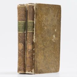
Le Goux de Flaix, A. [Legoux]
Historisch-geographisch politischer Versuch über Ostindien nebst der Schilderung von dessen Handel nach Le Goux de Flaix. Mit Noten, Anmerkungen und einer Vorrede von E. A. W. v. Z[immermann].
Leipzig, Heinrich Gräff, 1810. Two volumes in two. 8vo (17.5 x 10.7 cm). 892 [I: viii, 444; II: iv, 436] pp.; one folded engraving of the Jagannath temple. Contemporary uniform tree calf resembling paper boards with ruled borders, olive and brown gilt-lettered morocco labels on spines.
Read more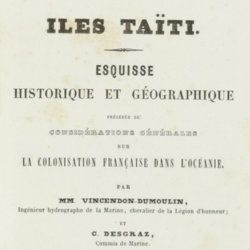
Vincendon-Dumoulin, [C. A.] and C. [L. F.] Desgraz
Iles Taïti. Esquisse historique et géographique précédée de considérations générales sur la colonisation française dans l'Océanie. Première Partie - Deuxième Partie. [Complete].
Paris, Arthus Bertrand, 1844. In two parts. 8vo (21.5 x 14.1 cm). Half-titles, title pages, 1056 pp. (pagination continuous); two large, engraved maps. Original uniform, printed wrappers.
Read more
