Earth Sciences - Geology
153 items found

Titsingh, [I.]
Mémoires et anecdotes sur la dynastie régnante des djogouns, souverains du Japon, avec la description des fêtes et cérémonies observées aux différentes epoques de l'année a la cour de ces princes, et un appendice contenant des détails sur la poésie des Japonais, leur manière de diviser l'année, etc; ouvrage orné de planches gravées et coloriées, tiré des originaux Japonais par M. Titsingh; publié avec les notes et éclaircissemens par M. Abel Rémusat.
Paris, A. Nepveu, 1820. 8vo (19.3 x 12.0 cm). xxviii, 302 pp.; one hand-coloured folded frontispiece, one engraved folded table, five hand-coloured folded plates. Contemporary full tree calf. Spine rich gilt including empire vignettes and a red morocco label with gilt title. Marbled endpapers. Edges speckled.
Read more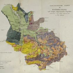
Merian, P.
Uebersicht der Beschaffenheit der Gebirgsbildungen in den Umgebungen von Basel, mit besondrer Hinsicht auf das Juragebirge im Allgemeinen.
Basel, Schweighauser, 1821. 8vo (20.2 x 12.1 cm). xii, 156 pp; one large, folded hand-coloured map and one hand-coloured plate. Original printed wrappers.
Read more
Cuvier, G. [L. C. F. D.] and A. Brongniart
Description géologique des environs de Paris, par MM. G. Cuvier et Alex. Brongniart. Nouvelle édition, dans laquelle on a inséré la descrition d'un grand nombre de lieux de l'Allemagne, de la Suisse, de l'Italie, etc., qui présentent des terrains analogues a ceux du Bassin de Paris. Avec 2 cartes et 16 planches représentant les coupes de ces terrains et beaucoup des coquilles fossiles qu'ils renferment, et une table alphabétique de tous les lieux décrits ou seulement cités.
Paris, G. Dufour et E. d'Ocagne, 1822. 4to (29.3 x 22.2 cm). ix, 428 pp.; one brightly hand-coloured geological map of the surroundings of Paris, and 17 lithographed plates, including one hand-coloured geological map of the basins of London and Paris. Contemporary half calf over marbled boards. Spine with five raised, gilt-ornamented bands; compartments rich gilt, and with two morocco labels (red and blue) with gilt title.
Read more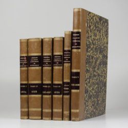
[Various geologists and palaeontologists]
Mémoires de la Société Linnéenne de Normandie. Volumes I-V. [IINCLUDING Société Linnéenne de Calvados].
Caen, Société Linnéenne de Normandie, 1824-1835. Five volumes in six. 8vo (volumes I-IV, 21.0 x 13.2 cm), 4to (volume V, 27.6 x 22.0 cm), and oblong folio (atlas to volumes II-IV, 22.5 x 31.0 cm). Title pages; 15 lithographed (partly folded) plates in volume I, one hand-coloured geological map, 39 lithographed plates in the atlas volume, mainly depicting lichens by Delise, and geological maps (11 hand-coloured). Uniform later half calf over marbled boards. Spines with gilt title.
Read more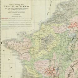
Beche, H. de la
A selection of the Geological Memoirs, contained in the Annales des Mines, together with a synoptical table of equivalent formations and Brongniart's table of the classification of mixed rocks. Translated with notes by H. T. de la Beche, Esq.
London, William Phillips, 1824. 8vo (21.1 x 13.3 cm). xxii, 335 pp.; one hand-coloured folded geological map of France and the Netherlands including a great part of Germany, the Alps and northern Italy, by J. d'Omalius d'Halloy (numbered plate 11 [not II]) and two further hand-coloured geological maps or profiles (numbered I-II), eight folded lithographed plates (numbered III-X), including a very fine view of the coalmine at Treuil near St. Etienne, one folding table. Contemporary half calf over marbled boards. Spine with gilt lines and title. Edges speckled red.
Read more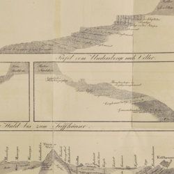
Oeynhausen, C. von and H. von Dechen and H. von La Roche
Geognostische Umrisse der Rheinländer zwischen Basel und Mainz mit besonderer Rücksicht auf das Vorkommen des Steinsalzes, nach Beobachtungen entworfen auf einer Reise im Jahre 1823 gesammelt.
Essen, G. Bädeker, 1825. Two volumes in one. 8vo (19.8 x 12.0 cm). 782 pp.; one folding lithographed plate with several geological profiles. Contemporary half cloth over marbled boards. Paper label with the title in an old hand on the spine. Original endpapers.
Read more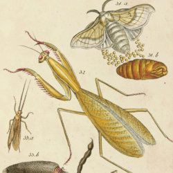
Sturm, J.
Kupfersammlung zu Schuberts und jeder andern Naturgeschichte brauchbar. In 12 Blättern, nach der Natur gezeichnet, gestochen und gemahlt.
Nürnberg, privately published, (n.d., but circa 1825). 8vo (20.1 x 12.0 cm). pp. v-viii; 12 hand-coloured engraved plates. Contemporary blind grey/black mottled paper covered boards. Original printed wrappers bound in.
Read more
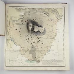
Devèze de Chabrol, J. S. and J. B. Bouillet
Essai géologique et minéralogique sur les environs d'Issoire, département du Puy-de-Dôme, et principalement sur la Montagne de Boulade.
Clermont-Ferrand, Thibaud-Landriot, 1827. Folio (41.0 x 26.2 cm). xii, 104 pp.;hand-coloured lithographed geological map and hand-coloured profile, and 30 lithographed plates depicting vertebrates and several tables, including one very large, folded in the text. Contemporary half morocco over marbled boards. Spine with gilt lines and title. Marbled endpapers; speckled edges.
Read more
Bonnard, A. H. De
Sur la constance des faits géognostiques, qui accompagnent le gisement du terrain d'Arkose à l'est du Plateau Central de la France.
Paris, Mme Huzard, 1828. 8vo (21.5 x 13.3 cm). 106 pp.; three folded engraved geological profiles. Contemporary polished half calf. Spine with five raised, gilt-bordered bands and gilt title on red morocco shield. Marbled flyleaves.
Read more
Duppa, R.
Travels on the continent, Sicily and the Lipari Islands. Second edition.
London, Longman, Rees, Orme, and Co., 1829. Large 8vo (26.8 x 17.2 cm). x, 494, [ii] pp.; 21 fine engraved plates, and 34 text engravings. Contemporary grained half morocco over marbled boards. Spine with five raised, stipple-gilted bands; compartments with gilt vignettes and a brown morocco label with gilt title.
Read more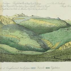
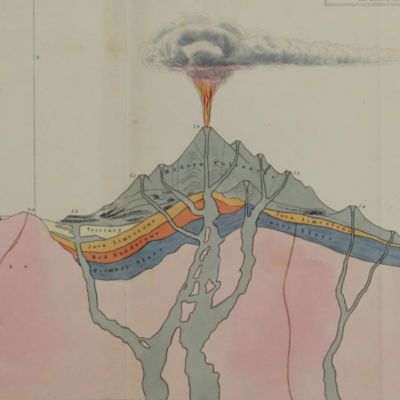
Lecoq, H. and J. B. Bouillet
Coup d'oeil sur la structure géologique et minéralogique du groupe des Monts Dores, accompagné de la description et des échantillons des substances minérales qui le composent.
Paris, Levrault and Clermont-Ferrand, Bouillet, Thibaud-Landriot, 1830. 8vo (20.0 x 13.1 cm). 48 pp.; five handcoloured lithographed plates (two much larger, folded) of geological views and profiles of the volcanological region of Puy-de-Dôme. Later red quarter calf over marbled boards. Gilt title on the spine. Marbled endpapers. Speckled edges.
Read more
[Various authors]
Annales des Mines. Series III-VI. Atlases.
Paris, Ecole de Mines, 1832-1866. Two series in four. Oblong folio (40.5 x 22.0 cm) with 758 (of 759? see below) engraved and lithographed plates and maps, of which 29 are hand-coloured geological maps or profiles. Contemporary uniform red cloth. Gilt titles on the spines and front boards. Marbled endpapers.
Read more
Passy, A. [F.]
Description géologique du département de la Seine-Inférieure. [Text and Atlas].
Rouen, Nicétas Periaux, 1832. Two parts [text and atlas] in one. 4to (26.7 x 21.3 cm). 402 pp. [xvi, 371; 15]; 20 engraved plates (several double-sized), of which 15 in original hand-colouring. Contemporary quarter morocco over marbled boards; spine with gilt title. Marbled endpapers.
Read more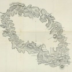
Rose, G.
Eléments de cristallographie.
Paris, Hachette et Firmin Didot, 1834. 8vo (19.9 x 12.7 cm). 270 pp.; title page (to IIe partie - planches), 12 pp.; 10 double-sized engraved plates with 121 figures, numbered 1-108 (plates I-IX), and 1-13 (plate X). Contemporary half calf over marbled boards. Spine with gilt lines and title. Marbled endpapers.
Read more
Lecoq, H.
[Auvergne] Itinéraire de Clermont au Puy de Dome, ou description de cette montagne et de la Vallée de Royat et Fontanat; seconde edition. [AND] Two other papers on the geology of Auvergne, by A. C. P. F. Von Lasaulx, and by J. B. Bouillet, bound in.
Paris, J. B. Baillière, 1836. 8vo (21.2 x 13.3 cm). vi, 102 pp. Early 20th century half morocco over marbled boards. Spine with five raised bands and gilt title. Marbled endpapers.
Read more
Unger, F.
Ueber den Einfluss des Bodens auf die Vertheilung der Gewächse nachgewissen in der Vegetation des nordöstlichen Tirols.
Wien, Rohrmann und Schweigerd, 1836. 8vo (21.4 x 13.5 cm). xxiv, 367 pp.; one hand-coloured engraved plate of Kitzbühl, one large, folded, hand-coloured geological-geographical map, one large, folded hand-coloured sheet with geological profile, five folded charts with meteorological observations (four) and botanical observations (one), many tables in the text. Contemporary quarter calf over marbled boards. Spine with gilt lines, vignettes, and title. Marbled endpapers; speckled edges.
Read more
Robert, E. [Gaimard]
Voyage en Islande et au Groënland executé pendant les années 1835 et 1836 sur la corvette La Recherche commandée par M. Tréhouart Lieutenant de Vaisseau dans le but de découvrir les traces de La Lilloise. Publié par ordre du Roi sous la direction de M. Paul Gaimard président de la Commission Scientifique d'Islande et de Groënland. Minéralogie et géologie.
Paris, Arthus Bertrand, 1838-1840. Two parts in one. Large 8vo (22.7 x 15.1 cm). Title page (to the text, dated 1840), xi, 469 pp.; second title page (to the atlas, dated 1838), [ii] pp., 36 lithographed plates. Contemporary quarter morocco over marbled boards. Spine rich gilt. Marbled endpapers. Speckled edges.
Read more
Catullo, T. A.
Trattato sopra la costituzione geognostico-fisica dei terreni alluviani o postdiluviani delle provincie Venete.
Padova, Cartallier e Sicca, 1838. 8vo (21.2 x 13.3 cm). Title page with engraved vignette, [iv], 512 pp.; several tables in the text. Mid-19th-century pebbled cloth. Gilt title on the spine.
Read more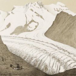
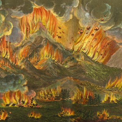
Agassiz, L.
Untersuchungen über die Gletscher. [Complete text and atlas].
Solothurn, Jent & Gassmann, 1840-1841; Neuchatel, H. Nicolet, 1840. Text: 8vo (21.5 x 14.2 cm). xii, 326, [i] pp. 19th-century pebbled half cloth over marbled boards. Spine with gilt ornamental bands and title. Greenish endpapers. Subtly marbled edges. Atlas: Oblong folio (29.7 x 44.0 cm). 18 lithographed plates of which 14 with printed overlays (as intended). Contemporary green quarter calf over green boards. Spine with gilt bands. Original pictorial title mounted on front board.
Read more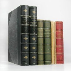
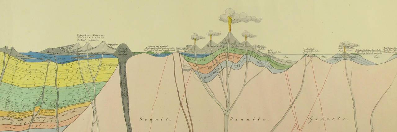
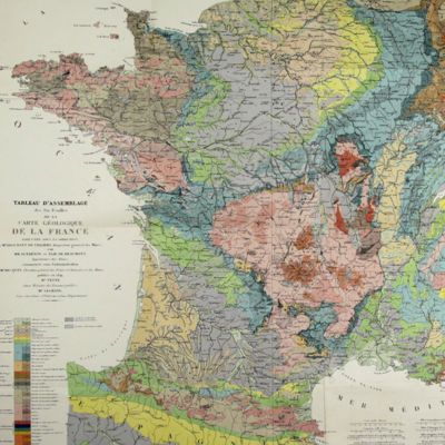
Dufrenoy, [O. P. A.] and [J. B. A. L. L.] Élie de Beaumont
Explication de la carte géologique de la France. Volumes I-IV (text and atlas), and two maps. [Complete].
Paris, Imprimerie Royale, Imprimerie Nationale, 1841-1879. Four volumes in seven, and a large map in six folded sheets, each ca. 70 x 205 cm (including borders) with linen covers. Large 4to (four text volumes; ca. 27.5 x 21.0 cm); folio (two atlas volumes, 26.8 x 35.7 cm). Tome premier: Paris, Imprimerie Royale, 1841. Large 4to. xxii, 825 pp., 71 text engravings (mainly profiles); Tome deuxième: Paris, Imprimerie Nationale, 1848. Large 4to. xii, 813 pp., 105 text engravings (mainly views and profiles), one large, folded chromolithographed geological map (finished by hand) of France (printed surface: 57 x 54 cm, and consisting of 15 smaller sections, mounted on linen and folded) bound in the rear; Tome troisième. Première partie (by Dufrénoy): Paris, Imprimerie Nationale, 1873. Large 4to. viii, 231 pp., 18 text engravings (mainly profiles). Printed wrappers. Tome quatrième. Seconde partie. Végétaux fossiles du terrain houiller (by Zeiller): Paris, Imprimerie Nationale, 1879. Large 4to. 185 pp. Printed wrappers; Tome quatrième. Atlas (in two volumes). Première partie. Fossiles principaux des terrains (by É. Bayle). Seconde partie. Végétaux fossiles du terrain houiller (by Zeiller): Paris, Imprimerie Nationale, 1878. Folio. Title page, half title to first part. 86 lithographed plates with explanatory text leaves, numbered I-LXXXVI; 90 lithographed plates with explanatory text leaves, numbered LXXXVII-CLXXVI (the last 16 on plants), for a total of 176 plates. Volumes I, II, and IV plate volumes in near uniform contemporary dark-green pebbled morocco over marbled boards. Spines with five gilt-stippled bands, and gilt title. Marbled endpapers. The text volumes with top edge gilt, atlases with marbled top edges. Text volumes III and IV in original printed wrappers. The large chromolithographed map in six sheets (approximately 218 x 223 cm) is contained in a contemporary, book-like crimson box with gilt-lettered spine, with raised bands and patterned paper sides.
Read more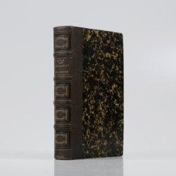
Sauvage, [F.] C. and [N.] A. Buvignier
Statistique minéralogique et géologique du département des Ardennes.
Mézières, Trecourt, 1842. 8vo (21.0 x 13.0 cm). xlv, 554 pp.; five lithographed plates. Contemporary half morocco over marbled boards. Spine with four raised, gilt-stippled bands; compartments with blind-stamped and gilt ornamental borders. Marbled endpapers.
Read more
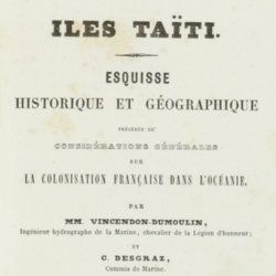
Vincendon-Dumoulin, [C. A.] and C. [L. F.] Desgraz
Iles Taïti. Esquisse historique et géographique précédée de considérations générales sur la colonisation française dans l'Océanie. Première Partie - Deuxième Partie. [Complete].
Paris, Arthus Bertrand, 1844. In two parts. 8vo (21.5 x 14.1 cm). Half-titles, title pages, 1056 pp. (pagination continuous); two large, engraved maps. Original uniform, printed wrappers.
Read more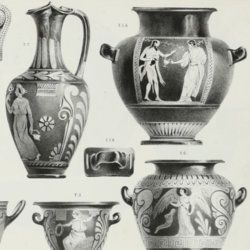
Brongniart, A.
Traité des arts céramiques ou des poteries, considérées dans leur histoire, leur pratique et leur théorie.
Paris, Béchet Jeune et Mathias, 1844. In three parts. 8vo (two text volumes, 20.7 x 13.5 cm), oblong 4to (atlas, 27.2 x 21.0 cm). xxvii, 592, 706 pp.; one engraved map, one engraved vignette facing preface, 109 woodcuts and oblong atlas with nine tables (three folded, pp. 1-29) and "explication des planches" (pp. 33-80) including an important list of porcelain signatures from all over Europe and 60 fine engraved plates. Contemporary uniform half calf over marbled boards. Spines with gilt lines and title. Marbled flyleaves.
Read more
Fuchs, W.
Die Venetianer Alpen. Ein Beitrag zur Kenntniss der Hochgebirgte, met einen geognostischen Karte und Gebirgteprofilen in achtzehn Tafeln.
Solothurn, Jent & Gassmann, 1844. Oblong folio (29.8 x 35.5 cm), [4], 60 pp.; 18 mostly hand-coloured engraved maps and plates. Text pages bordered with putti and goddesses. 19th century iridescent blue blind cloth.
Read more
Forbes, J. D.
Reisen in den Savoyer Alpen und in anderen Theilen der Penninen-Kette, nebst Beobachtungen über die Gletscher.
Stuttgart, Schweizerbart, 1845. 8vo (21.0 x 13.3 cm). xii, 386 pp.; seven lithographed plates (of which one hand-coloured) and two folded lithographed maps depicting the Chamonix Alps. Early 20th-century cloth with mounted title and backstrip from original printed boards and spine.
Read more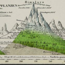
Humboldt F. [H.] A. von [Freiherr]
Kosmos. Entwurf einer physischen Weltbeschreibung. [Complete set of five text volumes and the authorized atlas by Bromme].
Stuttgart and Tübingen, J. C. Cotta, 1845-1862. Six volumes (text and atlas) in seven. 8vo (21.0 x 13.1 cm). 3546 pp. (1 [1845]: xvi, 394; 2 [1847]: 544; 3 [1850] 645; 4 [1858] 650; 5.1-5.2 [1862] 1-592; 593-1297). Atlas in two parts (descriptive text; maps) oblong 4to (28.1 x 34.1 cm); two title pages, [ii], 136 pp. (for a total of 3674 pp.); 42 lithographed and engraved maps of which 39 originally hand-coloured. Text volumes: Uniform brown, grained half morocco over pebbled boards. Spines with gilt ornamental bands and vignettes. Yellow endpapers. Mottled edges. Atlas volumes: uniform brown full cloth. Spines with gilt ornamental bands and title. Original printed wrapper bound in.
Read more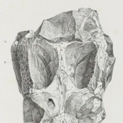
Terquem, O.
Observations sur le Lias du Département de la Moselle. Première Partie - Deuxième Partie. [Complete].
[Metz, Société d'Histoire naturelle du Département de la Moselle, 1847]. 8vo (22.3 x 14.3 cm). 60 pp., three engraved plates. Contemporary blind quarter cloth over paper-covered boards.
Read more
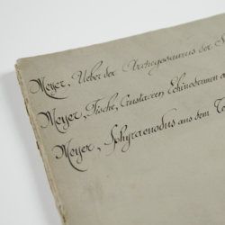
Meyer, H. von
Ueber den Archegosaurus der Steinkohlenformation [AND] Fische, Echinodermen und andere Versteinerungen aus dem Muschelkalk Oberschlesiens [AND] Sphyraenodus aus dem Tertiärsande von Flonheim.
Cassel, Palaeontographica, 1849. 4to (29.2 x 23.0 cm). 76 [5; 68; 3] pp.; four engraved plates. Contemporary wrappers with the titles added in a neat old hand.
Read more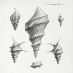
Orbigny, A. [C. V.] D. d'
Paléontologie Française. Description des mollusques et rayonnés fossiles. Terrains Jurassiques. II. Gasteropodes. Texte, Atlas. [Complete].
Paris, Victor Masson, 1850-1860. Two volumes in two. 8vo (21.3 x 13.2 cm [text]; 22.1 x 14.6 cm [atlas]). 623 pp.; 198 lithographed plates, numbered 235-431, 237bis. Contemporary uniform half morocco over marbled boards. Spines with four raised bands, gilt vignettes and title. Marbled endpapers.
Read more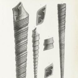
Orbigny, A. [C. V.] D. d'
Paléontologie Française. Description des mollusques et rayonnés fossiles. Terrains Jurassiques. II. Gasteropodes. Texte, Atlas. [Complete].
Paris, Victor Masson, 1850-1860. Two volumes in two. 8vo (22.2 x 14.1 cm [text]; 22.0 x 15.7 cm [atlas]). 623 pp.; 198 lithographed plates, numbered 235-431, 237bis. Contemporary uniform half morocco over marbled boards. Spines with four raised bands, gilt vignettes and title. Marbled endpapers.
Read more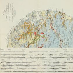
Wood, S. V.
A monograph of the Crag Mollusca, with descriptions of shells from the Upper Tertiaries of the British Isles. Part I. Univalves. Part II. Bivalves. Part III. Supplement to the Monograph of the Crag Mollusca, with descriptions of shells from the Upper Tertiaries of the east of England. Vol. III. Univalves and bivalves. [Part IV] Second supplement to the Crag Mollusca, comprising testacea from the Upper Tertiaries of the East of England. Univalves and bivalves. [Part V]. Third supplement to the Crag Mollusca, comprising testacea from the Upper Tertiaries of the east of England. [Complete].
London, The Palaeontographical Society, [1848-] 1850-1882. Five volumes in two. 4to (27.3 x 22.0 cm). 912 pp. [xii, 208; 342, 2; xxxi, 231; ii, 58; (ii), 24]; several text figures, 72 [21;31;13;6;1] lithographed plates with explanatory text leaves; one very large, multi-folded chart with profiles. Later uniform brown pebbled cloth with gilt title on the spines.
Read more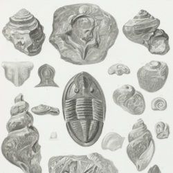
Owen, D. D.
Report of a geological survey of Wisconsin, Iowa and Minnesota; and incidentally of a portion of Nebraska territory. Made under instructions from the United States Treasury Department [AND] Illustrations to the geology report of Wisconsin, Iowa, and Minnesota.
Philadelphia, PA, Lippincott, Grambo & Co., 1852. Two parts in two. 4to (31.1 x 23.0 cm). Engraved frontispiece and title page, 639 pp. (first xxxviii in Roman numbers), numerous fine steel-engravings (text volume); title page, 27 (I-XV, IA-D, IIA-B, IIIA, VA-B, VIIIA, XIIA-B) fine lithographed plates with explanatory text leaves, and 21 mostly folding (all but two) and (partly) hand-coloured (all but two) geological maps, views, and profiles (atlas volume). Original near uniform blind-tooled cloth. Text volume spine with gilt title, plate volume with gilt title on the front board.
Read more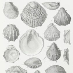
Pictet, F.
Traité de Paléontologie où histoire naturelle des animaux fossiles considérés dans leurs rapports zoologiques et géologiques. [Text and atlas, complete].
Paris, Baillière, 1853-1857. Five parts in five. 8vo (four text parts; 20.7 x 12.7 cm) and 4to (atlas; 30.7 x 23.5 cm). 2742 pp. [I: xiv, 584; II: 727; III: 654; IV: xvi, 768; Atlas; 77]; 110 fine lithographed plates. contemporary uniform pebbled half morocco over marbled boards. Spines with gilt-bordered bands, and gilt title. Marbled endpapers. Speckled edges.
Read more
Buffon, [G. L. L. Comte de]
Oeuvres complètes de Buffon avec la nomenclature Linnéenne et la classification de Cuvier. Revues sur l'édition in 4to de l'Imprimerie Royale et annotées par M. Flourens.
Paris, Garnier frères, 1853-1855. In 12 volumes. Very large 8vo (26.7 x 17.8 cm). Text with one engraved frontispiece, one hand-coloured frontispiece, one engraved portrait of Buffon, and 160 hand-coloured engraved plates and maps, for a total of 163 plates outside the text. Contemporary uniform dark blue half calf over pebbled boards; spines with four raised bands, compartments with gilt vignettes and titles. Iridescent endpapers. All edges gilt.
Read more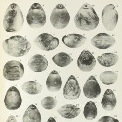
Davidson, T.
A monograph of British Cretaceous Brachiopoda. [AND] M. R. Sahni, the Terebratulidae of the British Chalk. [AND] N. E. Pettitt, The Rhynchonellidae of the British Chalk.
London, The Palaeontographical Society, 1854-1953. 4to (27.0 x 20.6 cm). 205 pp., 21 [12, 9] lithographed plates; 62 pp.; ten plates; 58 pp., three plates. Later half calf, spine with five raised, gilt bordered bands, and gilt titles on spine. Edges speckled red.
Read more
Meyer, C. E. H. von
Ueber den Nager von Waltsch in Böhmen [AND] Physichthys Höninghausi aus dem Uebergangkalke der Eifel [AND] Schildkröte und Vogel aus dem Fischschiefer von Glarus [AND] Helochelys Danubia, aus dem Grünsande von Kelheim in Bayern [AND] Trachyteuthis ensiformisaus dem lithographischen Schiefer in Bayern.
Cassel [Kassel], Palaeontographica, 1855. Six papers in one. 4to (31.0 x 23.2 cm). 35 [5; 4; 12; 10; 4] pp.; six engraved plates [1; 1; 2 (one shared); 2 (one shared); 1], the two turtle and one cephalopod plate double-sized. Contemporary wrappers with the title added in script.
Read more
Jäger, G. [E.]
Über eine neue Species von Ichthyosauren ( Ichthyosaurus longirostris Owen & Jäger), nebst Bemerkungen über die übrigen in de Liasformation Würtembergs aufgefundenen Reptilien.
Breslau und Bonn, Eduard Weber, 1855. Folio (29.6 x 22.5 cm). Title page, 30 pp. (including errata page); one large, folded, lithographed plate. Contemporary blue pebbled cloth over marbled boards.
Read more
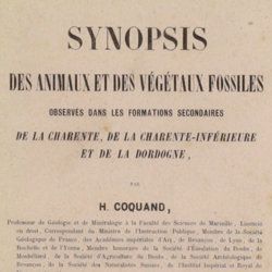
Coquand, H. [J. B.]
Synopsis des animaux et des végétaux fossiles observés dans les formations secondaires de la Charente, de la Charente-inférieure et de la Dordogne.
Marseille, Barlatier-Feissat et Demonchy [for the author], 1860. 8vo (22.6 x 14.7 cm). 146 pp.; original printed wrappers.
Read more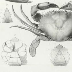
Milne-Edwards, A.
Histoire des crustacés podophthalmaires fossiles.
Paris, Martinet, 1861. 4to (26.5 x 21.5 cm). 222 pp.; one folding table, 16 engraved or lithographed plates (three larger, folded). Later marbled boards with printed label on the front board. Original printed wrappers bound in.
Read more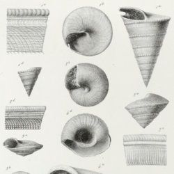

[Geological map]
Geognostische Karte von Württemberg [AND] Begleitworte zur geognostischen Specialkarte von Württemberg.
Stuttgart, Das Königliches Statistisch-topographisches Bureau, Kohlhammer, Kleeblatt, 1863-1892. With 54 chromolithographed folded geological maps, all mounted on linen, numbered 1-48, 50-55, in two original, uniform burgundy boxes with gilt title on the lid. [AND] the "Begleitworte" 34 parts in one. Large 8vo (25.7 x 19.5 cm). Stuttgart, Königlich Statistischen Landesambt, (1865-1892). ca. 1,000 pp., and five hand-coloured wood-engraved or lithographed maps or geological profiles, and four wood-engraved plates. Contemporary half cloth over marbled boards. Spine with gilt title, ornaments, and the Württemberg coat-of-arms; patterned endpapers, and marbled edges.
Read more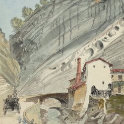
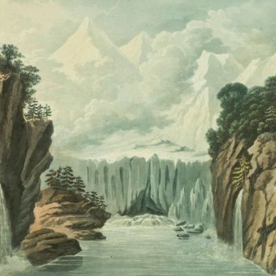
["JAM" (R. de Bouillé, Comte)]
[Original watercolour sketches of French landscapes]
[France], no place, no publisher, ca. 1863-1890. 13 oblong sheets (22.3 x 29.2 cm), all with fine watercolour paintings, either full-sized, or smaller, in a drawn rectangular frame. And one drawing on slightly smaller paper, more sketchy, in pencil.
Read more