General Earth Sciences - Geology
48 items found
Palassou, P. B.
Mémoires pour servir à l'histoire naturelle des Pyrénées, et des pays adjacens. [AND] Suite des mémoires pour servir à l'histoire naturelle des Pyrénées, et des pays adjacens.
Pau, Vignancour, 1815-1819. Two volumes in two (20.7 x 12.7; 19.6 x 12.0 cm). 8vo. 954 pp. [xvi, 485; xxiii, 430]. Contemporary green boards. Spine with gilt bands and red morocco label with gilt title (volume I), and near contemporary half calf over marbled boards. Spine with five raised bands and gilt title. Marbled endpapers (volume II).
Read more
Buch, L. de
Voyage en Norvège et en Laponie, fait dans les années 1806, 1807 et 1808. Traduit de l`Allemand par J. B. B. Eyriés. Précédé d`une introduction de M. A. de Humboldt. Suivi d`un mémoire de M. de Buch, sur la limite des neiges perpétuelles dans le Nord, et enrichi de cartes et de coupes de terrein.
Paris, Gide fils, 1816. Two volumes in two. 8vo (19.9 x 12.6 cm). 953 pp. [xxiv, 472; 457]; three engraved maps, of which two large, folded. Uniform red calf over marbled boards. Spines with gilt ornamental bands, vignettes, and title. Sprinkled edges.
Read more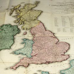
Enouy, J.
The United Kingdom of Great Britain & Ireland, with the adjacent parts of the Continent, from Amsterdam to Paris and Brest, compiled from a variety of the most authentic materials.
London, Samuel Leigh, 1818. Large, folded, coloured map (62.7 x 75.3 cm) of Great Britain and Ireland, and the continental coasts of the Channel and North Sea. In original reddish paper-covered boards, with printed label mounted.
Read more
Radermacher, J. C. M. (ed.)
Bataviaasch Genootschap der Kunsten en Wetenschappen: Verhandelingen. Volume 1.
Batavia, Ter Lands Drukkerij, 1820. 8vo (18.6 x 12.5 cm) 266 pp., 59 pp. Voorbericht [foreword], 23 pp. Nabericht [afterword] and Bladwijzer [index]. Contemporary half calf with mottled paper over boards.
Read more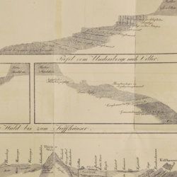
Oeynhausen, C. von and H. von Dechen and H. von La Roche
Geognostische Umrisse der Rheinländer zwischen Basel und Mainz mit besonderer Rücksicht auf das Vorkommen des Steinsalzes, nach Beobachtungen entworfen auf einer Reise im Jahre 1823 gesammelt.
Essen, G. Bädeker, 1825. Two volumes in one. 8vo (19.8 x 12.0 cm). 782 pp.; one folding lithographed plate with several geological profiles. Contemporary half cloth over marbled boards. Paper label with the title in an old hand on the spine. Original endpapers.
Read more
Devèze de Chabrol, J. S. and J. B. Bouillet
Essai géologique et minéralogique sur les environs d'Issoire, département du Puy-de-Dôme, et principalement sur la Montagne de Boulade.
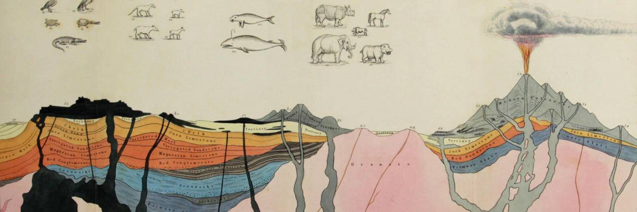
Clermont-Ferrand, Thibaud-Landriot, 1827. Folio (41.0 x 26.2 cm). xii, 104 pp.;hand-coloured lithographed geological map and hand-coloured profile, and 30 lithographed plates depicting vertebrates and several tables, including one very large, folded in the text. Contemporary half morocco over marbled boards. Spine with gilt lines and title. Marbled endpapers; speckled edges.
Read more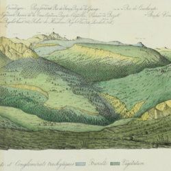
Lecoq, H. and J. B. Bouillet
Coup d'oeil sur la structure géologique et minéralogique du groupe des Monts Dores, accompagné de la description et des échantillons des substances minérales qui le composent.
Paris, Levrault and Clermont-Ferrand, Bouillet, Thibaud-Landriot, 1830. 8vo (20.0 x 13.1 cm). 48 pp.; five handcoloured lithographed plates (two much larger, folded) of geological views and profiles of the volcanological region of Puy-de-Dôme. Later red quarter calf over marbled boards. Gilt title on the spine. Marbled endpapers. Speckled edges.
Read more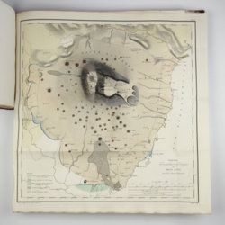
[Various authors]
Annales des Mines. Series III-VI. Atlases.
Paris, Ecole de Mines, 1832-1866. Two series in four. Oblong folio (40.5 x 22.0 cm) with 758 (of 759? see below) engraved and lithographed plates and maps, of which 29 are hand-coloured geological maps or profiles. Contemporary uniform red cloth. Gilt titles on the spines and front boards. Marbled endpapers.
Read more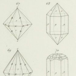
Rose, G.
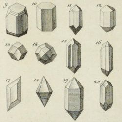
Eléments de cristallographie.
Paris, Hachette et Firmin Didot, 1834. 8vo (19.9 x 12.7 cm). 270 pp.; title page (to IIe partie - planches), 12 pp.; 10 double-sized engraved plates with 121 figures, numbered 1-108 (plates I-IX), and 1-13 (plate X). Contemporary half calf over marbled boards. Spine with gilt lines and title. Marbled endpapers.
Read more
Lecoq, H.
[Auvergne] Itinéraire de Clermont au Puy de Dome, ou description de cette montagne et de la Vallée de Royat et Fontanat; seconde edition. [AND] Two other papers on the geology of Auvergne, by A. C. P. F. Von Lasaulx, and by J. B. Bouillet, bound in.
Paris, J. B. Baillière, 1836. 8vo (21.2 x 13.3 cm). vi, 102 pp. Early 20th century half morocco over marbled boards. Spine with five raised bands and gilt title. Marbled endpapers.
Read more
Unger, F.
Ueber den Einfluss des Bodens auf die Vertheilung der Gewächse nachgewissen in der Vegetation des nordöstlichen Tirols.
Wien, Rohrmann und Schweigerd, 1836. 8vo (21.4 x 13.5 cm). xxiv, 367 pp.; one hand-coloured engraved plate of Kitzbühl, one large, folded, hand-coloured geological-geographical map, one large, folded hand-coloured sheet with geological profile, five folded charts with meteorological observations (four) and botanical observations (one), many tables in the text. Contemporary quarter calf over marbled boards. Spine with gilt lines, vignettes, and title. Marbled endpapers; speckled edges.
Read more
