
France
192 items found
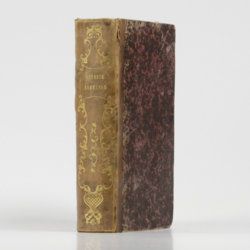
Le Verrier de la Conterie, J.
Venerie Normande, ou l'école de la chasse aux chiens courants, pour le lievre, le chevreuil, le cerf, le daim, le sanglier, le loup, le renard & la loutre; avec les tons de chasse, accompagnés de chacun une explication sur l'occasion & les circonstances où ils doivent être sonnés; et un traité des remedes, un traité sur le droit de suite, & un dictionnaire des termes de chasse, &c.
Rouen, Laurent Dumesnil, 1778. 8vo (20.3 x 12.5 cm). xvi, 526 pp.; 27 fine mostly folded woodengraved plates (some printed on blue paper and/or on recto and verso), mostly by Caron and including 12 large text engravings of music being "Tons de Chasse et Fanfares". Near contemporary half calf over marbled boards. Spine with gilt ornaments and title. Marbled endpapers; speckled edges.
Read more
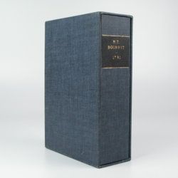
Bourrit, M. T.
Description des Alpes, Pennines et Rhetiennes; dédiée a.s.m. très-chrétienne Louis XVI, roi de France et de Navarre. Tome premier - second. [Complete].
Genève, J. P. Bonnant, 1781. In two volumes. 8vo (21.5 x 13.8 cm). xix, 247 pp.; [ii], 285 pp.; eight engraved plates, mainly of glaciers, and one folded engraved map of the Alps, several wood engraved vignettes in the text. Original uniform blind publishers' wrappers. Spines renewed with later printed labels. Contained in a later blue cloth slipcase (23.2 x 15.8 x 6.9 cm) with black morocco label with gilt title.
Read more
Zannoni, R.
Atlas historique de la France ancienne et moderne contenant tous les lieux illustrés par les événements les plus mémorables de notre histoire; ... depuis Pharamond jusqu'a Louis XV....
Paris, S. Desnos, 1782. Large 4to (28.8 x 22.2 cm). Beautifully engraved double-sized title page; similar folding dedication page (by Desnos and Zannoni), 16 pp.; 59 hand-coloured engraved maps (56 double-sized with ornamental borders; two much larger, of which one dated 1774, and the other 1776). Contemporary half calf over marbled boards. Spine with five raised bands; compartments with gilt floral patterns and red morocco label with gilt title. Edges red.
Read more
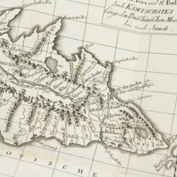
Lesseps, [J. B. B.] de
Herrn von Lesseps Gefährten des Grafen de la Perouse Reise durch Kamtschatka und Sibirien nach Frankreich. Aus dem Französischen übersetzt. Mit Anmerkungen von Johann Reinhold Forster.
Berlin, Voss, 1791. 8vo (22.4 x 14.5 cm). xxviii, 302 [303-544] pp.; two engraved, folded maps, one folded table. Original blind boards.
Read more
Tazewell, G. [Tazewell, W.]
Vade-Mecum in duas partes divisum, quarum prior, nosologiam cullinaeam, posterior, compendium materiae medicae et pharmacopoeiae, exhibet; quibus subjungitur systema formularum recentissimarum, ad normam chymiae recentis ordinatum.
Paris, A. J. Dugour et Durand, 1798. 12mo (16.7 x 10.3 cm). iv, 210 pp. Original speckled boards.
Read more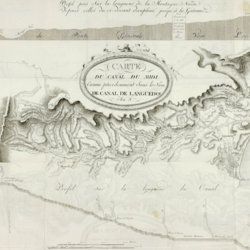
Andreossy, [A.] F.
Histoire du Canal du Midi, connu précédemment sous le nom de Canal de Languedoc.
Paris, F. Dufart, An VIII [1799 or 1800]. 8vo (19.6 x 12.4 cm). Half-title, title page, 415 pp. (numbered [i]-xl, 41-414,[i]); one very large, multi-folded map and five folded charts including one very large, multi-folded). 19th-century polished half calf over marbled boards. Spine with gilt ornamental bands and gilt title. Marbled endpapers.
Read more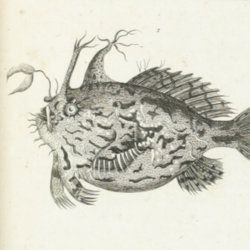
Sonnini, C. S.
Histoire naturelle générale et particulière des poissons. Ouvrage faisant suite à l'histoire naturelle, générale et particulière, composée par Leclerc de Buffon, et mis dans un nouvel ordre par C. S. Sonnini, avec des notes et des additions. Tomes 1-13. [Complete fish section].
Paris, Dufart, An X-XII [1800-1802]. 13 parts in 13. 8vo (19.4 x 12.2 cm). Text; 77 engraved plates. Uniform full tree calf, rich gilt spines, gilt titles on two red morocco labels, marbled flyleaves, all sides marbled.
Read more
Hénon, [J. M.] and [M. J. P.] Mouton-Fontenille [de la Clotte]
l'Art d'empailler des oiseaux contenant des principes nouveaux et sûrs pour leur conserver leurs formes et leurs attitudes naturelles avec la méthode de les classer d'après le systême de Linné. Seconde édition, ornée de cinq planches en taille-douce.
Lyon, Bruyset Ainé, 1802. 8vo (18.9 x 12.3 cm). Half title, title, [iv], xvi, 283 pp.; five folded engraved plates. Old vellum with red and black markings (antiphon music notes and text).
Read more
