
Regional Earth Sciences - Geology
69 items found
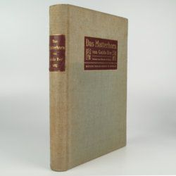
Rey, G.
Das Matterhorn. Vorwort von E. de Amicis with geologische Erläuterungen by V. Novarese.
Stuttgart and Leipzig, Deutsche Verlags-Anstalt, 1905. 4to (29.2 x 21.0 cm). xi, 258 pp.; 35 plates of which 14 are nicely tinted photographic plates after water-colours, mounted on black paper, all by Edoardo Rubino and 11 photographs (most by Vittorio Sella and a few by G. Rey) and ten photographic plates from drawings also by Edoardo Rubino. Furthermore there are 13 images of drawings in the text also by Edoardo Rubino [complete]. Original cloth with bevelled edges, gilt mounted title piece on front board and gilt-lettered spine label. Mottled olive endpapers. Top edge gilt.
Read more
Bonnard, A. H. De
Sur la constance des faits géognostiques, qui accompagnent le gisement du terrain d'Arkose à l'est du Plateau Central de la France.
Paris, Mme Huzard, 1828. 8vo (21.5 x 13.3 cm). 106 pp.; three folded engraved geological profiles. Contemporary polished half calf. Spine with five raised, gilt-bordered bands and gilt title on red morocco shield. Marbled flyleaves.
Read more
Granö, J. G.
Beiträge zur Kenntnis der Eiszeit in der Nordwestlichen Mongolei und einigen ihrer südsibirischen Grenzgebirge. Geomorphologische Studien aus den Jahren 1905, 1906, 1907 und 1909.
Helsingfors, J. Simelii [for the Geographical Society of Finland], 1910. Large 8vo (24.9 x 16.5 cm). iv, 230 pp.; seven large, folded coloured maps, 19 photographic plates. Later quarter calf over pictorial boards.
Read more
Passy, A. [F.]
Description géologique du département de la Seine-Inférieure. [Text and Atlas].
Rouen, Nicétas Periaux, 1832. Two parts [text and atlas] in one. 4to (26.7 x 21.3 cm). 402 pp. [xvi, 371; 15]; 20 engraved plates (several double-sized), of which 15 in original hand-colouring. Contemporary quarter morocco over marbled boards; spine with gilt title. Marbled endpapers.
Read more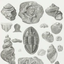
Owen, D. D.
Report of a geological survey of Wisconsin, Iowa and Minnesota; and incidentally of a portion of Nebraska territory. Made under instructions from the United States Treasury Department [AND] Illustrations to the geology report of Wisconsin, Iowa, and Minnesota.
Philadelphia, PA, Lippincott, Grambo & Co., 1852. Two parts in two. 4to (31.1 x 23.0 cm). Engraved frontispiece and title page, 639 pp. (first xxxviii in Roman numbers), numerous fine steel-engravings (text volume); title page, 27 (I-XV, IA-D, IIA-B, IIIA, VA-B, VIIIA, XIIA-B) fine lithographed plates with explanatory text leaves, and 21 mostly folding (all but two) and (partly) hand-coloured (all but two) geological maps, views, and profiles (atlas volume). Original near uniform blind-tooled cloth. Text volume spine with gilt title, plate volume with gilt title on the front board.
Read more
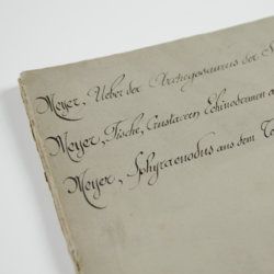
Meyer, H. von
Ueber den Archegosaurus der Steinkohlenformation [AND] Fische, Echinodermen und andere Versteinerungen aus dem Muschelkalk Oberschlesiens [AND] Sphyraenodus aus dem Tertiärsande von Flonheim.
Cassel, Palaeontographica, 1849. 4to (29.2 x 23.0 cm). 76 [5; 68; 3] pp.; four engraved plates. Contemporary wrappers with the titles added in a neat old hand.
Read more
Canavari, M. (ed.)
Palaeontologia della Somalia. Fossili raccolti dalle Missioni Stefanini-Paoli (1913) e Stefanini-Puccioni (1924) e da altri.
Pisa, Museo Geologico della R. Università di Pisa, 1931-1939 [REPRINT Bologna, Forni, 1969]. In five volumes. 4to (31.2 x 21.4 cm). 1,115 pp. [216; 192; 301; 89; 270, 47]; 111 plates [17; 24; 26; 12; 27, 5]; numerous text illustrations. Original uniform printed wrappers.
Read more
Forbes, J. D.
Reisen in den Savoyer Alpen und in anderen Theilen der Penninen-Kette, nebst Beobachtungen über die Gletscher.
Stuttgart, Schweizerbart, 1845. 8vo (21.0 x 13.3 cm). xii, 386 pp.; seven lithographed plates (of which one hand-coloured) and two folded lithographed maps depicting the Chamonix Alps. Early 20th-century cloth with mounted title and backstrip from original printed boards and spine.
Read more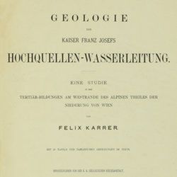
Karrer, F.
Geologie der Kaiser Franz Josefs Hochquellen-Wasserleitung. Eine Studie in den Tertiär-Bildungen am Westrande des alpinen Theiles der Niederung von Wien.
Wien, Hölder, 1877. Large 4to (33.5 x 25.5 cm). xiii, 420 pp.; 96 text engravings, 20 folded profiles, maps and lithographed plates, mostly coloured and several very large (size up to 32 x 100 cm), seven folded charts and tables. Later half cloth with paper label on the spine.
Read more
Hochstetter, F. von and A. Petermann.
The geology of New Zealand: in explanation of the geographical and topographical atlas of New Zealand by Dr. F. Von Hochstetter and Dr. A. Petermann, from the Scientific Publications of the Novara Expedition. Translated by C. F. Fischer. Also, lectures by Dr. F. Hochstetter delivered in New Zealand.
Auckland, T. Delattre, 1864. 8vo (21.0 x 13.6 cm). Title page, 113 pp. Original grained red cloth with gilt title on the front board.
Read more
Cuvier, G. and A. [T.] Brongniart
Essai sur la géographie minéralogique des environs de Paris. Proof copy of the introductions, with corrections by Brogniart.
Paris, Institut Impériale de France, [1809 or 1810]. 4to (25.0 x 20.0 cm). 33 pp. Not bound. In a 20th century blue hardcover paper drop-box (26.8 x 22.0 cm) with printed label on the top board.
Read more
Allemann, F.
Geologische Karte Fürstentum Liechtenstein.
[Vaduz], Regierung des Fürstentums Liechtenstein, 1953. Large (102.0 x 67.0 cm), folded map, consisting of 25 rectangular sheets in full colour, mounted on linen. Handwritten and stamped label on the front-facing part of the linen map verso.
Read more

Meyer, C. E. H. von
Ueber den Nager von Waltsch in Böhmen [AND] Physichthys Höninghausi aus dem Uebergangkalke der Eifel [AND] Schildkröte und Vogel aus dem Fischschiefer von Glarus [AND] Helochelys Danubia, aus dem Grünsande von Kelheim in Bayern [AND] Trachyteuthis ensiformisaus dem lithographischen Schiefer in Bayern.
Cassel [Kassel], Palaeontographica, 1855. Six papers in one. 4to (31.0 x 23.2 cm). 35 [5; 4; 12; 10; 4] pp.; six engraved plates [1; 1; 2 (one shared); 2 (one shared); 1], the two turtle and one cephalopod plate double-sized. Contemporary wrappers with the title added in script.
Read more
Rothpletz, A.
Ein geologischer Querschnitt durch die Ost-Alpen nebst Anhang über die sog. Glarner Doppelfalte.
Stuttgart, E. Schweizerbart (E. Koch), 1894. 8vo (22.4 x 15.4 cm). iv, 208 pp.; two full colour folded profiles of which one measuring 22.5 x 352.0 cm (!), 115 text illustrations. Contemporary half cloth over marbled boards. Gilt lines and two red morocco labels with gilt title on the spine. Edges speckled.
Read more
Catullo, T. A.
Trattato sopra la costituzione geognostico-fisica dei terreni alluviani o postdiluviani delle provincie Venete.
Padova, Cartallier e Sicca, 1838. 8vo (21.2 x 13.3 cm). Title page with engraved vignette, [iv], 512 pp.; several tables in the text. Mid-19th-century pebbled cloth. Gilt title on the spine.
Read more
Spencer, [W.] B. (ed.)
Report on the work of the Horn Scientific Expedition to Central Australia. Part I. Introduction, narrative, summary of results, supplement to zoological report, map.
London, Dulau; Melbourne, Mullen and Slade, 1896. 4to (25.6 x 19.2cm). xviii, 220 pp.; 11 plates, seven text illustrations, one large, multi-folded map. Original azure buckram with gilt title on the spine.
Read more
Ettingshausen, C., von
Die Fossile Flora des Tertiär-Beckens von Bilin. I Theil. (Enthaltend die Thallophyten, Kryptogamischen Gefässpflanzen; Monokotyledonen, Coniferen, Julifloren und Oleraceen).
Wien, Kaiserlichen Akademie der Wissenschaften, 1867. 4to (29.6 x 23.1 cm). 95 pp.; 30 tinted lithographed plates. Later boards, printed label mounted on front board.
Read more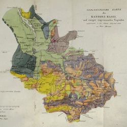
Merian, P.
Uebersicht der Beschaffenheit der Gebirgsbildungen in den Umgebungen von Basel, mit besondrer Hinsicht auf das Juragebirge im Allgemeinen.
Basel, Schweighauser, 1821. 8vo (20.2 x 12.1 cm). xii, 156 pp; one large, folded hand-coloured map and one hand-coloured plate. Original printed wrappers.
Read more
Buch, L. de
Voyage en Norvège et en Laponie, fait dans les années 1806, 1807 et 1808. Traduit de l`Allemand par J. B. B. Eyriés. Précédé d`une introduction de M. A. de Humboldt. Suivi d`un mémoire de M. de Buch, sur la limite des neiges perpétuelles dans le Nord, et enrichi de cartes et de coupes de terrein.
Paris, Gide fils, 1816. Two volumes in two. 8vo (19.9 x 12.6 cm). 953 pp. [xxiv, 472; 457]; three engraved maps, of which two large, folded. Uniform red calf over marbled boards. Spines with gilt ornamental bands, vignettes, and title. Sprinkled edges.
Read more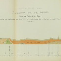
Belgrand, [M. F.] E.
Histoire générale de Paris. La Seine. I. Le bassin Parisien aux âges antéhistoriques.
Paris, Imprimerie Impériale, 1869. In three parts (Texte, Atlas de Paléontologie, and Planches de Géologie et de Conchyliologie). Large 4to and folio (33.8 x 23.9 cm). Texte: cvi, 289 pp., four double-sized coloured maps, 36 engraved text figures, five tissue-guarded plates (four profiles and one with stone age axes); Atlas: 82 [46, a-d] pp.; seven text engravings, 86 plates [1-79, 29bis, 48bis, 53bis, 59bis, 59ter, 62bis, 62ter, 78bis) being tissue guarded heliogravures of mammalian bones, including human skulls, etc., and stone age tools. Géologie and Conchyliologie, 32 pp. Three lithographed plates of shells, three very large folded, coloured geological profiles (numbered 5-7, being a suite to the maps in the text part). All in original green, printed boards or wrappers. Not in Nissen, ZBI.
Read more
Torre, G. M. Della
Histoire et phénomènes du Vésuve. Exposés par le Pere Dom Jean-Marie Della-Torre, clerc régulier sommasque, garde bde la bibliothéque & du cabinet du roi des Deux-Siciles, & correspondant de l'Académie Royale des Sciences de Paris. Traduction de l'Italien par M. l'abbé Péton.
Paris, Jean-Thomas Hérissant, 1760. 12mo (16.3 x 9.2 cm). xxiv, 399 pp., one large folded map of Mount Vesuvius, the Bay of Naples and surroundings, and five folded plates with panoramas and other views of the volcano, caldera, etc. Contemporary full mottled calf. Spine with five raised bands. Compartments with gilt floral vignettes and small red morocco label with gilt title. Marbled endpapers, marbled edges.
Read more
Lippi, C.
Fu il fuoco, o l'acqua che sotterro Pompei ed Ercolano? Scoperta geologico-istorica, fatta dall'autore il di 14 e 26 Ottobre 1810, e da lui scritta nelle lingue latina, inglese, francese, italiana, tedesca, e spagnuola in due lettere. Seguite dalle scritture pro et contra, presentate all' Accademia di scienze di Napoli, per di lei ordine; e dalle decisioni di questa Società, relative al' argomento. Prima edizione Italiana.
Napoli, Domenico Sangiacomo, 1816. 8vo (18.9 x 11.4 cm). [iv], 384 pp.; one folded plate. Contemporary half calf over marbled boards. Rich gilt spine. Edges yellow.
Read more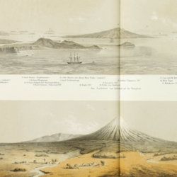
Hochstetter, [C. G.] F. [Ritter] von
Reise der oesterreichischen Fregatte Novara um die Erde in den Jahren 1857, 1858, 1859 unter den Befehlen des Commodore B. von Wüllerstorf-Urbair. Geologischer Theil. Erster Band: Erste Abtheilung, Geologie von Neu-Seeland [AND] Zweite Abtheilung, Paläontologie von Neu-Seeland.
Wien, Karl Gerold's Sohn, 1864-1865. In two volumes. 4to (31.0 x 24.2 cm). Volume 1 (1864): Half-title and title page; tissue-guarded frontispiece; xlvii, 274 pp.; two unnumbered chromolithographed plates (tissue-guarded); six large, folded, full-colour tissue-guarded maps [Tafeln 1-6]; five plates with engraved or tinted views [Tafeln 7-11]; numerous text engravings; volume 2 (1865): half-title and title page, sectional titles; pp. v-vii, 1-318; 26 lithographed plates [numbered I-XXVI], of which several tinted, and each with explanatory text leaves. Original uniform, printed wrappers.
Read more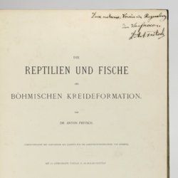
Fritsch, A. [J.]
Die Reptilien und Fische der böhmischen Kreideformation.
Prag, Verlag des Verfassers (Fr. Řivnáč), 1878. Large 4to (33.5 x 25.1 cm). [ii], 44, [ii] pp.; 66 text engravings; ten lithographed plates of which nine tinted, and two larger, folded. Original blind quarter linen over printed boards.
Read more
Unger, F.
Ueber den Einfluss des Bodens auf die Vertheilung der Gewächse nachgewissen in der Vegetation des nordöstlichen Tirols.
Wien, Rohrmann und Schweigerd, 1836. 8vo (21.4 x 13.5 cm). xxiv, 367 pp.; one hand-coloured engraved plate of Kitzbühl, one large, folded, hand-coloured geological-geographical map, one large, folded hand-coloured sheet with geological profile, five folded charts with meteorological observations (four) and botanical observations (one), many tables in the text. Contemporary quarter calf over marbled boards. Spine with gilt lines, vignettes, and title. Marbled endpapers; speckled edges.
Read more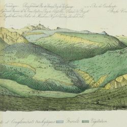
Lecoq, H. and J. B. Bouillet
Coup d'oeil sur la structure géologique et minéralogique du groupe des Monts Dores, accompagné de la description et des échantillons des substances minérales qui le composent.
Paris, Levrault and Clermont-Ferrand, Bouillet, Thibaud-Landriot, 1830. 8vo (20.0 x 13.1 cm). 48 pp.; five handcoloured lithographed plates (two much larger, folded) of geological views and profiles of the volcanological region of Puy-de-Dôme. Later red quarter calf over marbled boards. Gilt title on the spine. Marbled endpapers. Speckled edges.
Read more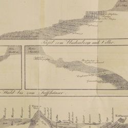
Oeynhausen, C. von and H. von Dechen and H. von La Roche
Geognostische Umrisse der Rheinländer zwischen Basel und Mainz mit besonderer Rücksicht auf das Vorkommen des Steinsalzes, nach Beobachtungen entworfen auf einer Reise im Jahre 1823 gesammelt.
Essen, G. Bädeker, 1825. Two volumes in one. 8vo (19.8 x 12.0 cm). 782 pp.; one folding lithographed plate with several geological profiles. Contemporary half cloth over marbled boards. Paper label with the title in an old hand on the spine. Original endpapers.
Read more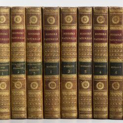
Sonnini, C. S.
Histoire naturelle générale et particulière, par Leclerc de Buffon; nouvelle edition accompagnée de notes, et dans laquelle les supplémens sont insérés dans le premier texte, à la place qui leur convient. Ouvrage formant un cours complet d'histoire naturelle; redige par C. S. Sonnini, membre de plusieurs sociétés savantes. Tomes Mineraux 1-16. [Théorie de la terre 1-3; Epoques de la nature; Introduction a l'histoire des minéraux 1-3; Mineraux 1-9].
Paris, Dufart, An VIII (1798) - X (1800). 16 parts in 16. 8vo (19.5 x 12.2 cm). Engraved frontispiece, 7156 pp.; nine engraved plates, four folded maps. Contemporary uniform full tree calf. Boards with gilt ornamented borders and gilt dentelles. Rich gilt spines, gilt titles on two (red and black) morocco labels, marbled flyleaves, all edges speckled red on yellow.
Read more
Devèze de Chabrol, J. S. and J. B. Bouillet
Essai géologique et minéralogique sur les environs d'Issoire, département du Puy-de-Dôme, et principalement sur la Montagne de Boulade.
Clermont-Ferrand, Thibaud-Landriot, 1827. Folio (41.0 x 26.2 cm). xii, 104 pp.;hand-coloured lithographed geological map and hand-coloured profile, and 30 lithographed plates depicting vertebrates and several tables, including one very large, folded in the text. Contemporary half morocco over marbled boards. Spine with gilt lines and title. Marbled endpapers; speckled edges.
Read more
Serao, F.
Histoire du Mont Vésuve, avec l'explication des phenomenes qui ont coûtume d'accompagner les embrasements de cette montagne. Le tout traduit de l'Italien de l'Académie des Sciences de Naples. Par M. Duperron de Castera. Dédiée a monseigneur le Dauphin.
Paris, Huart, 1741. Small 8vo (16.6 x 9.5 cm). xxiii, 361, [iii] pp.; three large folded plates, one very large folded table. Contemporary full calf. Spine with five raised bands. Compartments with rich gilt floral patterns and red morocco label with gilt title. Marbled endpapers. Edges red.
Read more
Lecoq, H.
[Auvergne] Itinéraire de Clermont au Puy de Dome, ou description de cette montagne et de la Vallée de Royat et Fontanat; seconde edition. [AND] Two other papers on the geology of Auvergne, by A. C. P. F. Von Lasaulx, and by J. B. Bouillet, bound in.
Paris, J. B. Baillière, 1836. 8vo (21.2 x 13.3 cm). vi, 102 pp. Early 20th century half morocco over marbled boards. Spine with five raised bands and gilt title. Marbled endpapers.
Read more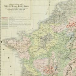
Beche, H. de la
A selection of the Geological Memoirs, contained in the Annales des Mines, together with a synoptical table of equivalent formations and Brongniart's table of the classification of mixed rocks. Translated with notes by H. T. de la Beche, Esq.
London, William Phillips, 1824. 8vo (21.1 x 13.3 cm). xxii, 335 pp.; one hand-coloured folded geological map of France and the Netherlands including a great part of Germany, the Alps and northern Italy, by J. d'Omalius d'Halloy (numbered plate 11 [not II]) and two further hand-coloured geological maps or profiles (numbered I-II), eight folded lithographed plates (numbered III-X), including a very fine view of the coalmine at Treuil near St. Etienne, one folding table. Contemporary half calf over marbled boards. Spine with gilt lines and title. Edges speckled red.
Read more
Carez, L. [L. H.]
La géologie des Pyrénées Françaises.
Paris, Imprimerie Nationale, 1903-1909. In six volumes, including the supplement. Large 4to (29.5 x 22.6 cm). 3,908 [ix, 3,899] pp.; 39 mainly geological folded maps or profiles (six in full-colour), and heliogravures (photogravures), some with printed overlays. Uniform contemporary half calf over marbled boards. Spines with four raised bands and gilt title.
Read more
Tollmann, A.
Das Neogen am Südwestrand des Leithagebirges zwischen Eisenstadt und Hornstein. Dissertation zur Erlangung des Doktorgrades an der Philosophischen Fakultät der Universität Wien.
Wien, [not published], 1953. Small folio (29.8 x 21.0 cm). 226 pp.; 28 text figures (tipped in), three large folded maps (one hand-coloured), five folded tables and graphs. Black half cloth. Hand-written label on the spine.
Read more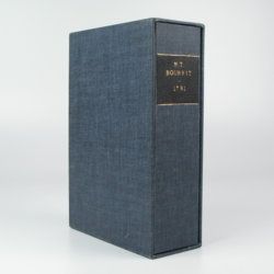
Bourrit, M. T.
Description des Alpes, Pennines et Rhetiennes; dédiée a.s.m. très-chrétienne Louis XVI, roi de France et de Navarre. Tome premier - second. [Complete].
Genève, J. P. Bonnant, 1781. In two volumes. 8vo (21.5 x 13.8 cm). xix, 247 pp.; [ii], 285 pp.; eight engraved plates, mainly of glaciers, and one folded engraved map of the Alps, several wood engraved vignettes in the text. Original uniform blind publishers' wrappers. Spines renewed with later printed labels. Contained in a later blue cloth slipcase (23.2 x 15.8 x 6.9 cm) with black morocco label with gilt title.
Read more
Mille, M. et al.
Contrôle des Chemins de Fer. Ligne de Paris à Brest. Réseau d'Orléans. Profil géologique suivant le tracé du chemin de fer dressé sur les indications de M.M. Triger et Delesse. Notice par M. Mille ingénieur en Chef des Ponts et Chaussées 1867.
Paris, Jules Bonaventure, 1866-1867. In four parts. 4to. Title-page, 9 pp. (text volume); one folded, chromolithographed profile (31.0 x 99.8 cm), titled: Coupe des huillères de Chalonnes d'après les travaux des ingénieurs de la mine; one very long folded profile (31 x 957 cm, including title and legend) titled: Section de Paris à Angers par Vendôme et Tours; a second very long folded chromolithographed profile (31 x 1147 [!] cm), title: Section de Angers à Brest par Nantes et Chateaulin. All four contained in a blind stamped cloth portfolio with gilt title on the spine and top board.
Read more
Hamilton, W.
Voyage à la cote septentrionale du Comté d'Antrim en Irlande, et à l'ile de Raghery, contenant l'histoire naturelle de ses productions volcaniques & plusieurs observations sur les antiquités & moeurs de ce pays... auquel on a ajouté l'essai sur l'oryctographie du Derbyshire par M. Ferber, traduit de l'Allemand.
Paris, Cuchet, 1790. 8vo (19.6 x 12.5 cm). viii, 239 pp.; engraved folding plate showing several geological layers of Derbyshire. Contemporary full mottled calf. Spine rich gilt with floral vignettes, small red morocco label with gilt title. Marbled endpapers, red edges.
Read more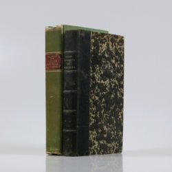
Palassou, P. B.
Mémoires pour servir à l'histoire naturelle des Pyrénées, et des pays adjacens. [AND] Suite des mémoires pour servir à l'histoire naturelle des Pyrénées, et des pays adjacens.
Pau, Vignancour, 1815-1819. Two volumes in two (20.7 x 12.7; 19.6 x 12.0 cm). 8vo. 954 pp. [xvi, 485; xxiii, 430]. Contemporary green boards. Spine with gilt bands and red morocco label with gilt title (volume I), and near contemporary half calf over marbled boards. Spine with five raised bands and gilt title. Marbled endpapers (volume II).
Read more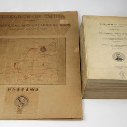
Willis, B. (ed.)
Research in China. In three volumes and atlas. 1(1). Descriptive topography and geology; 1(2). Petrography and zoology; 2. Systematic geology; 3. The Cambrian faunas of China. A report on Ordovician fossils collected in eastern Asia in 1903-04. A report on Upper Paleozoic fossils collected in China 1903-04; [4.] Geographical and geological maps. [Complete].
Washington, DC, The Carnegie Institution of Washington, 1907-1913. In five parts (four text and plate volumes, one atlas). 4to (29.8 x 24.0 cm). Text; 101 plates, including six chromolithographs of birds, and geological maps; folio atlas (52.7 x 45.0 cm) with 42 mostly coloured geological and topographical maps (some with explanatory text or figures). Original printed wrappers.
Read more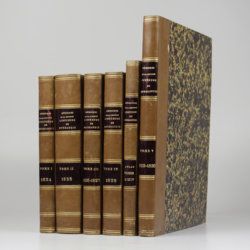
[Various geologists and palaeontologists]
Mémoires de la Société Linnéenne de Normandie. Volumes I-V. [IINCLUDING Société Linnéenne de Calvados].
Caen, Société Linnéenne de Normandie, 1824-1835. Five volumes in six. 8vo (volumes I-IV, 21.0 x 13.2 cm), 4to (volume V, 27.6 x 22.0 cm), and oblong folio (atlas to volumes II-IV, 22.5 x 31.0 cm). Title pages; 15 lithographed (partly folded) plates in volume I, one hand-coloured geological map, 39 lithographed plates in the atlas volume, mainly depicting lichens by Delise, and geological maps (11 hand-coloured). Uniform later half calf over marbled boards. Spines with gilt title.
Read more
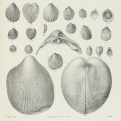
Stoliczka, F.
Palaeontologia Indica, being figures and descriptions of the organic remains procured during the progress of the geological survey of India. Vol. III. The Pelecypoda, with a review of all known genera of this class, fossil and recent.
Calcutta, Geological Survey Office, 1871. Folio (37.0 x 25.1 cm). Title page, xxii, 538 pp.; 50 lithographed plates with explanatory text leaves. Near-contemporary half calf with blind-tooled borders over pebbled boards. Spine with gilt lines, and two red morocco labels with gilt title.
Read more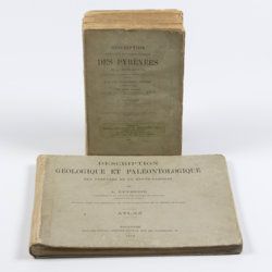
Leymerie, A. [F. G. A.]
Description géologique et paléontologique des Pyrenées de la Haute-Garonne accompagnée d'une carte topographique et géologique à l'echelle 1:200.000 et d'un Atlas...
Toulouse, Privat, 1878, 1881. In two volumes. Text (1881) 8vo (24.0 x 16.0 cm). Atlas (1878) oblong 4to (23.5 x 31.5 cm). 1,027 pp.; 51 lithographed plates of which 11 tinted or coloured (and of which 30 are on fossils), including a large folded transection of the Pyrenees, Haute Garonne, and the large coloured geological map (with 20 colours) mounted on linen. Original printed wrappers (text) and boards (atlas).
Read more
