
Regional Earth Sciences - Geology
69 items found
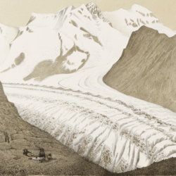
Agassiz, L.
Untersuchungen über die Gletscher. [Complete text and atlas].
Solothurn, Jent & Gassmann, 1840-1841; Neuchatel, H. Nicolet, 1840. Text: 8vo (21.5 x 14.2 cm). xii, 326, [i] pp. 19th-century pebbled half cloth over marbled boards. Spine with gilt ornamental bands and title. Greenish endpapers. Subtly marbled edges. Atlas: Oblong folio (29.7 x 44.0 cm). 18 lithographed plates of which 14 with printed overlays (as intended). Contemporary green quarter calf over green boards. Spine with gilt bands. Original pictorial title mounted on front board.
Read more
Allemann, F.
Geologische Karte Fürstentum Liechtenstein.
[Vaduz], Regierung des Fürstentums Liechtenstein, 1953. Large (102.0 x 67.0 cm), folded map, consisting of 25 rectangular sheets in full colour, mounted on linen. Handwritten and stamped label on the front-facing part of the linen map verso.
Read more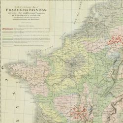
Beche, H. de la
A selection of the Geological Memoirs, contained in the Annales des Mines, together with a synoptical table of equivalent formations and Brongniart's table of the classification of mixed rocks. Translated with notes by H. T. de la Beche, Esq.
London, William Phillips, 1824. 8vo (21.1 x 13.3 cm). xxii, 335 pp.; one hand-coloured folded geological map of France and the Netherlands including a great part of Germany, the Alps and northern Italy, by J. d'Omalius d'Halloy (numbered plate 11 [not II]) and two further hand-coloured geological maps or profiles (numbered I-II), eight folded lithographed plates (numbered III-X), including a very fine view of the coalmine at Treuil near St. Etienne, one folding table. Contemporary half calf over marbled boards. Spine with gilt lines and title. Edges speckled red.
Read more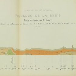
Belgrand, [M. F.] E.
Histoire générale de Paris. La Seine. I. Le bassin Parisien aux âges antéhistoriques.
Paris, Imprimerie Impériale, 1869. In three parts (Texte, Atlas de Paléontologie, and Planches de Géologie et de Conchyliologie). Large 4to and folio (33.8 x 23.9 cm). Texte: cvi, 289 pp., four double-sized coloured maps, 36 engraved text figures, five tissue-guarded plates (four profiles and one with stone age axes); Atlas: 82 [46, a-d] pp.; seven text engravings, 86 plates [1-79, 29bis, 48bis, 53bis, 59bis, 59ter, 62bis, 62ter, 78bis) being tissue guarded heliogravures of mammalian bones, including human skulls, etc., and stone age tools. Géologie and Conchyliologie, 32 pp. Three lithographed plates of shells, three very large folded, coloured geological profiles (numbered 5-7, being a suite to the maps in the text part). All in original green, printed boards or wrappers. Not in Nissen, ZBI.
Read more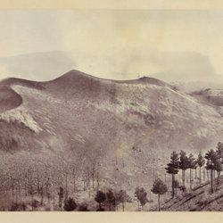
Berthier, P. [M.]
Photographic panorama of Mount Etna.
Paris, Paul Berthier, 1865. Very large board (93.0 x 45.0 cm), with original mounted albumen silver prints (panorama, in two parts of 25.0 x 36.2 cm and 25.0 x 35.0 cm, for a continuous image with a total width of 71.2 cm). Paul Berthier printed studio label pasted on verso.
Read more
Bonnard, A. H. De
Sur la constance des faits géognostiques, qui accompagnent le gisement du terrain d'Arkose à l'est du Plateau Central de la France.
Paris, Mme Huzard, 1828. 8vo (21.5 x 13.3 cm). 106 pp.; three folded engraved geological profiles. Contemporary polished half calf. Spine with five raised, gilt-bordered bands and gilt title on red morocco shield. Marbled flyleaves.
Read more
Bourrit, M. T.
Description des Alpes, Pennines et Rhetiennes; dédiée a.s.m. très-chrétienne Louis XVI, roi de France et de Navarre. Tome premier - second. [Complete].
Genève, J. P. Bonnant, 1781. In two volumes. 8vo (21.5 x 13.8 cm). xix, 247 pp.; [ii], 285 pp.; eight engraved plates, mainly of glaciers, and one folded engraved map of the Alps, several wood engraved vignettes in the text. Original uniform blind publishers' wrappers. Spines renewed with later printed labels. Contained in a later blue cloth slipcase (23.2 x 15.8 x 6.9 cm) with black morocco label with gilt title.
Read more
Buch, L. de
Voyage en Norvège et en Laponie, fait dans les années 1806, 1807 et 1808. Traduit de l`Allemand par J. B. B. Eyriés. Précédé d`une introduction de M. A. de Humboldt. Suivi d`un mémoire de M. de Buch, sur la limite des neiges perpétuelles dans le Nord, et enrichi de cartes et de coupes de terrein.
Paris, Gide fils, 1816. Two volumes in two. 8vo (19.9 x 12.6 cm). 953 pp. [xxiv, 472; 457]; three engraved maps, of which two large, folded. Uniform red calf over marbled boards. Spines with gilt ornamental bands, vignettes, and title. Sprinkled edges.
Read more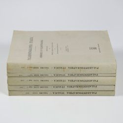
Canavari, M. (ed.)
Palaeontologia della Somalia. Fossili raccolti dalle Missioni Stefanini-Paoli (1913) e Stefanini-Puccioni (1924) e da altri.
Pisa, Museo Geologico della R. Università di Pisa, 1931-1939 [REPRINT Bologna, Forni, 1969]. In five volumes. 4to (31.2 x 21.4 cm). 1,115 pp. [216; 192; 301; 89; 270, 47]; 111 plates [17; 24; 26; 12; 27, 5]; numerous text illustrations. Original uniform printed wrappers.
Read more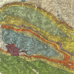
Carez, L. [L. H.]
La géologie des Pyrénées Françaises.
Paris, Imprimerie Nationale, 1903-1909. In six volumes, including the supplement. Large 4to (29.5 x 22.6 cm). 3,908 [ix, 3,899] pp.; 39 mainly geological folded maps or profiles (six in full-colour), and heliogravures (photogravures), some with printed overlays. Uniform contemporary half calf over marbled boards. Spines with four raised bands and gilt title.
Read more
Catullo, T. A.
Trattato sopra la costituzione geognostico-fisica dei terreni alluviani o postdiluviani delle provincie Venete.
Padova, Cartallier e Sicca, 1838. 8vo (21.2 x 13.3 cm). Title page with engraved vignette, [iv], 512 pp.; several tables in the text. Mid-19th-century pebbled cloth. Gilt title on the spine.
Read more
